You are here: Home > Network List > TA - USArray Transportable Network (new EarthScope stations) Stations List
> Station J12A Stokes Ranch, Hill City, ID, USA > Earthquake Result Viewer
J12A Stokes Ranch, Hill City, ID, USA - Earthquake Result Viewer

| Earthquake location: |
Near West Coast Of Colombia |
| Earthquake latitude/longitude: |
3.0/-78.0 |
| Earthquake time(UTC): |
2007/09/10 (253) 01:49:14 GMT |
| Earthquake Depth: |
31 km |
| Earthquake Magnitude: |
6.1 MB, 6.7 MS, 6.8 MW |
| Earthquake Catalog/Contributor: |
WHDF/NEIC |
|
| Network: |
TA USArray Transportable Network (new EarthScope stations) |
| Station: |
J12A Stokes Ranch, Hill City, ID, USA |
| Lat/Lon: |
43.25 N/115.10 W |
| Elevation: |
1587 m |
|
| Distance: |
51.9 deg |
| Az: |
325.912 deg |
| Baz: |
130.0 deg |
| Ray Param: |
0.067051545 |
| Estimated Moho Depth: |
60.75 km |
| Estimated Crust Vp/Vs: |
1.67 |
| Assumed Crust Vp: |
6.291 km/s |
| Estimated Crust Vs: |
3.773 km/s |
| Estimated Crust Poisson's Ratio: |
0.22 |
|
| Radial Match: |
96.96017 % |
| Radial Bump: |
231 |
| Transverse Match: |
87.58691 % |
| Transverse Bump: |
400 |
| SOD ConfigId: |
2564 |
| Insert Time: |
2010-03-07 03:46:18.526 +0000 |
| GWidth: |
2.5 |
| Max Bumps: |
400 |
| Tol: |
0.001 |
|
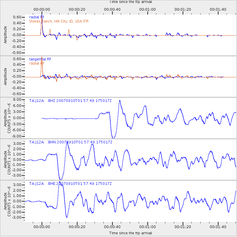
Signal To Noise
| Channel | StoN | STA | LTA |
| TA:J12A: :BHN:20070910T01:57:49.175017Z | 4.474982 | 6.36236E-7 | 1.4217622E-7 |
| TA:J12A: :BHE:20070910T01:57:49.175017Z | 5.345615 | 5.742218E-7 | 1.07419226E-7 |
| TA:J12A: :BHZ:20070910T01:57:49.175017Z | 18.504343 | 1.5964191E-6 | 8.6272664E-8 |
| Arrivals |
| Ps | 6.8 SECOND |
| PpPs | 24 SECOND |
| PsPs/PpSs | 31 SECOND |


