You are here: Home > Network List > TA - USArray Transportable Network (new EarthScope stations) Stations List
> Station J12A Stokes Ranch, Hill City, ID, USA > Earthquake Result Viewer
J12A Stokes Ranch, Hill City, ID, USA - Earthquake Result Viewer
| Earthquake location: |
Santa Cruz Islands |
| Earthquake latitude/longitude: |
-11.6/165.8 |
| Earthquake time(UTC): |
2007/09/02 (245) 01:05:18 GMT |
| Earthquake Depth: |
35 km |
| Earthquake Magnitude: |
5.9 MB, 7.3 MS, 7.2 MW, 6.9 ME |
| Earthquake Catalog/Contributor: |
WHDF/NEIC |
|
| Network: |
TA USArray Transportable Network (new EarthScope stations) |
| Station: |
J12A Stokes Ranch, Hill City, ID, USA |
| Lat/Lon: |
43.25 N/115.10 W |
| Elevation: |
1587 m |
|
| Distance: |
90.1 deg |
| Az: |
45.855 deg |
| Baz: |
254.209 deg |
| Ray Param: |
0.041693598 |
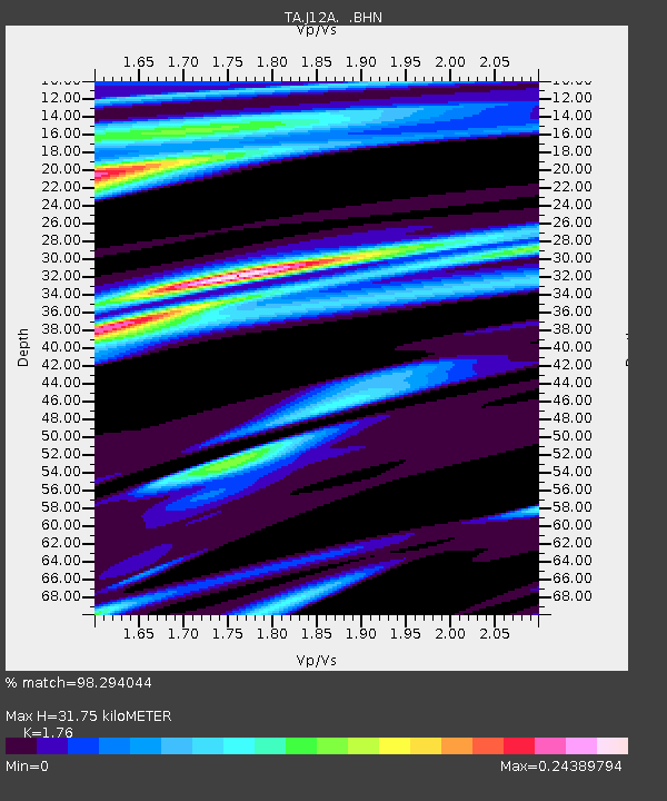
| Estimated Moho Depth: |
31.75 km |
| Estimated Crust Vp/Vs: |
1.76 |
| Assumed Crust Vp: |
6.291 km/s |
| Estimated Crust Vs: |
3.575 km/s |
| Estimated Crust Poisson's Ratio: |
0.26 |
|
| Radial Match: |
98.294044 % |
| Radial Bump: |
155 |
| Transverse Match: |
88.39821 % |
| Transverse Bump: |
400 |
| SOD ConfigId: |
2564 |
| Insert Time: |
2010-03-07 03:46:21.369 +0000 |
| GWidth: |
2.5 |
| Max Bumps: |
400 |
| Tol: |
0.001 |
|

Signal To Noise
| Channel | StoN | STA | LTA |
| TA:J12A: :BHN:20070902T01:17:43.225012Z | 3.5197182 | 2.1763493E-7 | 6.1833056E-8 |
| TA:J12A: :BHE:20070902T01:17:43.225012Z | 8.7504015 | 7.2543287E-7 | 8.290281E-8 |
| TA:J12A: :BHZ:20070902T01:17:43.225012Z | 30.618885 | 2.1432593E-6 | 6.999795E-8 |
| Arrivals |
| Ps | 3.9 SECOND |
| PpPs | 14 SECOND |
| PsPs/PpSs | 18 SECOND |


