You are here: Home > Network List > TA - USArray Transportable Network (new EarthScope stations) Stations List
> Station J12A Stokes Ranch, Hill City, ID, USA > Earthquake Result Viewer
J12A Stokes Ranch, Hill City, ID, USA - Earthquake Result Viewer

| Earthquake location: |
Jujuy Province, Argentina |
| Earthquake latitude/longitude: |
-22.2/-65.8 |
| Earthquake time(UTC): |
2007/07/21 (202) 15:34:52 GMT |
| Earthquake Depth: |
290 km |
| Earthquake Magnitude: |
5.8 MB, 6.4 MW, 6.3 MW |
| Earthquake Catalog/Contributor: |
WHDF/NEIC |
|
| Network: |
TA USArray Transportable Network (new EarthScope stations) |
| Station: |
J12A Stokes Ranch, Hill City, ID, USA |
| Lat/Lon: |
43.25 N/115.10 W |
| Elevation: |
1587 m |
|
| Distance: |
79.3 deg |
| Az: |
325.673 deg |
| Baz: |
134.316 deg |
| Ray Param: |
0.04828566 |
| Estimated Moho Depth: |
35.5 km |
| Estimated Crust Vp/Vs: |
1.77 |
| Assumed Crust Vp: |
6.291 km/s |
| Estimated Crust Vs: |
3.544 km/s |
| Estimated Crust Poisson's Ratio: |
0.27 |
|
| Radial Match: |
96.41885 % |
| Radial Bump: |
362 |
| Transverse Match: |
85.812065 % |
| Transverse Bump: |
400 |
| SOD ConfigId: |
2564 |
| Insert Time: |
2010-03-07 03:46:35.269 +0000 |
| GWidth: |
2.5 |
| Max Bumps: |
400 |
| Tol: |
0.001 |
|
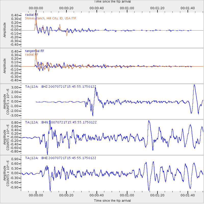
Signal To Noise
| Channel | StoN | STA | LTA |
| TA:J12A: :BHN:20070721T15:45:55.175012Z | 4.2279625 | 1.3623865E-7 | 3.2223245E-8 |
| TA:J12A: :BHE:20070721T15:45:55.175012Z | 2.7651224 | 9.352767E-8 | 3.3824058E-8 |
| TA:J12A: :BHZ:20070721T15:45:55.175012Z | 6.742331 | 3.9491334E-7 | 5.8572226E-8 |
| Arrivals |
| Ps | 4.5 SECOND |
| PpPs | 15 SECOND |
| PsPs/PpSs | 20 SECOND |


