You are here: Home > Network List > TA - USArray Transportable Network (new EarthScope stations) Stations List
> Station J12A Stokes Ranch, Hill City, ID, USA > Earthquake Result Viewer
J12A Stokes Ranch, Hill City, ID, USA - Earthquake Result Viewer

| Earthquake location: |
Near Coast Of Peru |
| Earthquake latitude/longitude: |
-15.7/-74.9 |
| Earthquake time(UTC): |
2007/06/28 (179) 08:44:48 GMT |
| Earthquake Depth: |
27 km |
| Earthquake Magnitude: |
5.5 MB, 5.3 MS, 5.8 MW, 5.8 MW |
| Earthquake Catalog/Contributor: |
WHDF/NEIC |
|
| Network: |
TA USArray Transportable Network (new EarthScope stations) |
| Station: |
J12A Stokes Ranch, Hill City, ID, USA |
| Lat/Lon: |
43.25 N/115.10 W |
| Elevation: |
1587 m |
|
| Distance: |
69.3 deg |
| Az: |
329.711 deg |
| Baz: |
138.326 deg |
| Ray Param: |
0.05572508 |
| Estimated Moho Depth: |
52.5 km |
| Estimated Crust Vp/Vs: |
2.10 |
| Assumed Crust Vp: |
6.291 km/s |
| Estimated Crust Vs: |
2.999 km/s |
| Estimated Crust Poisson's Ratio: |
0.35 |
|
| Radial Match: |
86.399506 % |
| Radial Bump: |
400 |
| Transverse Match: |
71.54717 % |
| Transverse Bump: |
400 |
| SOD ConfigId: |
2564 |
| Insert Time: |
2010-03-07 03:46:51.247 +0000 |
| GWidth: |
2.5 |
| Max Bumps: |
400 |
| Tol: |
0.001 |
|
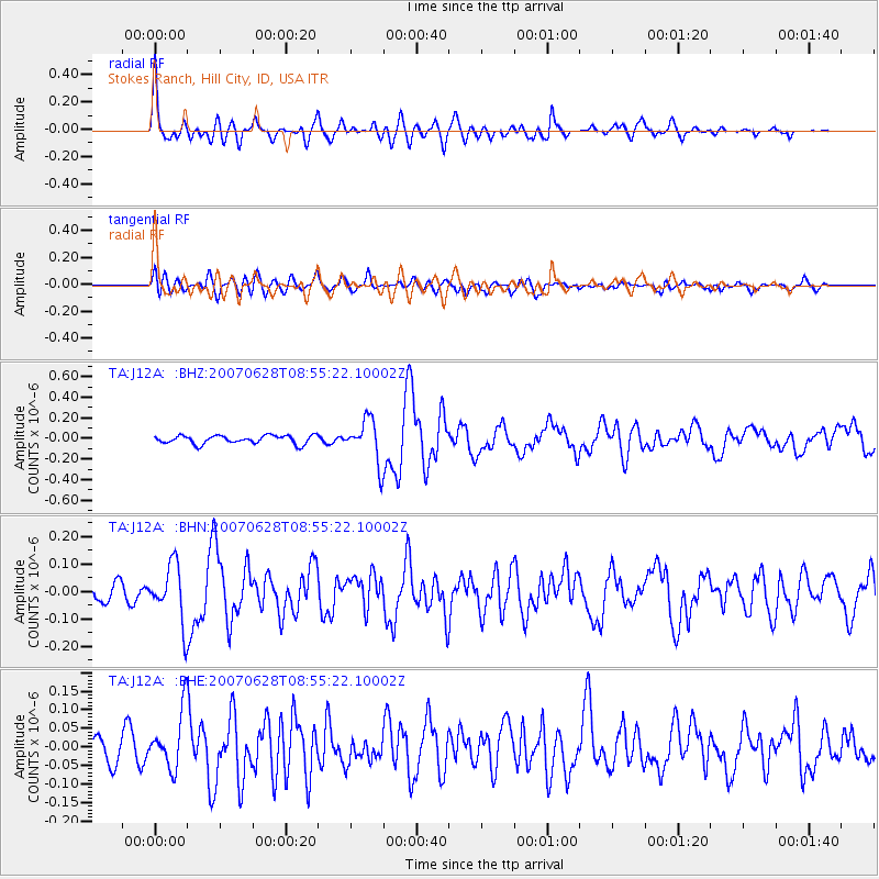
Signal To Noise
| Channel | StoN | STA | LTA |
| TA:J12A: :BHN:20070628T08:55:22.10002Z | 2.7812655 | 1.035144E-7 | 3.7218456E-8 |
| TA:J12A: :BHE:20070628T08:55:22.10002Z | 2.698702 | 7.68923E-8 | 2.8492325E-8 |
| TA:J12A: :BHZ:20070628T08:55:22.10002Z | 5.136251 | 2.0686475E-7 | 4.0275438E-8 |
| Arrivals |
| Ps | 9.4 SECOND |
| PpPs | 25 SECOND |
| PsPs/PpSs | 35 SECOND |


