You are here: Home > Network List > TA - USArray Transportable Network (new EarthScope stations) Stations List
> Station J12A Stokes Ranch, Hill City, ID, USA > Earthquake Result Viewer
J12A Stokes Ranch, Hill City, ID, USA - Earthquake Result Viewer
| Earthquake location: |
Mariana Islands |
| Earthquake latitude/longitude: |
21.0/144.7 |
| Earthquake time(UTC): |
2007/01/30 (030) 21:37:45 GMT |
| Earthquake Depth: |
30 km |
| Earthquake Magnitude: |
6.3 MB, 6.5 MS, 6.6 MW, 6.5 MW |
| Earthquake Catalog/Contributor: |
WHDF/NEIC |
|
| Network: |
TA USArray Transportable Network (new EarthScope stations) |
| Station: |
J12A Stokes Ranch, Hill City, ID, USA |
| Lat/Lon: |
43.25 N/115.10 W |
| Elevation: |
1587 m |
|
| Distance: |
83.0 deg |
| Az: |
46.429 deg |
| Baz: |
292.086 deg |
| Ray Param: |
0.04646825 |
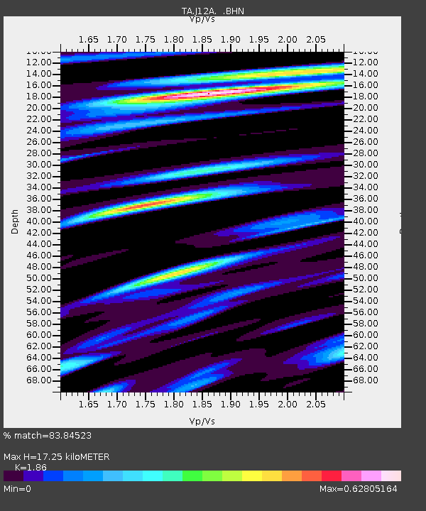
| Estimated Moho Depth: |
17.25 km |
| Estimated Crust Vp/Vs: |
1.86 |
| Assumed Crust Vp: |
6.291 km/s |
| Estimated Crust Vs: |
3.382 km/s |
| Estimated Crust Poisson's Ratio: |
0.30 |
|
| Radial Match: |
83.84523 % |
| Radial Bump: |
297 |
| Transverse Match: |
69.73438 % |
| Transverse Bump: |
400 |
| SOD ConfigId: |
2564 |
| Insert Time: |
2010-03-07 03:47:06.292 +0000 |
| GWidth: |
2.5 |
| Max Bumps: |
400 |
| Tol: |
0.001 |
|
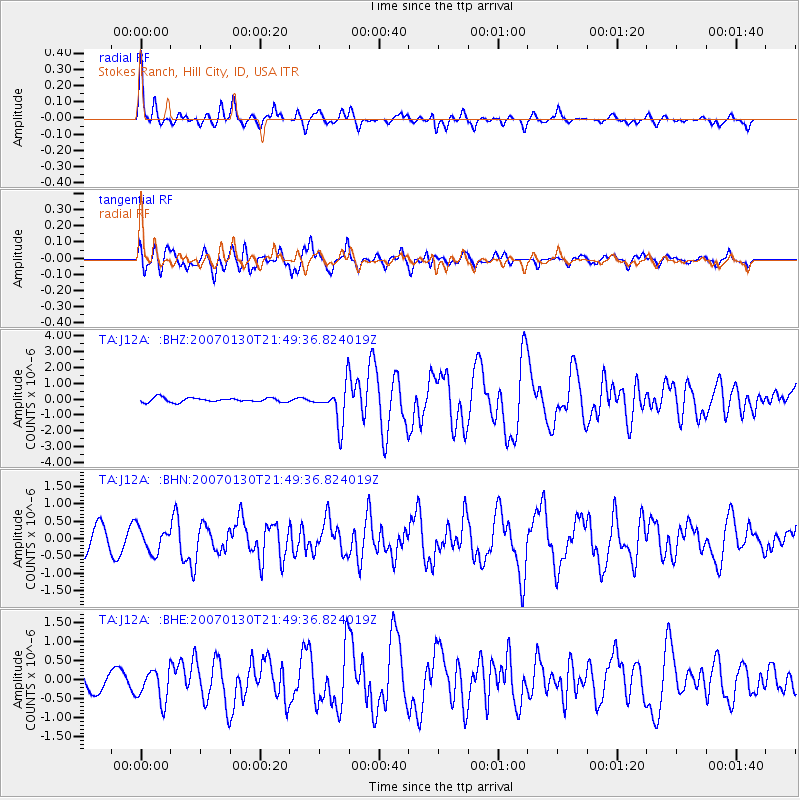
Signal To Noise
| Channel | StoN | STA | LTA |
| TA:J12A: :BHN:20070130T21:49:36.824019Z | 1.3745129 | 3.476159E-7 | 2.5290115E-7 |
| TA:J12A: :BHE:20070130T21:49:36.824019Z | 2.0341206 | 4.2666463E-7 | 2.0975384E-7 |
| TA:J12A: :BHZ:20070130T21:49:36.824019Z | 9.229405 | 1.2443016E-6 | 1.3481926E-7 |
| Arrivals |
| Ps | 2.4 SECOND |
| PpPs | 7.7 SECOND |
| PsPs/PpSs | 10 SECOND |


