You are here: Home > Network List > TA - USArray Transportable Network (new EarthScope stations) Stations List
> Station J04A Umpqua National Forest, Toketee, OR, USA > Earthquake Result Viewer
J04A Umpqua National Forest, Toketee, OR, USA - Earthquake Result Viewer
| Earthquake location: |
Komandorskiye Ostrova Region |
| Earthquake latitude/longitude: |
53.6/169.7 |
| Earthquake time(UTC): |
2007/07/29 (210) 04:54:36 GMT |
| Earthquake Depth: |
26 km |
| Earthquake Magnitude: |
6.0 MB, 5.5 MS, 5.9 MW, 5.8 MW |
| Earthquake Catalog/Contributor: |
WHDF/NEIC |
|
| Network: |
TA USArray Transportable Network (new EarthScope stations) |
| Station: |
J04A Umpqua National Forest, Toketee, OR, USA |
| Lat/Lon: |
43.24 N/122.11 W |
| Elevation: |
1952 m |
|
| Distance: |
44.8 deg |
| Az: |
74.488 deg |
| Baz: |
308.269 deg |
| Ray Param: |
0.07167769 |
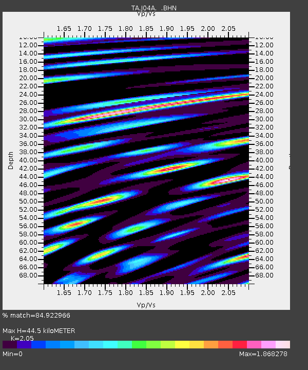
| Estimated Moho Depth: |
44.5 km |
| Estimated Crust Vp/Vs: |
2.05 |
| Assumed Crust Vp: |
6.522 km/s |
| Estimated Crust Vs: |
3.181 km/s |
| Estimated Crust Poisson's Ratio: |
0.34 |
|
| Radial Match: |
84.922966 % |
| Radial Bump: |
400 |
| Transverse Match: |
80.87831 % |
| Transverse Bump: |
400 |
| SOD ConfigId: |
2564 |
| Insert Time: |
2010-03-07 03:47:16.063 +0000 |
| GWidth: |
2.5 |
| Max Bumps: |
400 |
| Tol: |
0.001 |
|

Signal To Noise
| Channel | StoN | STA | LTA |
| TA:J04A: :BHN:20070729T05:02:17.225015Z | 1.9009594 | 4.032204E-7 | 2.1211416E-7 |
| TA:J04A: :BHE:20070729T05:02:17.225015Z | 1.9337349 | 3.1319865E-7 | 1.6196566E-7 |
| TA:J04A: :BHZ:20070729T05:02:17.225015Z | 3.888784 | 4.8852036E-7 | 1.2562292E-7 |
| Arrivals |
| Ps | 7.6 SECOND |
| PpPs | 20 SECOND |
| PsPs/PpSs | 27 SECOND |


