
Station TA J04A - Umpqua National Forest, Toketee, OR, USA
Network: TA - USArray Transportable Network (new EarthScope stations)
Nearby stations (2 deg radius)
| Station | Name | (Lat, Lon) | Start / End | Elevation |
| J04A | Umpqua National Forest, Toketee, OR, USA | (43.24, -122.11) | 2006-10-31 / 2499-01-01 | 2.0 km |
| Crust2 Type: | LC,continental arc, Cordilleras, 1.0 km seds. |
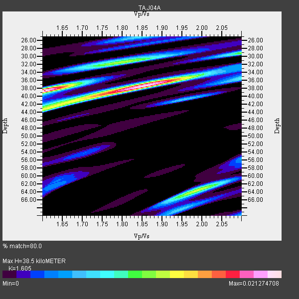
| Thickness Estimate: | 38 km |
| Thickness StdDev: | 9.9 km |
| Vp/Vs Estimate: | 1.61 |
| Vp/Vs StdDev: | 0.14 |
| Vs Estimate: | 4.063 km/s |
| Poisson's Ratio: | 0.18 |
| Peak Value: | 0.02 |
| Assumed Vp: | 6.522 km/s |
| Ps Weight: | 0.33333334 |
| PpPs Weight: | 0.33333334 |
| PsPs Weight: | 0.33333328 |
| Residual Complexity: | 0.900 |
| Nearby stations H: | +- |
| (2.0 deg) Vp/Vs: | +- |
3 with match > 90% ( 25.0 %) and 12 with match > 80% ( 100.0 %) out of 12.
Download stack as xyz text file.
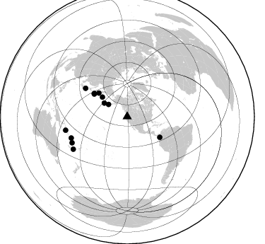
Azimuth Distribution of Events:
Prior Results for this Station
| Study | Thickness | Vp/Vs | Vp | Vs | Poissons Ratio | Extra |
| EARS | 38 km | 1.61 | 6.522 km/s | 4.063 km/s | 0.18 | |
| Crust2.0 | 37 km | 1.77 | 6.522 km/s | 3.676 km/s | 0.27 | LC,continental arc, Cordilleras, 1.0 km seds. |
| Global Maxima | 38 km | 1.61 | 6.522 km/s | 4.063 km/s | 0.18 | amp=0.021274708 |
| Local Maxima 1 | 37 km | 1.86 | 6.522 km/s | 3.516 km/s | 0.30 | amp=0.020786215 |
| Local Maxima 2 | 64 km | 1.99 | 6.522 km/s | 3.277 km/s | 0.33 | amp=0.012901048 |
| Local Maxima 3 | 31 km | 1.80 | 6.522 km/s | 3.618 km/s | 0.28 | amp=0.011923184 |
| Local Maxima 4 | 43 km | 1.62 | 6.522 km/s | 4.026 km/s | 0.19 | amp=0.011289755 |
| Predicted Arrivals for vertical incidence (zero ray parameter) | |
| Ps | 3.57 SECOND |
| PpPs | 15.38 SECOND |
| PsPs/PpSs | 18.95 SECOND |
Events Processed for this Station
Download zip of receiver functions as SAC
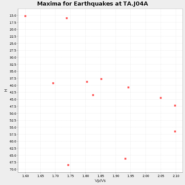
Plot maxima for each earthquake.
Events Used in the Stack
(12 events)| Radial Match | Distance | Baz | FERegion | Time | Lat/Lon | Depth | Magnitude |
| 94.630264 | 57.2 deg | 305.243 deg | Kuril Islands | 2006/11/15 11:14:13 GMT | (46.6, 153.3) | 10 km | 6.5 MB, 7.8 MS, 8.3 MW, 7.9 MW |
| 93.22821 | 56.6 deg | 304.365 deg | East Of Kuril Islands | 2007/01/13 04:23:21 GMT | (46.2, 154.5) | 10 km | 7.3 MB, 8.2 MS, 8.1 MW, 7.9 MW |
| 90.70847 | 37.8 deg | 300.638 deg | Andreanof Islands, Aleutian Is. | 2007/08/15 20:22:11 GMT | (50.3, -177.5) | 9.0 km | 6.3 MB, 6.2 MS, 6.4 MW, 5.9 ML |
| 89.85543 | 86.0 deg | 244.755 deg | Vanuatu Islands | 2007/07/15 09:27:34 GMT | (-15.4, 168.6) | 8.0 km | 6.0 MB, 5.8 MS, 6.1 MW, 6.0 MW |
| 89.34122 | 71.4 deg | 304.173 deg | Near West Coast Of Honshu, Japan | 2007/07/16 01:13:22 GMT | (37.5, 138.4) | 12 km | 6.5 MB, 6.4 MS, 6.6 MW, 6.5 MW |
| 89.1197 | 89.1 deg | 257.628 deg | Solomon Islands | 2007/04/01 20:39:56 GMT | (-8.5, 157.0) | 10 km | 6.8 MB, 7.9 MS, 8.1 MW, 7.7 ME |
| 87.50882 | 89.0 deg | 239.014 deg | Southeast Of Loyalty Islands | 2007/07/27 14:46:26 GMT | (-21.5, 170.9) | 10 km | 6.0 MB, 6.0 MS, 6.1 MW, 6.1 MW |
| 86.68244 | 54.4 deg | 122.303 deg | South Of Panama | 2007/03/18 02:11:05 GMT | (4.6, -78.5) | 8.0 km | 6.4 MB, 5.7 MS, 6.2 MW, 6.1 MW |
| 86.249825 | 52.3 deg | 309.806 deg | Kamchatka Peninsula, Russia | 2007/05/30 20:22:12 GMT | (52.1, 157.3) | 116 km | 6.4 MB, 6.4 MW, 6.4 MW |
| 86.062004 | 31.7 deg | 303.218 deg | Fox Islands, Aleutian Islands | 2007/07/15 13:08:00 GMT | (52.5, -168.0) | 10 km | 5.8 MB, 5.9 MS, 6.1 MW, 6.0 MW |
| 85.37409 | 84.7 deg | 249.155 deg | Santa Cruz Islands | 2007/08/12 12:05:19 GMT | (-11.4, 166.3) | 42 km | 5.8 MB, 5.7 MS, 6.0 MW, 6.0 MW |
| 84.922966 | 44.8 deg | 308.269 deg | Komandorskiye Ostrova Region | 2007/07/29 04:54:36 GMT | (53.6, 169.7) | 26 km | 6.0 MB, 5.5 MS, 5.9 MW, 5.8 MW |
Losers
(0 events)| Radial Match | Distance | Baz | FERegion | Time | Lat/Lon | Depth | Magnitude | Reason |
