You are here: Home > Network List > TA - USArray Transportable Network (new EarthScope stations) Stations List
> Station J04A Umpqua National Forest, Toketee, OR, USA > Earthquake Result Viewer
J04A Umpqua National Forest, Toketee, OR, USA - Earthquake Result Viewer
| Earthquake location: |
Southeast Of Loyalty Islands |
| Earthquake latitude/longitude: |
-21.5/170.9 |
| Earthquake time(UTC): |
2007/07/27 (208) 14:46:26 GMT |
| Earthquake Depth: |
10 km |
| Earthquake Magnitude: |
6.0 MB, 6.0 MS, 6.1 MW, 6.1 MW |
| Earthquake Catalog/Contributor: |
WHDF/NEIC |
|
| Network: |
TA USArray Transportable Network (new EarthScope stations) |
| Station: |
J04A Umpqua National Forest, Toketee, OR, USA |
| Lat/Lon: |
43.24 N/122.11 W |
| Elevation: |
1952 m |
|
| Distance: |
89.0 deg |
| Az: |
42.264 deg |
| Baz: |
239.014 deg |
| Ray Param: |
0.04220201 |
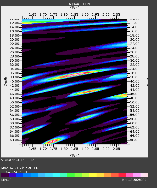
| Estimated Moho Depth: |
68.5 km |
| Estimated Crust Vp/Vs: |
1.74 |
| Assumed Crust Vp: |
6.522 km/s |
| Estimated Crust Vs: |
3.743 km/s |
| Estimated Crust Poisson's Ratio: |
0.25 |
|
| Radial Match: |
87.50882 % |
| Radial Bump: |
400 |
| Transverse Match: |
82.93757 % |
| Transverse Bump: |
400 |
| SOD ConfigId: |
2564 |
| Insert Time: |
2010-03-07 03:47:17.764 +0000 |
| GWidth: |
2.5 |
| Max Bumps: |
400 |
| Tol: |
0.001 |
|
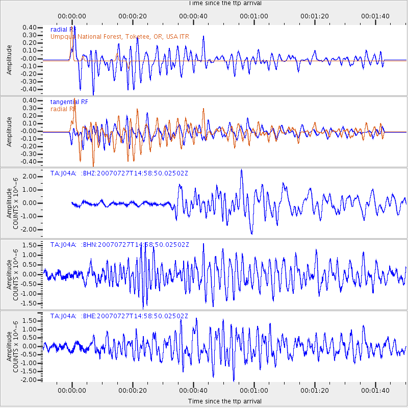
Signal To Noise
| Channel | StoN | STA | LTA |
| TA:J04A: :BHN:20070727T14:58:50.02502Z | 1.3233768 | 2.1332141E-7 | 1.6119476E-7 |
| TA:J04A: :BHE:20070727T14:58:50.02502Z | 1.2336013 | 2.1515977E-7 | 1.7441597E-7 |
| TA:J04A: :BHZ:20070727T14:58:50.02502Z | 3.0342476 | 3.5507873E-7 | 1.17023646E-7 |
| Arrivals |
| Ps | 8.0 SECOND |
| PpPs | 28 SECOND |
| PsPs/PpSs | 36 SECOND |


