You are here: Home > Network List > TA - USArray Transportable Network (new EarthScope stations) Stations List
> Station J04A Umpqua National Forest, Toketee, OR, USA > Earthquake Result Viewer
J04A Umpqua National Forest, Toketee, OR, USA - Earthquake Result Viewer
| Earthquake location: |
Near West Coast Of Honshu, Japan |
| Earthquake latitude/longitude: |
37.5/138.4 |
| Earthquake time(UTC): |
2007/07/16 (197) 01:13:22 GMT |
| Earthquake Depth: |
12 km |
| Earthquake Magnitude: |
6.5 MB, 6.4 MS, 6.6 MW, 6.5 MW |
| Earthquake Catalog/Contributor: |
WHDF/NEIC |
|
| Network: |
TA USArray Transportable Network (new EarthScope stations) |
| Station: |
J04A Umpqua National Forest, Toketee, OR, USA |
| Lat/Lon: |
43.24 N/122.11 W |
| Elevation: |
1952 m |
|
| Distance: |
71.4 deg |
| Az: |
49.513 deg |
| Baz: |
304.173 deg |
| Ray Param: |
0.054343134 |
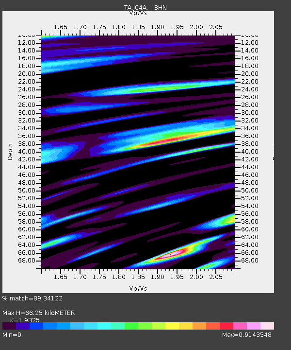
| Estimated Moho Depth: |
66.25 km |
| Estimated Crust Vp/Vs: |
1.93 |
| Assumed Crust Vp: |
6.522 km/s |
| Estimated Crust Vs: |
3.375 km/s |
| Estimated Crust Poisson's Ratio: |
0.32 |
|
| Radial Match: |
89.34122 % |
| Radial Bump: |
400 |
| Transverse Match: |
85.732475 % |
| Transverse Bump: |
400 |
| SOD ConfigId: |
2564 |
| Insert Time: |
2010-03-07 03:47:20.226 +0000 |
| GWidth: |
2.5 |
| Max Bumps: |
400 |
| Tol: |
0.001 |
|
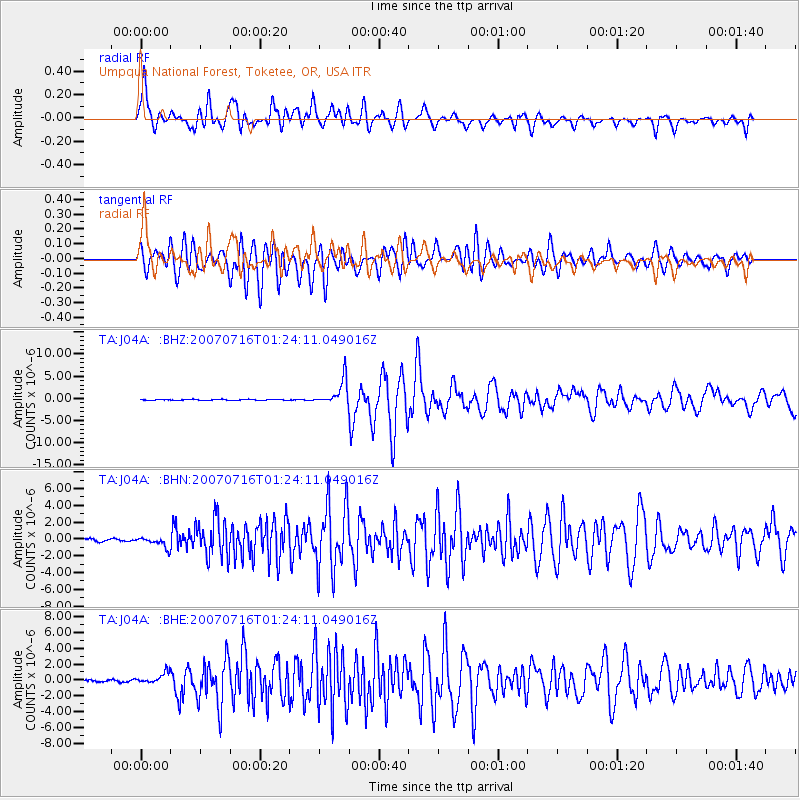
Signal To Noise
| Channel | StoN | STA | LTA |
| TA:J04A: :BHN:20070716T01:24:11.049016Z | 5.214382 | 6.0030345E-7 | 1.1512456E-7 |
| TA:J04A: :BHE:20070716T01:24:11.049016Z | 5.792395 | 6.935503E-7 | 1.1973464E-7 |
| TA:J04A: :BHZ:20070716T01:24:11.049016Z | 25.53809 | 2.8264326E-6 | 1.1067518E-7 |
| Arrivals |
| Ps | 9.8 SECOND |
| PpPs | 29 SECOND |
| PsPs/PpSs | 39 SECOND |


