You are here: Home > Network List > TA - USArray Transportable Network (new EarthScope stations) Stations List
> Station J04A Umpqua National Forest, Toketee, OR, USA > Earthquake Result Viewer
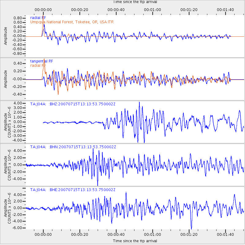
J04A Umpqua National Forest, Toketee, OR, USA - Earthquake Result Viewer
| Earthquake location: |
Fox Islands, Aleutian Islands |
| Earthquake latitude/longitude: |
52.5/-168.0 |
| Earthquake time(UTC): |
2007/07/15 (196) 13:08:00 GMT |
| Earthquake Depth: |
10 km |
| Earthquake Magnitude: |
5.8 MB, 5.9 MS, 6.1 MW, 6.0 MW |
| Earthquake Catalog/Contributor: |
WHDF/NEIC |
|
| Network: |
TA USArray Transportable Network (new EarthScope stations) |
| Station: |
J04A Umpqua National Forest, Toketee, OR, USA |
| Lat/Lon: |
43.24 N/122.11 W |
| Elevation: |
1952 m |
|
| Distance: |
31.7 deg |
| Az: |
88.316 deg |
| Baz: |
303.218 deg |
| Ray Param: |
0.078969054 |
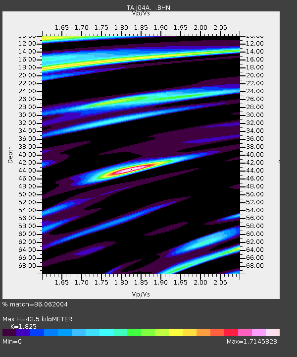
| Estimated Moho Depth: |
43.5 km |
| Estimated Crust Vp/Vs: |
1.83 |
| Assumed Crust Vp: |
6.522 km/s |
| Estimated Crust Vs: |
3.573 km/s |
| Estimated Crust Poisson's Ratio: |
0.29 |
|
| Radial Match: |
86.062004 % |
| Radial Bump: |
400 |
| Transverse Match: |
76.09942 % |
| Transverse Bump: |
400 |
| SOD ConfigId: |
2564 |
| Insert Time: |
2010-03-07 03:47:21.806 +0000 |
| GWidth: |
2.5 |
| Max Bumps: |
400 |
| Tol: |
0.001 |
|
Signal To Noise
| Channel | StoN | STA | LTA |
| TA:J04A: :BHN:20070715T13:13:53.750002Z | 1.1291386 | 1.6847392E-7 | 1.4920572E-7 |
| TA:J04A: :BHE:20070715T13:13:53.750002Z | 2.2397845 | 2.7801187E-7 | 1.2412438E-7 |
| TA:J04A: :BHZ:20070715T13:13:53.750002Z | 5.2322545 | 4.601341E-7 | 8.7941835E-8 |
| Arrivals |
| Ps | 6.0 SECOND |
| PpPs | 17 SECOND |
| PsPs/PpSs | 23 SECOND |


