You are here: Home > Network List > TA - USArray Transportable Network (new EarthScope stations) Stations List
> Station J04A Umpqua National Forest, Toketee, OR, USA > Earthquake Result Viewer
J04A Umpqua National Forest, Toketee, OR, USA - Earthquake Result Viewer
| Earthquake location: |
South Of Panama |
| Earthquake latitude/longitude: |
4.6/-78.5 |
| Earthquake time(UTC): |
2007/03/18 (077) 02:11:05 GMT |
| Earthquake Depth: |
8.0 km |
| Earthquake Magnitude: |
6.4 MB, 5.7 MS, 6.2 MW, 6.1 MW |
| Earthquake Catalog/Contributor: |
WHDF/NEIC |
|
| Network: |
TA USArray Transportable Network (new EarthScope stations) |
| Station: |
J04A Umpqua National Forest, Toketee, OR, USA |
| Lat/Lon: |
43.24 N/122.11 W |
| Elevation: |
1952 m |
|
| Distance: |
54.4 deg |
| Az: |
321.71 deg |
| Baz: |
122.303 deg |
| Ray Param: |
0.065456636 |
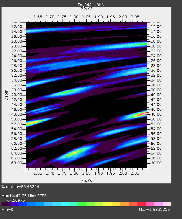
| Estimated Moho Depth: |
47.25 km |
| Estimated Crust Vp/Vs: |
2.10 |
| Assumed Crust Vp: |
6.522 km/s |
| Estimated Crust Vs: |
3.109 km/s |
| Estimated Crust Poisson's Ratio: |
0.35 |
|
| Radial Match: |
86.68244 % |
| Radial Bump: |
400 |
| Transverse Match: |
87.7534 % |
| Transverse Bump: |
400 |
| SOD ConfigId: |
2564 |
| Insert Time: |
2010-03-07 03:47:29.265 +0000 |
| GWidth: |
2.5 |
| Max Bumps: |
400 |
| Tol: |
0.001 |
|
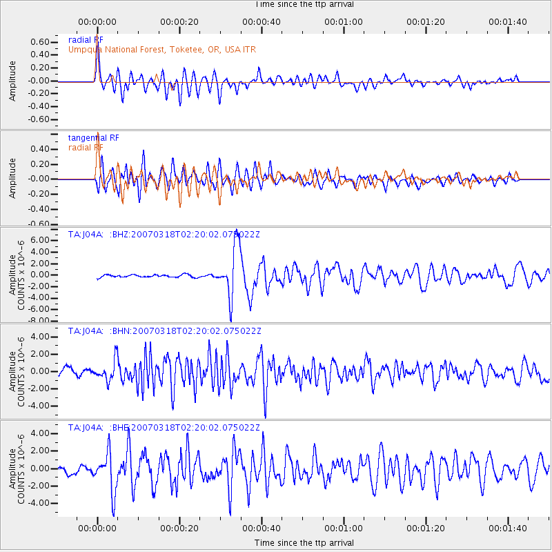
Signal To Noise
| Channel | StoN | STA | LTA |
| TA:J04A: :BHN:20070318T02:20:02.075022Z | 2.481066 | 1.1928643E-6 | 4.80787E-7 |
| TA:J04A: :BHE:20070318T02:20:02.075022Z | 6.6225743 | 2.2990819E-6 | 3.4715833E-7 |
| TA:J04A: :BHZ:20070318T02:20:02.075022Z | 20.467665 | 4.4906697E-6 | 2.1940315E-7 |
| Arrivals |
| Ps | 8.3 SECOND |
| PpPs | 21 SECOND |
| PsPs/PpSs | 30 SECOND |


