You are here: Home > Network List > TA - USArray Transportable Network (new EarthScope stations) Stations List
> Station O09A Fish Creek Ranch, Battle Mountain, NV, USA > Earthquake Result Viewer
O09A Fish Creek Ranch, Battle Mountain, NV, USA - Earthquake Result Viewer
| Earthquake location: |
South Of Fiji Islands |
| Earthquake latitude/longitude: |
-26.0/-177.5 |
| Earthquake time(UTC): |
2007/12/09 (343) 07:28:20 GMT |
| Earthquake Depth: |
152 km |
| Earthquake Magnitude: |
7.0 MB, 7.8 MW, 7.7 MW |
| Earthquake Catalog/Contributor: |
WHDF/NEIC |
|
| Network: |
TA USArray Transportable Network (new EarthScope stations) |
| Station: |
O09A Fish Creek Ranch, Battle Mountain, NV, USA |
| Lat/Lon: |
40.17 N/117.19 W |
| Elevation: |
1492 m |
|
| Distance: |
86.5 deg |
| Az: |
41.837 deg |
| Baz: |
231.574 deg |
| Ray Param: |
0.043672133 |
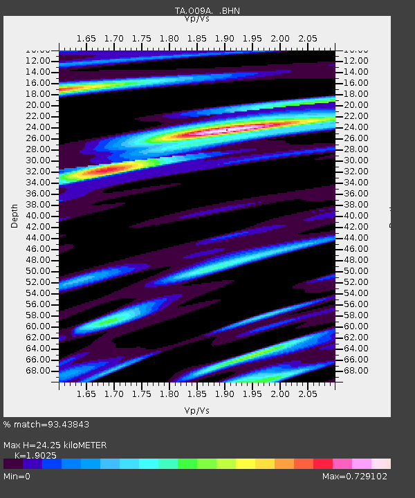
| Estimated Moho Depth: |
24.25 km |
| Estimated Crust Vp/Vs: |
1.90 |
| Assumed Crust Vp: |
6.276 km/s |
| Estimated Crust Vs: |
3.299 km/s |
| Estimated Crust Poisson's Ratio: |
0.31 |
|
| Radial Match: |
93.43843 % |
| Radial Bump: |
400 |
| Transverse Match: |
75.79007 % |
| Transverse Bump: |
400 |
| SOD ConfigId: |
2564 |
| Insert Time: |
2010-03-07 03:49:31.453 +0000 |
| GWidth: |
2.5 |
| Max Bumps: |
400 |
| Tol: |
0.001 |
|

Signal To Noise
| Channel | StoN | STA | LTA |
| TA:O09A: :BHN:20071209T07:40:15.174004Z | 1.8530813 | 3.2181407E-7 | 1.7366429E-7 |
| TA:O09A: :BHE:20071209T07:40:15.174004Z | 2.1272743 | 4.715903E-7 | 2.2168759E-7 |
| TA:O09A: :BHZ:20071209T07:40:15.174004Z | 6.6716347 | 1.1887753E-6 | 1.7818351E-7 |
| Arrivals |
| Ps | 3.6 SECOND |
| PpPs | 11 SECOND |
| PsPs/PpSs | 15 SECOND |


