
Station TA O09A - Fish Creek Ranch, Battle Mountain, NV, USA
Network: TA - USArray Transportable Network (new EarthScope stations)
Nearby stations (2 deg radius)
| Station | Name | (Lat, Lon) | Start / End | Elevation |
| O09A | Fish Creek Ranch, Battle Mountain, NV, USA | (40.17, -117.19) | 2006-04-22 / 2499-01-01 | 1.5 km |
| Crust2 Type: | M5,extended crust, 0.5 km seds. |
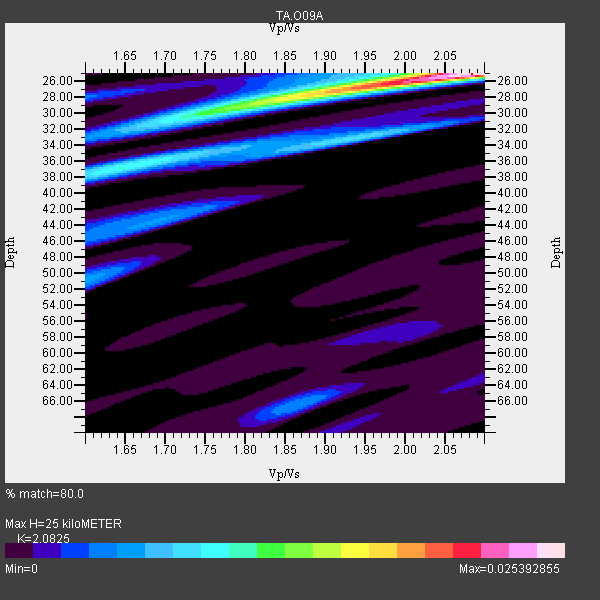
| Thickness Estimate: | 25 km |
| Thickness StdDev: | 0.2 km |
| Vp/Vs Estimate: | 2.08 |
| Vp/Vs StdDev: | 0.02 |
| Vs Estimate: | 3.014 km/s |
| Poisson's Ratio: | 0.35 |
| Peak Value: | 0.03 |
| Assumed Vp: | 6.276 km/s |
| Ps Weight: | 0.33333334 |
| PpPs Weight: | 0.33333334 |
| PsPs Weight: | 0.33333328 |
| Residual Complexity: | 0.633 |
| Nearby stations H: | +- |
| (2.0 deg) Vp/Vs: | +- |
19 with match > 90% ( 35.849056 %) and 53 with match > 80% ( 100.0 %) out of 53.
Download stack as xyz text file.
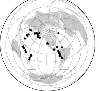
Azimuth Distribution of Events:
Prior Results for this Station
| Study | Thickness | Vp/Vs | Vp | Vs | Poissons Ratio | Extra |
| EARS | 25 km | 2.08 | 6.276 km/s | 3.014 km/s | 0.35 | |
| Crust2.0 | 31 km | 1.78 | 6.276 km/s | 3.529 km/s | 0.27 | M5,extended crust, 0.5 km seds. |
| Global Maxima | 25 km | 2.08 | 6.276 km/s | 3.014 km/s | 0.35 | amp=0.025392855 |
| Local Maxima 1 | 29 km | 1.81 | 6.276 km/s | 3.477 km/s | 0.28 | amp=0.012018493 |
| Local Maxima 2 | 37 km | 1.65 | 6.276 km/s | 3.809 km/s | 0.21 | amp=0.009521708 |
| Local Maxima 3 | 33 km | 1.95 | 6.276 km/s | 3.227 km/s | 0.32 | amp=0.0059959204 |
| Local Maxima 4 | 50 km | 1.61 | 6.276 km/s | 3.91 km/s | 0.18 | amp=0.0052668117 |
| Predicted Arrivals for vertical incidence (zero ray parameter) | |
| Ps | 4.31 SECOND |
| PpPs | 12.28 SECOND |
| PsPs/PpSs | 16.59 SECOND |
Events Processed for this Station
Download zip of receiver functions as SAC
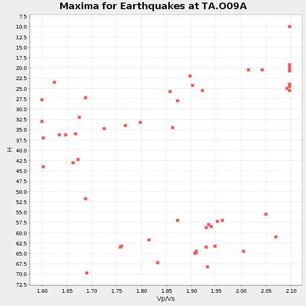
Plot maxima for each earthquake.
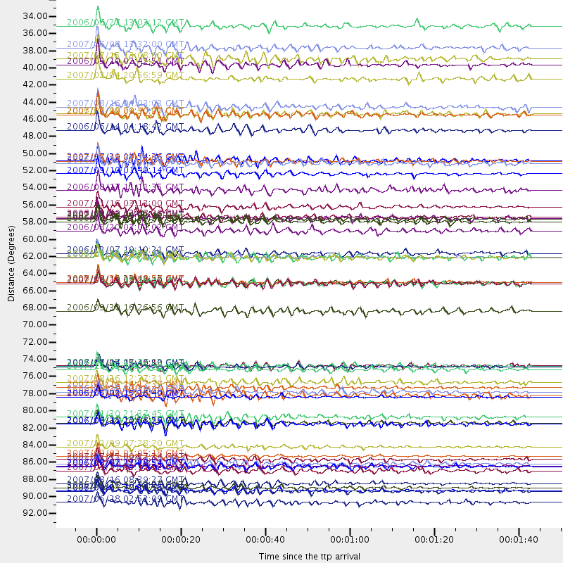
Events Used in the Stack
(53 events)| Radial Match | Distance | Baz | FERegion | Time | Lat/Lon | Depth | Magnitude |
| 96.49935 | 62.0 deg | 308.645 deg | Kuril Islands | 2006/11/15 11:14:13 GMT | (46.6, 153.3) | 10 km | 6.5 MB, 7.8 MS, 8.3 MW, 7.9 MW |
| 96.02858 | 87.7 deg | 252.869 deg | Santa Cruz Islands | 2007/09/02 01:05:18 GMT | (-11.6, 165.8) | 35 km | 5.9 MB, 7.3 MS, 7.2 MW, 6.9 ME |
| 95.96645 | 80.1 deg | 233.047 deg | Tonga Islands | 2006/05/03 15:26:40 GMT | (-20.2, -174.1) | 55 km | 7.2 MB, 7.8 MS, 7.9 MW, 7.9 MW |
| 95.218834 | 76.1 deg | 135.47 deg | Northern Chile | 2007/11/14 15:40:50 GMT | (-22.2, -69.9) | 40 km | 6.7 MB, 7.4 MS, 7.7 MW, 7.4 ME |
| 95.09121 | 91.8 deg | 228.869 deg | Kermadec Islands Region | 2006/05/16 10:39:23 GMT | (-31.8, -179.3) | 152 km | 6.8 MB, 7.4 MW, 7.4 MW |
| 94.71579 | 92.2 deg | 260.849 deg | Solomon Islands | 2007/04/01 20:39:56 GMT | (-8.5, 157.0) | 10 km | 6.8 MB, 7.9 MS, 8.1 MW, 7.7 ME |
| 94.15444 | 65.3 deg | 135.802 deg | Near Coast Of Peru | 2007/08/15 23:40:57 GMT | (-13.4, -76.6) | 39 km | 6.7 MB, 7.9 MS, 8.0 MW, 7.5 ME |
| 94.06742 | 51.2 deg | 125.922 deg | Near West Coast Of Colombia | 2007/09/10 01:49:14 GMT | (3.0, -78.0) | 31 km | 6.1 MB, 6.7 MS, 6.8 MW |
| 93.986694 | 89.0 deg | 248.463 deg | Vanuatu Islands | 2006/08/07 22:18:54 GMT | (-15.8, 167.8) | 141 km | 6.0 MB, 6.8 MW, 6.8 MW |
| 93.98078 | 49.7 deg | 125.172 deg | South Of Panama | 2007/03/18 02:11:05 GMT | (4.6, -78.5) | 8.0 km | 6.4 MB, 5.7 MS, 6.2 MW, 6.1 MW |
| 93.43843 | 86.5 deg | 231.574 deg | South Of Fiji Islands | 2007/12/09 07:28:20 GMT | (-26.0, -177.5) | 152 km | 7.0 MB, 7.8 MW, 7.7 MW |
| 93.361565 | 65.3 deg | 135.911 deg | Near Coast Of Peru | 2006/10/20 10:48:56 GMT | (-13.5, -76.7) | 23 km | 5.9 MB, 6.6 MS, 6.7 MW, 6.6 MW |
| 93.174736 | 55.5 deg | 129.761 deg | Peru-Ecuador Border Region | 2007/11/16 03:13:00 GMT | (-2.3, -77.8) | 123 km | 6.3 MB, 6.8 MW, 6.7 MW |
| 93.16069 | 89.0 deg | 248.674 deg | Vanuatu Islands | 2007/08/01 17:08:51 GMT | (-15.6, 167.7) | 120 km | 6.2 MB, 7.2 MW, 7.2 MW |
| 92.93499 | 36.5 deg | 307.054 deg | Fox Islands, Aleutian Islands | 2007/07/15 13:08:00 GMT | (52.5, -168.0) | 10 km | 5.8 MB, 5.9 MS, 6.1 MW, 6.0 MW |
| 91.81109 | 91.2 deg | 258.263 deg | Solomon Islands | 2007/08/16 08:39:27 GMT | (-9.8, 159.5) | 10 km | 6.1 MB, 6.7 MS, 6.4 MW |
| 91.561386 | 88.2 deg | 248.234 deg | Vanuatu Islands | 2007/07/15 09:27:34 GMT | (-15.4, 168.6) | 8.0 km | 6.0 MB, 5.8 MS, 6.1 MW, 6.0 MW |
| 90.72196 | 37.2 deg | 307.145 deg | Fox Islands, Aleutian Islands | 2006/05/10 02:42:51 GMT | (52.5, -169.3) | 18 km | 6.1 MB, 6.2 MS, 6.4 MW, 6.3 MW |
| 90.04057 | 43.6 deg | 306.437 deg | Andreanof Islands, Aleutian Is. | 2007/12/19 09:30:27 GMT | (51.4, -179.5) | 29 km | 6.4 MB, 7.1 MS, 7.1 MW, 7.0 MW |
| 89.77908 | 57.4 deg | 311.833 deg | Near East Coast Of Kamchatka | 2006/08/24 21:50:36 GMT | (51.1, 157.5) | 43 km | 5.9 MB, 6.2 MS, 6.5 MW, 6.5 MW |
| 89.68279 | 83.5 deg | 293.152 deg | Volcano Islands, Japan Region | 2007/09/28 13:38:59 GMT | (22.0, 142.7) | 276 km | 6.7 MB, 7.4 MW, 7.4 MW |
| 89.38615 | 83.6 deg | 308.301 deg | Kyushu, Japan | 2006/06/11 20:01:26 GMT | (33.1, 131.1) | 140 km | 5.9 MB, 6.3 MW, 6.3 MW |
| 89.22889 | 45.6 deg | 307.577 deg | Rat Islands, Aleutian Islands | 2006/06/14 04:18:42 GMT | (51.8, 177.1) | 14 km | 5.9 MB, 6.4 MS, 6.4 MW, 6.4 MW |
| 88.99883 | 35.0 deg | 131.081 deg | Near Coast Of Guatemala | 2007/06/08 13:32:00 GMT | (13.8, -90.8) | 48 km | 5.5 MB, 5.4 MS, 5.8 MW, 5.8 MW |
| 88.7669 | 49.6 deg | 311.523 deg | Komandorskiye Ostrova Region | 2007/07/29 04:54:36 GMT | (53.6, 169.7) | 26 km | 6.0 MB, 5.5 MS, 5.9 MW, 5.8 MW |
| 87.718475 | 62.1 deg | 308.535 deg | Kuril Islands | 2006/10/01 09:06:02 GMT | (46.5, 153.2) | 19 km | 6.1 MB, 6.4 MS, 6.6 MW, 6.5 MW |
| 87.35973 | 76.5 deg | 136.141 deg | Near Coast Of Northern Chile | 2007/11/15 15:05:58 GMT | (-22.9, -70.2) | 26 km | 6.1 MB, 6.6 MS, 6.8 MW, 6.6 MW |
| 87.305374 | 57.0 deg | 46.835 deg | Northern Mid-Atlantic Ridge | 2007/05/23 04:41:46 GMT | (52.4, -31.8) | 10 km | 5.6 MS, 5.4 MB, 5.7 MW, 5.6 MW |
| 87.218025 | 82.7 deg | 291.132 deg | Mariana Islands | 2007/01/30 21:37:45 GMT | (21.0, 144.7) | 30 km | 6.3 MB, 6.5 MS, 6.6 MW, 6.5 MW |
| 87.13404 | 61.5 deg | 307.777 deg | East Of Kuril Islands | 2006/12/07 19:10:21 GMT | (46.2, 154.4) | 16 km | 6.3 MB, 6.1 MS, 6.3 MW, 6.3 MW |
| 87.070465 | 78.8 deg | 308.904 deg | Sea Of Japan | 2007/07/16 14:17:37 GMT | (36.8, 134.9) | 350 km | 6.2 MB, 6.8 MW, 6.8 MW |
| 87.027855 | 88.7 deg | 282.487 deg | South Of Mariana Islands | 2007/09/30 02:08:30 GMT | (10.5, 145.7) | 14 km | 6.4 MB, 7.1 MS, 6.9 MW, 6.9 MW |
| 86.946945 | 43.5 deg | 306.19 deg | Andreanof Islands, Aleutian Is. | 2006/07/08 20:40:00 GMT | (51.2, -179.3) | 22 km | 6.2 MB, 6.4 MS, 6.6 MW, 6.6 MW |
| 86.78958 | 65.5 deg | 135.958 deg | Near Coast Of Peru | 2007/08/19 01:22:40 GMT | (-13.6, -76.6) | 26 km | 5.9 MB, 5.4 MS, 5.8 MW, 5.5 ML |
| 85.93725 | 89.6 deg | 229.379 deg | Kermadec Islands, New Zealand | 2007/01/31 03:15:52 GMT | (-29.8, -178.0) | 34 km | 6.1 MB, 6.3 MS, 6.5 MW, 6.4 MW |
| 85.56373 | 76.1 deg | 233.874 deg | Samoa Islands Region | 2006/09/28 06:22:09 GMT | (-16.6, -172.0) | 28 km | 6.5 MB, 6.6 MS, 6.9 MW, 6.7 MW |
| 84.75931 | 32.2 deg | 134.789 deg | Off Coast Of Chiapas, Mexico | 2006/06/27 13:03:12 GMT | (15.0, -94.2) | 29 km | 5.4 MB, 5.5 MS, 5.8 MW, 5.8 MW |
| 84.68388 | 56.8 deg | 104.847 deg | Trinidad | 2006/09/29 13:08:26 GMT | (10.9, -61.8) | 53 km | 5.9 MB, 5.4 MS, 6.1 MW, 6.0 MW |
| 84.47875 | 65.4 deg | 135.931 deg | Near Coast Of Peru | 2007/08/17 13:18:13 GMT | (-13.6, -76.6) | 48 km | 5.6 MB, 5.6 MS, 5.9 MW |
| 84.377426 | 53.4 deg | 315.72 deg | Near East Coast Of Kamchatka | 2006/08/17 11:11:35 GMT | (55.6, 161.7) | 55 km | 6.1 MB, 5.7 MW, 5.7 MW |
| 83.838806 | 92.2 deg | 263.122 deg | Solomon Islands | 2006/09/01 10:18:51 GMT | (-6.8, 155.5) | 38 km | 6.3 MB, 6.7 MS, 6.8 MW, 6.7 MW |
| 83.83605 | 49.9 deg | 321.298 deg | Eastern Siberia, Russia | 2006/05/22 11:12:00 GMT | (60.8, 165.7) | 16 km | 6.0 MB, 6.7 MS, 6.6 MW, 6.5 MW |
| 83.58267 | 76.0 deg | 235.959 deg | Tonga Islands | 2006/07/07 07:26:12 GMT | (-15.2, -173.6) | 35 km | 5.7 MB, 5.9 MS, 6.0 MW, 6.0 MW |
| 82.48534 | 79.9 deg | 295.508 deg | Bonin Islands, Japan Region | 2006/08/06 18:16:40 GMT | (26.1, 144.0) | 23 km | 6.0 MB, 5.6 MS, 5.8 MW, 5.8 MW |
| 81.80425 | 58.6 deg | 310.785 deg | Kuril Islands | 2006/08/20 03:01:02 GMT | (49.8, 156.4) | 26 km | 5.8 MB, 5.7 MS, 6.0 MW, 5.9 MW |
| 81.45871 | 39.0 deg | 110.532 deg | Cuba Region | 2007/02/04 20:56:59 GMT | (19.4, -78.5) | 10 km | 5.7 MB, 5.9 MS, 6.2 MW, 6.2 MW |
| 81.3985 | 93.7 deg | 262.761 deg | Solomon Islands | 2007/06/28 02:52:09 GMT | (-8.0, 154.6) | 10 km | 6.3 MB, 6.7 MS, 6.7 MW, 6.7 MW |
| 81.3857 | 79.4 deg | 134.591 deg | Chile-Argentina Border Region | 2006/08/25 00:44:46 GMT | (-24.4, -67.0) | 184 km | 5.9 MB, 6.6 MW, 6.6 MW |
| 81.04883 | 78.2 deg | 235.012 deg | Tonga Islands | 2007/08/26 12:37:31 GMT | (-17.5, -174.3) | 127 km | 5.9 MB, 6.1 MW |
| 80.93438 | 42.6 deg | 304.496 deg | Andreanof Islands, Aleutian Is. | 2007/08/16 04:03:03 GMT | (50.2, -177.6) | 15 km | 5.8 MB |
| 80.59504 | 68.9 deg | 134.132 deg | Southern Peru | 2006/09/30 16:26:56 GMT | (-15.6, -73.2) | 107 km | 5.6 MB, 6.0 MW, 5.9 MW |
| 80.27802 | 57.1 deg | 312.974 deg | Kamchatka Peninsula, Russia | 2007/05/30 20:22:12 GMT | (52.1, 157.3) | 116 km | 6.4 MB, 6.4 MW, 6.4 MW |
| 80.03809 | 62.0 deg | 130.353 deg | Peru-Brazil Border Region | 2007/07/12 05:23:49 GMT | (-7.9, -74.4) | 152 km | 5.9 MB, 6.1 MW, 6.0 MW |
Losers
(0 events)| Radial Match | Distance | Baz | FERegion | Time | Lat/Lon | Depth | Magnitude | Reason |
