You are here: Home > Network List > TA - USArray Transportable Network (new EarthScope stations) Stations List
> Station O09A Fish Creek Ranch, Battle Mountain, NV, USA > Earthquake Result Viewer
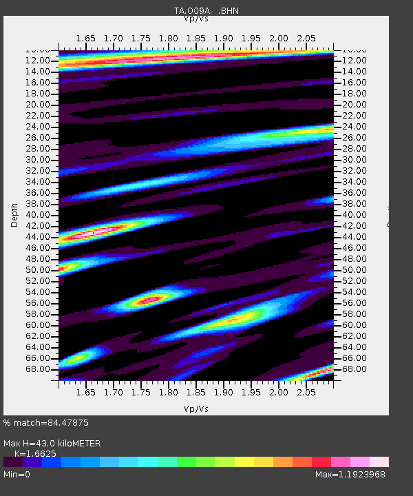
O09A Fish Creek Ranch, Battle Mountain, NV, USA - Earthquake Result Viewer
| Earthquake location: |
Near Coast Of Peru |
| Earthquake latitude/longitude: |
-13.6/-76.6 |
| Earthquake time(UTC): |
2007/08/17 (229) 13:18:13 GMT |
| Earthquake Depth: |
48 km |
| Earthquake Magnitude: |
5.6 MB, 5.6 MS, 5.9 MW |
| Earthquake Catalog/Contributor: |
WHDF/NEIC |
|
| Network: |
TA USArray Transportable Network (new EarthScope stations) |
| Station: |
O09A Fish Creek Ranch, Battle Mountain, NV, USA |
| Lat/Lon: |
40.17 N/117.19 W |
| Elevation: |
1492 m |
|
| Distance: |
65.4 deg |
| Az: |
326.76 deg |
| Baz: |
135.931 deg |
| Ray Param: |
0.0581677 |
| Estimated Moho Depth: |
43.0 km |
| Estimated Crust Vp/Vs: |
1.66 |
| Assumed Crust Vp: |
6.276 km/s |
| Estimated Crust Vs: |
3.775 km/s |
| Estimated Crust Poisson's Ratio: |
0.22 |
|
| Radial Match: |
84.47875 % |
| Radial Bump: |
400 |
| Transverse Match: |
73.30982 % |
| Transverse Bump: |
400 |
| SOD ConfigId: |
2564 |
| Insert Time: |
2010-03-07 03:49:54.067 +0000 |
| GWidth: |
2.5 |
| Max Bumps: |
400 |
| Tol: |
0.001 |
|

Signal To Noise
| Channel | StoN | STA | LTA |
| TA:O09A: :BHN:20070817T13:28:20.300017Z | 3.9464438 | 2.3555268E-7 | 5.968732E-8 |
| TA:O09A: :BHE:20070817T13:28:20.300017Z | 2.839998 | 1.5399252E-7 | 5.4222756E-8 |
| TA:O09A: :BHZ:20070817T13:28:20.300017Z | 8.959572 | 6.519212E-7 | 7.276253E-8 |
| Arrivals |
| Ps | 4.7 SECOND |
| PpPs | 17 SECOND |
| PsPs/PpSs | 22 SECOND |


