You are here: Home > Network List > TA - USArray Transportable Network (new EarthScope stations) Stations List
> Station O09A Fish Creek Ranch, Battle Mountain, NV, USA > Earthquake Result Viewer
O09A Fish Creek Ranch, Battle Mountain, NV, USA - Earthquake Result Viewer
| Earthquake location: |
Cuba Region |
| Earthquake latitude/longitude: |
19.4/-78.5 |
| Earthquake time(UTC): |
2007/02/04 (035) 20:56:59 GMT |
| Earthquake Depth: |
10 km |
| Earthquake Magnitude: |
5.7 MB, 5.9 MS, 6.2 MW, 6.2 MW |
| Earthquake Catalog/Contributor: |
WHDF/NEIC |
|
| Network: |
TA USArray Transportable Network (new EarthScope stations) |
| Station: |
O09A Fish Creek Ranch, Battle Mountain, NV, USA |
| Lat/Lon: |
40.17 N/117.19 W |
| Elevation: |
1492 m |
|
| Distance: |
39.0 deg |
| Az: |
310.527 deg |
| Baz: |
110.532 deg |
| Ray Param: |
0.07521125 |
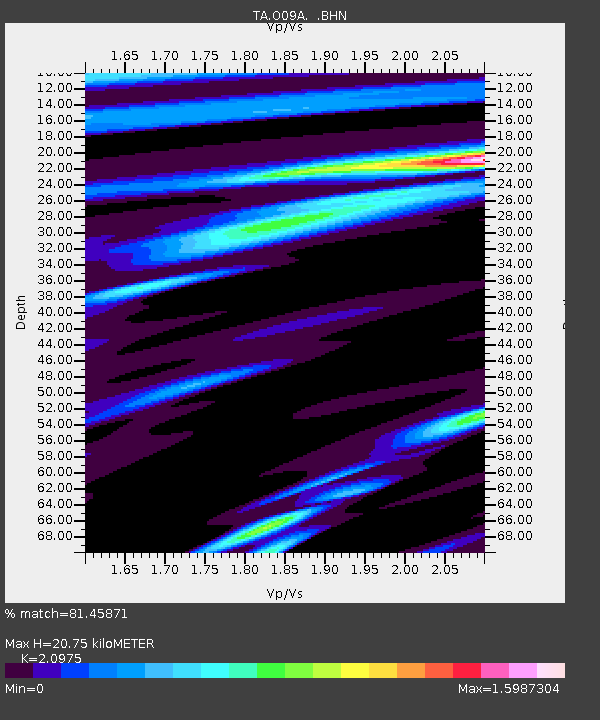
| Estimated Moho Depth: |
20.75 km |
| Estimated Crust Vp/Vs: |
2.10 |
| Assumed Crust Vp: |
6.276 km/s |
| Estimated Crust Vs: |
2.992 km/s |
| Estimated Crust Poisson's Ratio: |
0.35 |
|
| Radial Match: |
81.45871 % |
| Radial Bump: |
400 |
| Transverse Match: |
48.97559 % |
| Transverse Bump: |
400 |
| SOD ConfigId: |
2564 |
| Insert Time: |
2010-03-07 03:50:22.483 +0000 |
| GWidth: |
2.5 |
| Max Bumps: |
400 |
| Tol: |
0.001 |
|

Signal To Noise
| Channel | StoN | STA | LTA |
| TA:O09A: :BHN:20070204T21:03:55.149012Z | 0.723853 | 1.5244731E-7 | 2.1060535E-7 |
| TA:O09A: :BHE:20070204T21:03:55.149012Z | 1.57113 | 5.182971E-7 | 3.298881E-7 |
| TA:O09A: :BHZ:20070204T21:03:55.149012Z | 2.7428622 | 5.2101484E-7 | 1.8995297E-7 |
| Arrivals |
| Ps | 3.8 SECOND |
| PpPs | 9.7 SECOND |
| PsPs/PpSs | 14 SECOND |


