You are here: Home > Network List > TA - USArray Transportable Network (new EarthScope stations) Stations List
> Station O09A Fish Creek Ranch, Battle Mountain, NV, USA > Earthquake Result Viewer
O09A Fish Creek Ranch, Battle Mountain, NV, USA - Earthquake Result Viewer
| Earthquake location: |
East Of Kuril Islands |
| Earthquake latitude/longitude: |
46.2/154.4 |
| Earthquake time(UTC): |
2006/12/07 (341) 19:10:21 GMT |
| Earthquake Depth: |
16 km |
| Earthquake Magnitude: |
6.3 MB, 6.1 MS, 6.3 MW, 6.3 MW |
| Earthquake Catalog/Contributor: |
WHDF/NEIC |
|
| Network: |
TA USArray Transportable Network (new EarthScope stations) |
| Station: |
O09A Fish Creek Ranch, Battle Mountain, NV, USA |
| Lat/Lon: |
40.17 N/117.19 W |
| Elevation: |
1492 m |
|
| Distance: |
61.5 deg |
| Az: |
60.606 deg |
| Baz: |
307.777 deg |
| Ray Param: |
0.06079509 |
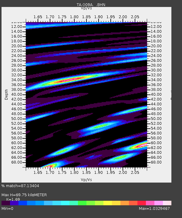
| Estimated Moho Depth: |
69.75 km |
| Estimated Crust Vp/Vs: |
1.69 |
| Assumed Crust Vp: |
6.276 km/s |
| Estimated Crust Vs: |
3.713 km/s |
| Estimated Crust Poisson's Ratio: |
0.23 |
|
| Radial Match: |
87.13404 % |
| Radial Bump: |
400 |
| Transverse Match: |
79.93509 % |
| Transverse Bump: |
400 |
| SOD ConfigId: |
2564 |
| Insert Time: |
2010-03-07 03:50:27.212 +0000 |
| GWidth: |
2.5 |
| Max Bumps: |
400 |
| Tol: |
0.001 |
|
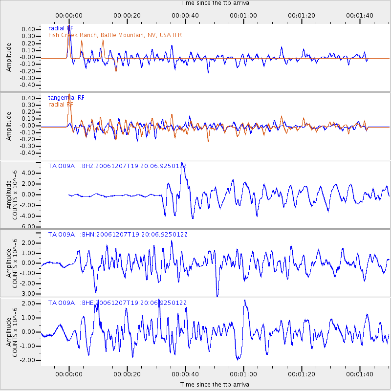
Signal To Noise
| Channel | StoN | STA | LTA |
| TA:O09A: :BHN:20061207T19:20:06.925012Z | 2.1395535 | 5.8803084E-7 | 2.7483813E-7 |
| TA:O09A: :BHE:20061207T19:20:06.925012Z | 3.0257955 | 5.759248E-7 | 1.903383E-7 |
| TA:O09A: :BHZ:20061207T19:20:06.925012Z | 11.074763 | 1.5196857E-6 | 1.3722061E-7 |
| Arrivals |
| Ps | 8.0 SECOND |
| PpPs | 29 SECOND |
| PsPs/PpSs | 37 SECOND |


