You are here: Home > Network List > TA - USArray Transportable Network (new EarthScope stations) Stations List
> Station P01C Double 8 Ranch, Willits, CA, USA > Earthquake Result Viewer
P01C Double 8 Ranch, Willits, CA, USA - Earthquake Result Viewer

| Earthquake location: |
Vanuatu Islands |
| Earthquake latitude/longitude: |
-15.4/168.6 |
| Earthquake time(UTC): |
2007/07/15 (196) 09:27:34 GMT |
| Earthquake Depth: |
8.0 km |
| Earthquake Magnitude: |
6.0 MB, 5.8 MS, 6.1 MW, 6.0 MW |
| Earthquake Catalog/Contributor: |
WHDF/NEIC |
|
| Network: |
TA USArray Transportable Network (new EarthScope stations) |
| Station: |
P01C Double 8 Ranch, Willits, CA, USA |
| Lat/Lon: |
39.47 N/123.34 W |
| Elevation: |
441 m |
|
| Distance: |
83.6 deg |
| Az: |
46.267 deg |
| Baz: |
244.219 deg |
| Ray Param: |
0.046099056 |
| Estimated Moho Depth: |
24.0 km |
| Estimated Crust Vp/Vs: |
1.84 |
| Assumed Crust Vp: |
6.472 km/s |
| Estimated Crust Vs: |
3.517 km/s |
| Estimated Crust Poisson's Ratio: |
0.29 |
|
| Radial Match: |
92.76891 % |
| Radial Bump: |
392 |
| Transverse Match: |
83.345345 % |
| Transverse Bump: |
400 |
| SOD ConfigId: |
2564 |
| Insert Time: |
2010-03-07 03:52:52.296 +0000 |
| GWidth: |
2.5 |
| Max Bumps: |
400 |
| Tol: |
0.001 |
|
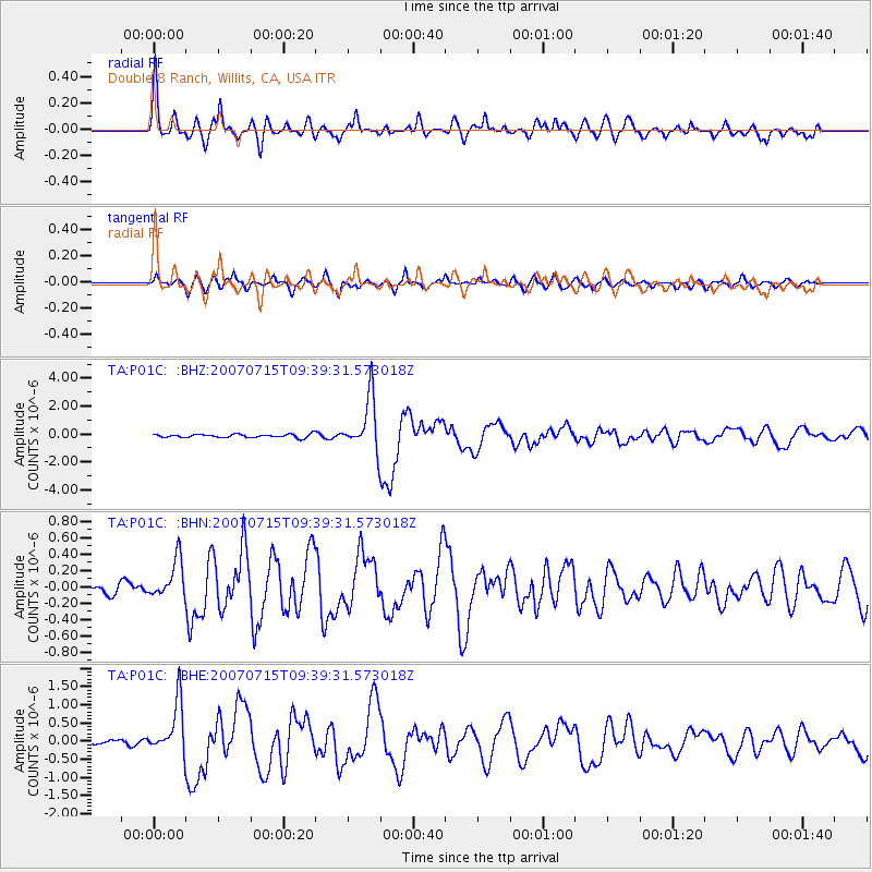
Signal To Noise
| Channel | StoN | STA | LTA |
| TA:P01C: :BHN:20070715T09:39:31.573018Z | 4.182061 | 2.3714131E-7 | 5.670441E-8 |
| TA:P01C: :BHE:20070715T09:39:31.573018Z | 9.420551 | 7.064838E-7 | 7.499389E-8 |
| TA:P01C: :BHZ:20070715T09:39:31.573018Z | 15.735402 | 1.9330766E-6 | 1.2284889E-7 |
| Arrivals |
| Ps | 3.2 SECOND |
| PpPs | 10 SECOND |
| PsPs/PpSs | 13 SECOND |


