
Station TA P01C - Double 8 Ranch, Willits, CA, USA
Network: TA - USArray Transportable Network (new EarthScope stations)
Nearby stations (2 deg radius)
| Station | Name | (Lat, Lon) | Start / End | Elevation |
| P01C | Double 8 Ranch, Willits, CA, USA | (39.47, -123.34) | 2005-08-24 / 2499-01-01 | 441 m |
| Crust2 Type: | T6,Margin /shield transition, 1 km seds. |
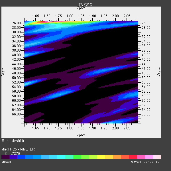
| Thickness Estimate: | 25 km |
| Thickness StdDev: | 4.6 km |
| Vp/Vs Estimate: | 1.73 |
| Vp/Vs StdDev: | 0.06 |
| Vs Estimate: | 3.746 km/s |
| Poisson's Ratio: | 0.25 |
| Peak Value: | 0.03 |
| Assumed Vp: | 6.472 km/s |
| Ps Weight: | 0.33333334 |
| PpPs Weight: | 0.33333334 |
| PsPs Weight: | 0.33333328 |
| Residual Complexity: | 0.686 |
| Nearby stations H: | +- |
| (2.0 deg) Vp/Vs: | +- |
11 with match > 90% ( 52.38095 %) and 21 with match > 80% ( 100.0 %) out of 21.
Download stack as xyz text file.
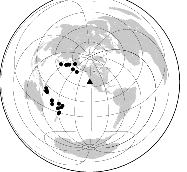
Azimuth Distribution of Events:
Prior Results for this Station
| Study | Thickness | Vp/Vs | Vp | Vs | Poissons Ratio | Extra |
| EARS | 25 km | 1.73 | 6.472 km/s | 3.746 km/s | 0.25 | |
| Crust2.0 | 32 km | 1.79 | 6.472 km/s | 3.622 km/s | 0.27 | T6,Margin /shield transition, 1 km seds. |
| Global Maxima | 25 km | 1.73 | 6.472 km/s | 3.746 km/s | 0.25 | amp=0.027527042 |
| Local Maxima 1 | 25 km | 1.89 | 6.472 km/s | 3.42 km/s | 0.31 | amp=0.014600081 |
| Local Maxima 2 | 53 km | 1.60 | 6.472 km/s | 4.039 km/s | 0.18 | amp=0.009452516 |
| Local Maxima 3 | 40 km | 1.60 | 6.472 km/s | 4.045 km/s | 0.18 | amp=0.0076053403 |
| Local Maxima 4 | 70 km | 1.97 | 6.472 km/s | 3.285 km/s | 0.33 | amp=0.0075399163 |
| Predicted Arrivals for vertical incidence (zero ray parameter) | |
| Ps | 2.81 SECOND |
| PpPs | 10.54 SECOND |
| PsPs/PpSs | 13.35 SECOND |
Events Processed for this Station
Download zip of receiver functions as SAC
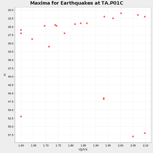
Plot maxima for each earthquake.
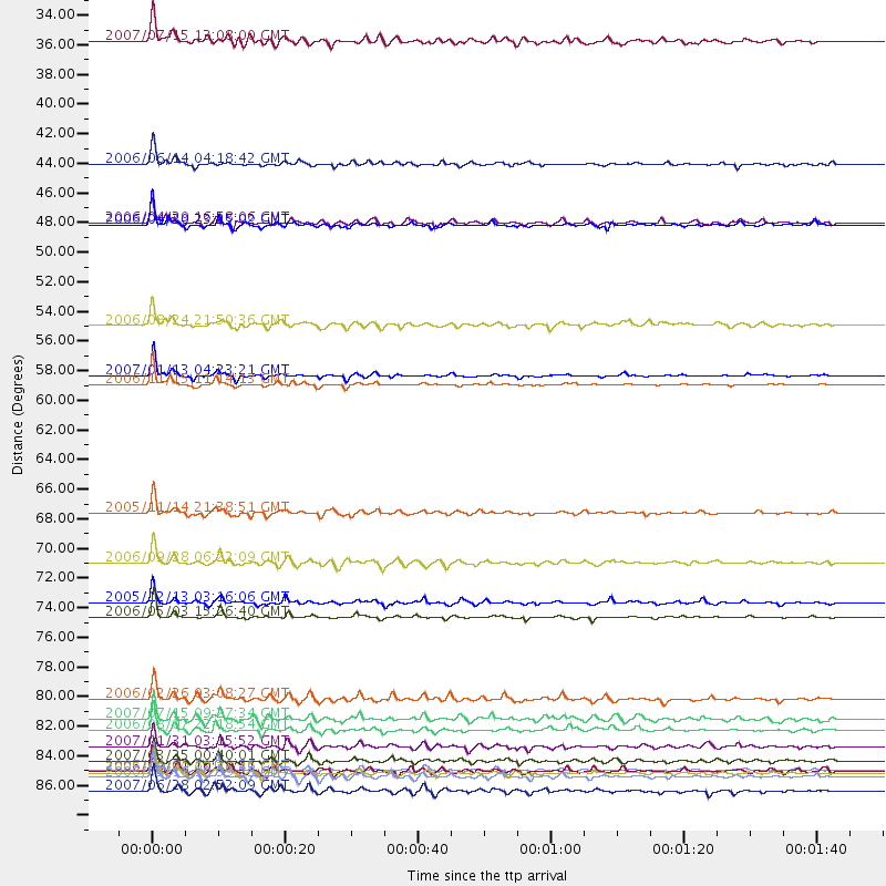
Events Used in the Stack
(21 events)| Radial Match | Distance | Baz | FERegion | Time | Lat/Lon | Depth | Magnitude |
| 98.825356 | 58.7 deg | 306.685 deg | Kuril Islands | 2006/11/15 11:14:13 GMT | (46.6, 153.3) | 10 km | 6.5 MB, 7.8 MS, 8.3 MW, 7.9 MW |
| 98.60506 | 76.0 deg | 228.604 deg | Tonga Islands | 2006/05/03 15:26:40 GMT | (-20.2, -174.1) | 55 km | 7.2 MB, 7.8 MS, 7.9 MW, 7.9 MW |
| 97.62702 | 87.4 deg | 256.925 deg | Solomon Islands | 2007/04/01 20:39:56 GMT | (-8.5, 157.0) | 10 km | 6.8 MB, 7.9 MS, 8.1 MW, 7.7 ME |
| 96.59386 | 58.0 deg | 305.874 deg | East Of Kuril Islands | 2007/01/13 04:23:21 GMT | (46.2, 154.5) | 10 km | 7.3 MB, 8.2 MS, 8.1 MW, 7.9 MW |
| 96.23935 | 87.9 deg | 224.938 deg | Kermadec Islands Region | 2006/05/16 10:39:23 GMT | (-31.8, -179.3) | 152 km | 6.8 MB, 7.4 MW, 7.4 MW |
| 95.22494 | 46.8 deg | 321.144 deg | Eastern Siberia, Russia | 2006/04/20 23:25:02 GMT | (60.9, 167.1) | 22 km | 6.8 MB, 7.6 MS, 7.6 MW, 7.3 MW |
| 94.17951 | 71.9 deg | 229.263 deg | Samoa Islands Region | 2006/09/28 06:22:09 GMT | (-16.6, -172.0) | 28 km | 6.5 MB, 6.6 MS, 6.9 MW, 6.7 MW |
| 93.911385 | 88.9 deg | 258.839 deg | Solomon Islands | 2007/06/28 02:52:09 GMT | (-8.0, 154.6) | 10 km | 6.3 MB, 6.7 MS, 6.7 MW, 6.7 MW |
| 92.76891 | 83.6 deg | 244.219 deg | Vanuatu Islands | 2007/07/15 09:27:34 GMT | (-15.4, 168.6) | 8.0 km | 6.0 MB, 5.8 MS, 6.1 MW, 6.0 MW |
| 91.56166 | 87.6 deg | 262.194 deg | New Ireland Region, P.N.G. | 2005/09/09 07:26:43 GMT | (-4.5, 153.5) | 90 km | 6.3 MB, 7.7 MW, 7.5 MW |
| 91.02958 | 68.3 deg | 301.916 deg | Off East Coast Of Honshu, Japan | 2005/11/14 21:38:51 GMT | (38.1, 144.9) | 11 km | 6.7 MB, 6.8 MS, 7.0 MW, 6.9 MW |
| 89.52781 | 33.1 deg | 308.084 deg | Fox Islands, Aleutian Islands | 2007/07/15 13:08:00 GMT | (52.5, -168.0) | 10 km | 5.8 MB, 5.9 MS, 6.1 MW, 6.0 MW |
| 89.09593 | 54.3 deg | 310.38 deg | Near East Coast Of Kamchatka | 2006/08/24 21:50:36 GMT | (51.1, 157.5) | 43 km | 5.9 MB, 6.2 MS, 6.5 MW, 6.5 MW |
| 88.75655 | 84.4 deg | 244.468 deg | Vanuatu Islands | 2006/08/07 22:18:54 GMT | (-15.8, 167.8) | 141 km | 6.0 MB, 6.8 MW, 6.8 MW |
| 88.655235 | 86.7 deg | 239.959 deg | Vanuatu Islands | 2007/03/25 00:40:01 GMT | (-20.6, 169.4) | 34 km | 6.5 MB, 7.0 MS, 7.1 MW, 7.1 MW |
| 87.73965 | 85.6 deg | 225.343 deg | Kermadec Islands, New Zealand | 2007/01/31 03:15:52 GMT | (-29.8, -178.0) | 34 km | 6.1 MB, 6.3 MS, 6.5 MW, 6.4 MW |
| 86.30222 | 42.3 deg | 307.211 deg | Rat Islands, Aleutian Islands | 2006/06/14 04:18:42 GMT | (51.8, 177.1) | 14 km | 5.9 MB, 6.4 MS, 6.4 MW, 6.4 MW |
| 83.63993 | 82.1 deg | 230.686 deg | South Of Fiji Islands | 2006/02/26 03:08:27 GMT | (-23.6, -180.0) | 535 km | 5.9 MB, 6.4 MW, 6.4 MW |
| 81.77371 | 74.9 deg | 235.204 deg | Fiji Islands Region | 2005/12/13 03:16:06 GMT | (-15.3, -178.6) | 10 km | 6.1 MB, 6.8 MS, 6.7 MW, 6.7 MW |
| 80.18236 | 87.5 deg | 259.198 deg | Solomon Islands | 2006/09/01 10:18:51 GMT | (-6.8, 155.5) | 38 km | 6.3 MB, 6.7 MS, 6.8 MW, 6.7 MW |
| 80.01496 | 46.6 deg | 320.487 deg | Eastern Siberia, Russia | 2006/04/29 16:58:06 GMT | (60.5, 167.5) | 11 km | 6.4 MB, 6.6 MS, 6.6 MW, 6.4 MW |
Losers
(0 events)| Radial Match | Distance | Baz | FERegion | Time | Lat/Lon | Depth | Magnitude | Reason |
