You are here: Home > Network List > TA - USArray Transportable Network (new EarthScope stations) Stations List
> Station P01C Double 8 Ranch, Willits, CA, USA > Earthquake Result Viewer
P01C Double 8 Ranch, Willits, CA, USA - Earthquake Result Viewer
| Earthquake location: |
Solomon Islands |
| Earthquake latitude/longitude: |
-8.0/154.6 |
| Earthquake time(UTC): |
2007/06/28 (179) 02:52:09 GMT |
| Earthquake Depth: |
10 km |
| Earthquake Magnitude: |
6.3 MB, 6.7 MS, 6.7 MW, 6.7 MW |
| Earthquake Catalog/Contributor: |
WHDF/NEIC |
|
| Network: |
TA USArray Transportable Network (new EarthScope stations) |
| Station: |
P01C Double 8 Ranch, Willits, CA, USA |
| Lat/Lon: |
39.47 N/123.34 W |
| Elevation: |
441 m |
|
| Distance: |
88.9 deg |
| Az: |
50.061 deg |
| Baz: |
258.839 deg |
| Ray Param: |
0.04223715 |
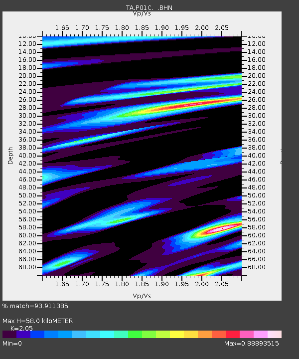
| Estimated Moho Depth: |
58.0 km |
| Estimated Crust Vp/Vs: |
2.05 |
| Assumed Crust Vp: |
6.472 km/s |
| Estimated Crust Vs: |
3.157 km/s |
| Estimated Crust Poisson's Ratio: |
0.34 |
|
| Radial Match: |
93.911385 % |
| Radial Bump: |
400 |
| Transverse Match: |
87.50224 % |
| Transverse Bump: |
400 |
| SOD ConfigId: |
2564 |
| Insert Time: |
2010-03-07 03:52:54.160 +0000 |
| GWidth: |
2.5 |
| Max Bumps: |
400 |
| Tol: |
0.001 |
|

Signal To Noise
| Channel | StoN | STA | LTA |
| TA:P01C: :BHN:20070628T03:04:32.574011Z | 1.5246007 | 1.3910629E-7 | 9.124113E-8 |
| TA:P01C: :BHE:20070628T03:04:32.574011Z | 9.463587 | 8.1349975E-7 | 8.596104E-8 |
| TA:P01C: :BHZ:20070628T03:04:32.574011Z | 15.023843 | 1.8217594E-6 | 1.2125788E-7 |
| Arrivals |
| Ps | 9.6 SECOND |
| PpPs | 27 SECOND |
| PsPs/PpSs | 36 SECOND |


