You are here: Home > Network List > TA - USArray Transportable Network (new EarthScope stations) Stations List
> Station P01C Double 8 Ranch, Willits, CA, USA > Earthquake Result Viewer
P01C Double 8 Ranch, Willits, CA, USA - Earthquake Result Viewer
| Earthquake location: |
Kuril Islands |
| Earthquake latitude/longitude: |
46.6/153.3 |
| Earthquake time(UTC): |
2006/11/15 (319) 11:14:13 GMT |
| Earthquake Depth: |
10 km |
| Earthquake Magnitude: |
6.5 MB, 7.8 MS, 8.3 MW, 7.9 MW |
| Earthquake Catalog/Contributor: |
WHDF/NEIC |
|
| Network: |
TA USArray Transportable Network (new EarthScope stations) |
| Station: |
P01C Double 8 Ranch, Willits, CA, USA |
| Lat/Lon: |
39.47 N/123.34 W |
| Elevation: |
441 m |
|
| Distance: |
58.7 deg |
| Az: |
64.174 deg |
| Baz: |
306.685 deg |
| Ray Param: |
0.062688954 |
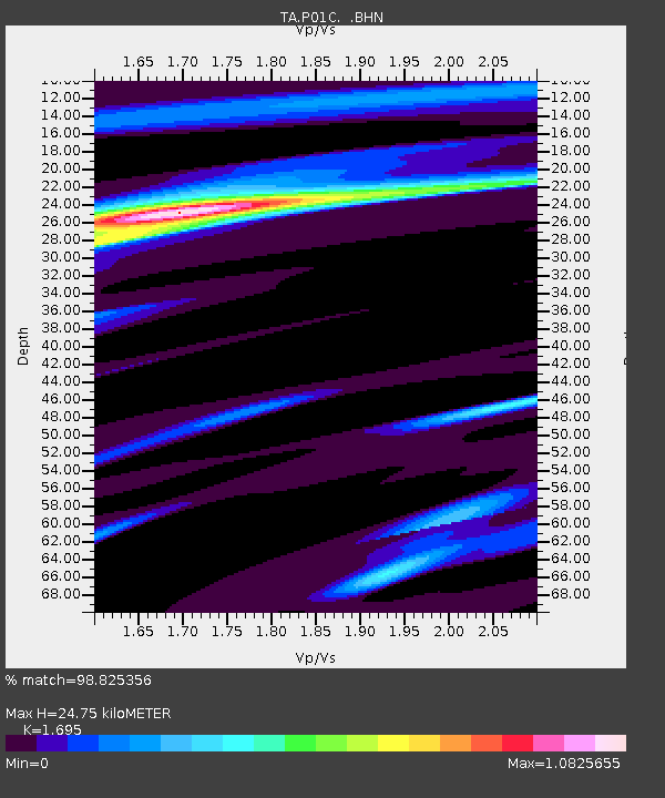
| Estimated Moho Depth: |
24.75 km |
| Estimated Crust Vp/Vs: |
1.70 |
| Assumed Crust Vp: |
6.472 km/s |
| Estimated Crust Vs: |
3.818 km/s |
| Estimated Crust Poisson's Ratio: |
0.23 |
|
| Radial Match: |
98.825356 % |
| Radial Bump: |
205 |
| Transverse Match: |
94.61525 % |
| Transverse Bump: |
400 |
| SOD ConfigId: |
2564 |
| Insert Time: |
2010-03-07 03:53:04.191 +0000 |
| GWidth: |
2.5 |
| Max Bumps: |
400 |
| Tol: |
0.001 |
|

Signal To Noise
| Channel | StoN | STA | LTA |
| TA:P01C: :BHN:20061115T11:23:39.975029Z | 1.7107605 | 5.772286E-7 | 3.3741054E-7 |
| TA:P01C: :BHE:20061115T11:23:39.975029Z | 0.4983828 | 3.0049793E-7 | 6.02946E-7 |
| TA:P01C: :BHZ:20061115T11:23:39.975029Z | 2.665481 | 1.2408221E-6 | 4.6551526E-7 |
| Arrivals |
| Ps | 2.8 SECOND |
| PpPs | 9.8 SECOND |
| PsPs/PpSs | 13 SECOND |


