You are here: Home > Network List > TA - USArray Transportable Network (new EarthScope stations) Stations List
> Station P01C Double 8 Ranch, Willits, CA, USA > Earthquake Result Viewer
P01C Double 8 Ranch, Willits, CA, USA - Earthquake Result Viewer
| Earthquake location: |
Kermadec Islands Region |
| Earthquake latitude/longitude: |
-31.8/-179.3 |
| Earthquake time(UTC): |
2006/05/16 (136) 10:39:23 GMT |
| Earthquake Depth: |
152 km |
| Earthquake Magnitude: |
6.8 MB, 7.4 MW, 7.4 MW |
| Earthquake Catalog/Contributor: |
WHDF/NEIC |
|
| Network: |
TA USArray Transportable Network (new EarthScope stations) |
| Station: |
P01C Double 8 Ranch, Willits, CA, USA |
| Lat/Lon: |
39.47 N/123.34 W |
| Elevation: |
441 m |
|
| Distance: |
87.9 deg |
| Az: |
39.94 deg |
| Baz: |
224.938 deg |
| Ray Param: |
0.042663593 |
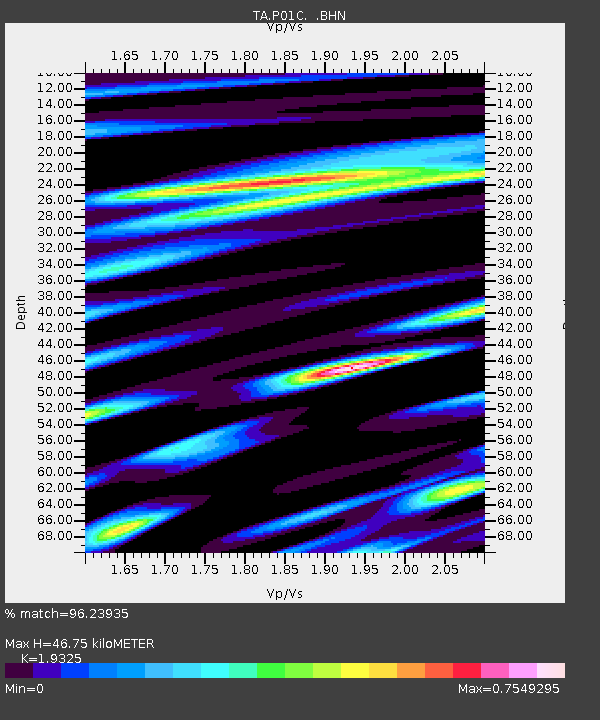
| Estimated Moho Depth: |
46.75 km |
| Estimated Crust Vp/Vs: |
1.93 |
| Assumed Crust Vp: |
6.472 km/s |
| Estimated Crust Vs: |
3.349 km/s |
| Estimated Crust Poisson's Ratio: |
0.32 |
|
| Radial Match: |
96.23935 % |
| Radial Bump: |
400 |
| Transverse Match: |
86.74718 % |
| Transverse Bump: |
400 |
| SOD ConfigId: |
2669 |
| Insert Time: |
2010-03-07 03:53:13.400 +0000 |
| GWidth: |
2.5 |
| Max Bumps: |
400 |
| Tol: |
0.001 |
|

Signal To Noise
| Channel | StoN | STA | LTA |
| TA:P01C: :BHN:20060516T10:51:24.47501Z | 0.6419717 | 2.2417244E-7 | 3.4919364E-7 |
| TA:P01C: :BHE:20060516T10:51:24.47501Z | 1.7820137 | 6.1322567E-7 | 3.441195E-7 |
| TA:P01C: :BHZ:20060516T10:51:24.47501Z | 4.5053434 | 1.2773924E-6 | 2.835283E-7 |
| Arrivals |
| Ps | 6.9 SECOND |
| PpPs | 21 SECOND |
| PsPs/PpSs | 28 SECOND |


