You are here: Home > Network List > TA - USArray Transportable Network (new EarthScope stations) Stations List
> Station P01C Double 8 Ranch, Willits, CA, USA > Earthquake Result Viewer
P01C Double 8 Ranch, Willits, CA, USA - Earthquake Result Viewer
| Earthquake location: |
Near East Coast Of Kamchatka |
| Earthquake latitude/longitude: |
51.1/157.5 |
| Earthquake time(UTC): |
2006/08/24 (236) 21:50:36 GMT |
| Earthquake Depth: |
43 km |
| Earthquake Magnitude: |
5.9 MB, 6.2 MS, 6.5 MW, 6.5 MW |
| Earthquake Catalog/Contributor: |
WHDF/NEIC |
|
| Network: |
TA USArray Transportable Network (new EarthScope stations) |
| Station: |
P01C Double 8 Ranch, Willits, CA, USA |
| Lat/Lon: |
39.47 N/123.34 W |
| Elevation: |
441 m |
|
| Distance: |
54.3 deg |
| Az: |
69.415 deg |
| Baz: |
310.38 deg |
| Ray Param: |
0.065445304 |
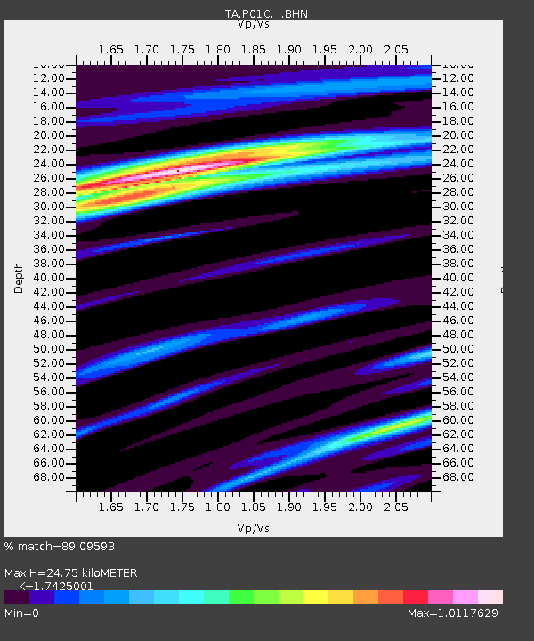
| Estimated Moho Depth: |
24.75 km |
| Estimated Crust Vp/Vs: |
1.74 |
| Assumed Crust Vp: |
6.472 km/s |
| Estimated Crust Vs: |
3.714 km/s |
| Estimated Crust Poisson's Ratio: |
0.25 |
|
| Radial Match: |
89.09593 % |
| Radial Bump: |
400 |
| Transverse Match: |
66.46511 % |
| Transverse Bump: |
400 |
| SOD ConfigId: |
2665 |
| Insert Time: |
2010-03-07 03:53:23.043 +0000 |
| GWidth: |
2.5 |
| Max Bumps: |
400 |
| Tol: |
0.001 |
|

Signal To Noise
| Channel | StoN | STA | LTA |
| TA:P01C: :BHN:20060824T21:59:27.949011Z | 1.8608513 | 5.1448495E-7 | 2.7647826E-7 |
| TA:P01C: :BHE:20060824T21:59:27.949011Z | 3.8575666 | 1.1324314E-6 | 2.9356107E-7 |
| TA:P01C: :BHZ:20060824T21:59:27.949011Z | 7.593924 | 2.6641233E-6 | 3.50823E-7 |
| Arrivals |
| Ps | 3.0 SECOND |
| PpPs | 9.9 SECOND |
| PsPs/PpSs | 13 SECOND |


