You are here: Home > Network List > TA - USArray Transportable Network (new EarthScope stations) Stations List
> Station S11A Rachel, NV, USA > Earthquake Result Viewer
S11A Rachel, NV, USA - Earthquake Result Viewer
| Earthquake location: |
Svalbard Region |
| Earthquake latitude/longitude: |
77.1/18.6 |
| Earthquake time(UTC): |
2008/02/21 (052) 02:46:17 GMT |
| Earthquake Depth: |
10 km |
| Earthquake Magnitude: |
5.7 MB, 5.9 MS, 6.1 MW, 6.0 MW |
| Earthquake Catalog/Contributor: |
WHDF/NEIC |
|
| Network: |
TA USArray Transportable Network (new EarthScope stations) |
| Station: |
S11A Rachel, NV, USA |
| Lat/Lon: |
37.64 N/115.75 W |
| Elevation: |
1456 m |
|
| Distance: |
62.1 deg |
| Az: |
320.017 deg |
| Baz: |
10.495 deg |
| Ray Param: |
0.060444124 |
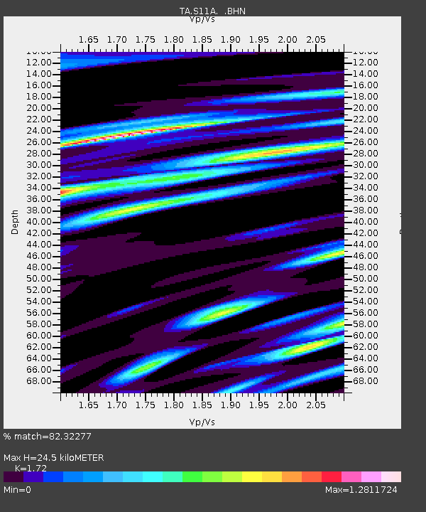
| Estimated Moho Depth: |
24.5 km |
| Estimated Crust Vp/Vs: |
1.72 |
| Assumed Crust Vp: |
6.276 km/s |
| Estimated Crust Vs: |
3.649 km/s |
| Estimated Crust Poisson's Ratio: |
0.24 |
|
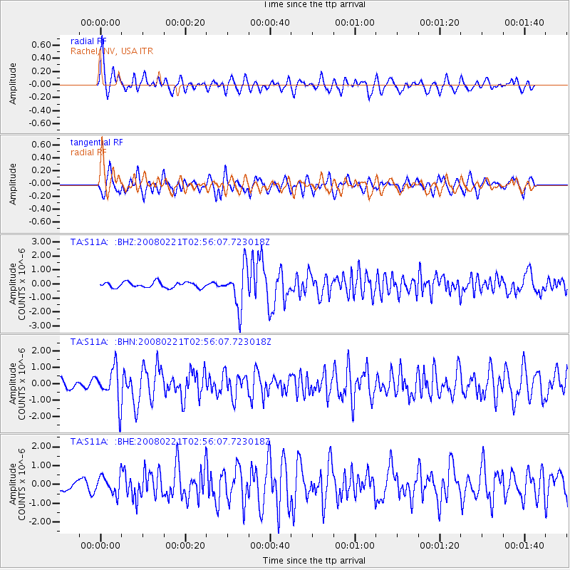
| Radial Match: |
82.32277 % |
| Radial Bump: |
400 |
| Transverse Match: |
65.32121 % |
| Transverse Bump: |
400 |
| SOD ConfigId: |
2564 |
| Insert Time: |
2010-03-07 03:53:28.633 +0000 |
| GWidth: |
2.5 |
| Max Bumps: |
400 |
| Tol: |
0.001 |
|
Signal To Noise
| Channel | StoN | STA | LTA |
| TA:S11A: :BHN:20080221T02:56:07.723018Z | 4.625586 | 1.1099677E-6 | 2.3996262E-7 |
| TA:S11A: :BHE:20080221T02:56:07.723018Z | 2.2238233 | 4.9078767E-7 | 2.2069545E-7 |
| TA:S11A: :BHZ:20080221T02:56:07.723018Z | 7.4306893 | 1.4703792E-6 | 1.9787923E-7 |
| Arrivals |
| Ps | 2.9 SECOND |
| PpPs | 10 SECOND |
| PsPs/PpSs | 13 SECOND |


