
Station TA S11A - Rachel, NV, USA
Network: TA - USArray Transportable Network (new EarthScope stations)
Nearby stations (2 deg radius)
| Station | Name | (Lat, Lon) | Start / End | Elevation |
| S11A | Rachel, NV, USA | (37.64, -115.75) | 2007-01-23 / 2499-01-01 | 1.5 km |
| Crust2 Type: | M5,extended crust, 0.5 km seds. |
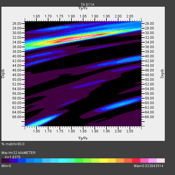
| Thickness Estimate: | 32 km |
| Thickness StdDev: | 9.3 km |
| Vp/Vs Estimate: | 1.84 |
| Vp/Vs StdDev: | 0.09 |
| Vs Estimate: | 3.415 km/s |
| Poisson's Ratio: | 0.29 |
| Peak Value: | 0.03 |
| Assumed Vp: | 6.276 km/s |
| Ps Weight: | 0.33333334 |
| PpPs Weight: | 0.33333334 |
| PsPs Weight: | 0.33333328 |
| Residual Complexity: | 0.502 |
| Nearby stations H: | +- |
| (2.0 deg) Vp/Vs: | +- |
2 with match > 90% ( 14.285714 %) and 14 with match > 80% ( 100.0 %) out of 14.
Download stack as xyz text file.
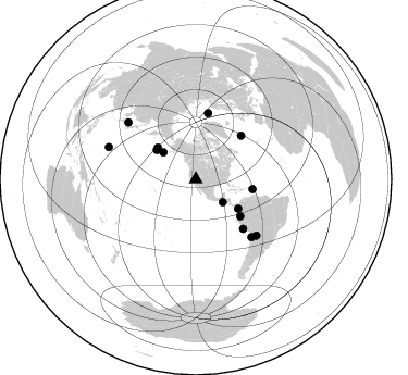
Azimuth Distribution of Events:
Prior Results for this Station
| Study | Thickness | Vp/Vs | Vp | Vs | Poissons Ratio | Extra |
| EARS | 32 km | 1.84 | 6.276 km/s | 3.415 km/s | 0.29 | |
| Crust2.0 | 31 km | 1.78 | 6.276 km/s | 3.529 km/s | 0.27 | M5,extended crust, 0.5 km seds. |
| Global Maxima | 32 km | 1.84 | 6.276 km/s | 3.415 km/s | 0.29 | amp=0.033843514 |
| Local Maxima 1 | 69 km | 1.65 | 6.276 km/s | 3.792 km/s | 0.21 | amp=0.01535604 |
| Local Maxima 2 | 35 km | 1.66 | 6.276 km/s | 3.781 km/s | 0.22 | amp=0.015099883 |
| Local Maxima 3 | 32 km | 1.80 | 6.276 km/s | 3.496 km/s | 0.27 | amp=0.011363126 |
| Local Maxima 4 | 29 km | 2.02 | 6.276 km/s | 3.115 km/s | 0.34 | amp=0.008160922 |
| Predicted Arrivals for vertical incidence (zero ray parameter) | |
| Ps | 4.27 SECOND |
| PpPs | 14.47 SECOND |
| PsPs/PpSs | 18.74 SECOND |
Events Processed for this Station
Download zip of receiver functions as SAC
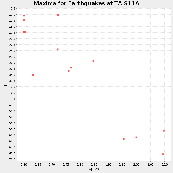
Plot maxima for each earthquake.
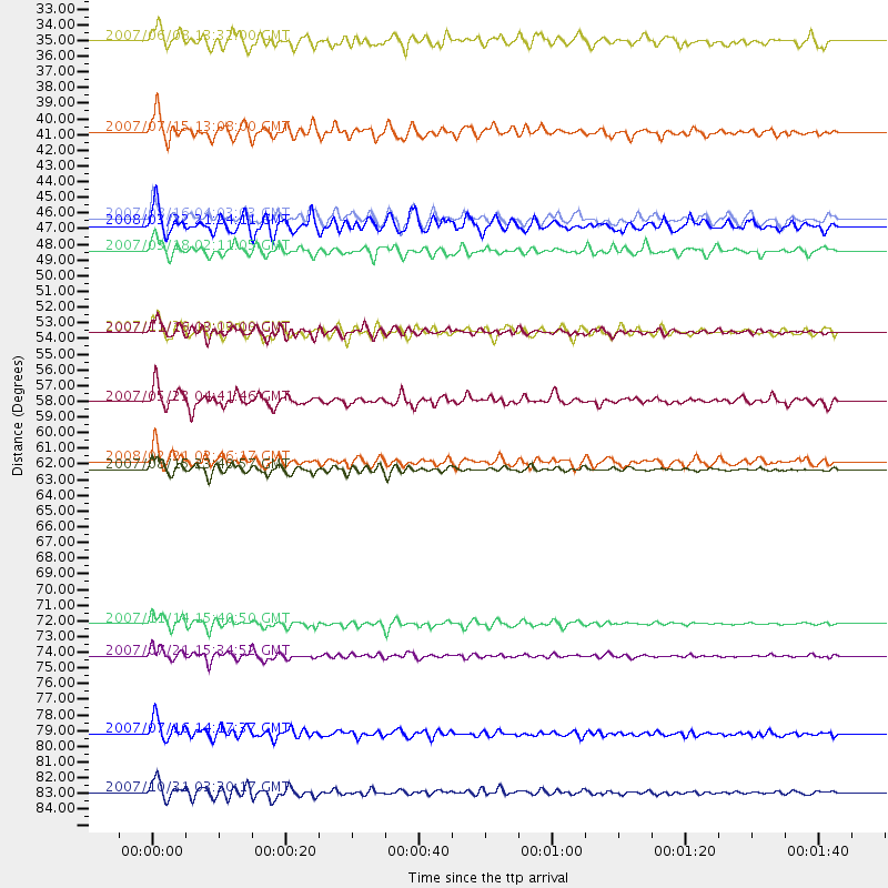
Events Used in the Stack
(14 events)| Radial Match | Distance | Baz | FERegion | Time | Lat/Lon | Depth | Magnitude |
| 91.532715 | 62.7 deg | 136.245 deg | Near Coast Of Peru | 2007/08/15 23:40:57 GMT | (-13.4, -76.6) | 39 km | 6.7 MB, 7.9 MS, 8.0 MW, 7.5 ME |
| 90.84414 | 73.5 deg | 136.115 deg | Northern Chile | 2007/11/14 15:40:50 GMT | (-22.2, -69.9) | 40 km | 6.7 MB, 7.4 MS, 7.7 MW, 7.4 ME |
| 88.618904 | 45.5 deg | 309.688 deg | Andreanof Islands, Aleutian Is. | 2008/03/22 21:24:11 GMT | (52.2, -178.7) | 132 km | 5.8 MB, 6.2 MW, 6.1 MW |
| 86.4107 | 53.0 deg | 99.926 deg | Windward Islands | 2007/11/29 19:00:19 GMT | (15.0, -61.3) | 148 km | 6.9 MB, 7.4 MW, 7.4 MW |
| 86.383446 | 47.3 deg | 124.817 deg | South Of Panama | 2007/03/18 02:11:05 GMT | (4.6, -78.5) | 8.0 km | 6.4 MB, 5.7 MS, 6.2 MW, 6.1 MW |
| 86.076546 | 32.5 deg | 130.217 deg | Near Coast Of Guatemala | 2007/06/08 13:32:00 GMT | (13.8, -90.8) | 48 km | 5.5 MB, 5.4 MS, 5.8 MW, 5.8 MW |
| 85.500114 | 75.8 deg | 132.925 deg | Jujuy Province, Argentina | 2007/07/21 15:34:52 GMT | (-22.2, -65.8) | 290 km | 5.8 MB, 6.4 MW, 6.3 MW |
| 84.08441 | 53.0 deg | 129.788 deg | Peru-Ecuador Border Region | 2007/11/16 03:13:00 GMT | (-2.3, -77.8) | 123 km | 6.3 MB, 6.8 MW, 6.7 MW |
| 82.60107 | 57.9 deg | 46.074 deg | Northern Mid-Atlantic Ridge | 2007/05/23 04:41:46 GMT | (52.4, -31.8) | 10 km | 5.6 MS, 5.4 MB, 5.7 MW, 5.6 MW |
| 82.32277 | 62.1 deg | 10.495 deg | Svalbard Region | 2008/02/21 02:46:17 GMT | (77.1, 18.6) | 10 km | 5.7 MB, 5.9 MS, 6.1 MW, 6.0 MW |
| 81.27899 | 38.9 deg | 309.613 deg | Fox Islands, Aleutian Islands | 2007/07/15 13:08:00 GMT | (52.5, -168.0) | 10 km | 5.8 MB, 5.9 MS, 6.1 MW, 6.0 MW |
| 80.91076 | 85.4 deg | 290.219 deg | Mariana Islands | 2007/10/31 03:30:17 GMT | (18.9, 145.4) | 223 km | 6.2 MB, 7.2 MW, 7.2 MW |
| 80.39136 | 45.0 deg | 306.849 deg | Andreanof Islands, Aleutian Is. | 2007/08/16 04:03:03 GMT | (50.2, -177.6) | 15 km | 5.8 MB |
| 80.06238 | 81.3 deg | 310.022 deg | Sea Of Japan | 2007/07/16 14:17:37 GMT | (36.8, 134.9) | 350 km | 6.2 MB, 6.8 MW, 6.8 MW |
Losers
(0 events)| Radial Match | Distance | Baz | FERegion | Time | Lat/Lon | Depth | Magnitude | Reason |
