You are here: Home > Network List > TA - USArray Transportable Network (new EarthScope stations) Stations List
> Station S11A Rachel, NV, USA > Earthquake Result Viewer
S11A Rachel, NV, USA - Earthquake Result Viewer
| Earthquake location: |
Windward Islands |
| Earthquake latitude/longitude: |
15.0/-61.3 |
| Earthquake time(UTC): |
2007/11/29 (333) 19:00:19 GMT |
| Earthquake Depth: |
148 km |
| Earthquake Magnitude: |
6.9 MB, 7.4 MW, 7.4 MW |
| Earthquake Catalog/Contributor: |
WHDF/NEIC |
|
| Network: |
TA USArray Transportable Network (new EarthScope stations) |
| Station: |
S11A Rachel, NV, USA |
| Lat/Lon: |
37.64 N/115.75 W |
| Elevation: |
1456 m |
|
| Distance: |
53.0 deg |
| Az: |
305.998 deg |
| Baz: |
99.926 deg |
| Ray Param: |
0.06588617 |
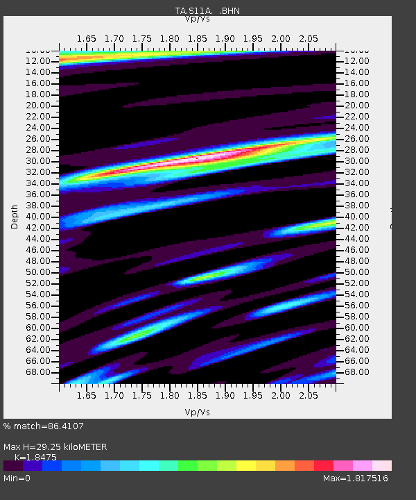
| Estimated Moho Depth: |
29.25 km |
| Estimated Crust Vp/Vs: |
1.85 |
| Assumed Crust Vp: |
6.276 km/s |
| Estimated Crust Vs: |
3.397 km/s |
| Estimated Crust Poisson's Ratio: |
0.29 |
|
| Radial Match: |
86.4107 % |
| Radial Bump: |
400 |
| Transverse Match: |
81.78663 % |
| Transverse Bump: |
400 |
| SOD ConfigId: |
2564 |
| Insert Time: |
2010-03-07 03:53:30.019 +0000 |
| GWidth: |
2.5 |
| Max Bumps: |
400 |
| Tol: |
0.001 |
|
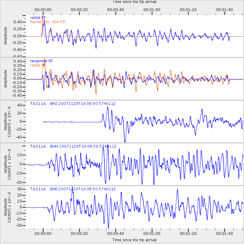
Signal To Noise
| Channel | StoN | STA | LTA |
| TA:S11A: :BHN:20071129T19:08:50.574011Z | 5.1601872 | 2.105164E-6 | 4.0796272E-7 |
| TA:S11A: :BHE:20071129T19:08:50.574011Z | 15.544 | 2.6528305E-6 | 1.706659E-7 |
| TA:S11A: :BHZ:20071129T19:08:50.574011Z | 24.830063 | 6.9165358E-6 | 2.7855492E-7 |
| Arrivals |
| Ps | 4.1 SECOND |
| PpPs | 13 SECOND |
| PsPs/PpSs | 17 SECOND |


