You are here: Home > Network List > TA - USArray Transportable Network (new EarthScope stations) Stations List
> Station S11A Rachel, NV, USA > Earthquake Result Viewer
S11A Rachel, NV, USA - Earthquake Result Viewer
| Earthquake location: |
Near Coast Of Peru |
| Earthquake latitude/longitude: |
-13.4/-76.6 |
| Earthquake time(UTC): |
2007/08/15 (227) 23:40:57 GMT |
| Earthquake Depth: |
39 km |
| Earthquake Magnitude: |
6.7 MB, 7.9 MS, 8.0 MW, 7.5 ME |
| Earthquake Catalog/Contributor: |
WHDF/NEIC |
|
| Network: |
TA USArray Transportable Network (new EarthScope stations) |
| Station: |
S11A Rachel, NV, USA |
| Lat/Lon: |
37.64 N/115.75 W |
| Elevation: |
1456 m |
|
| Distance: |
62.7 deg |
| Az: |
325.66 deg |
| Baz: |
136.245 deg |
| Ray Param: |
0.060006417 |
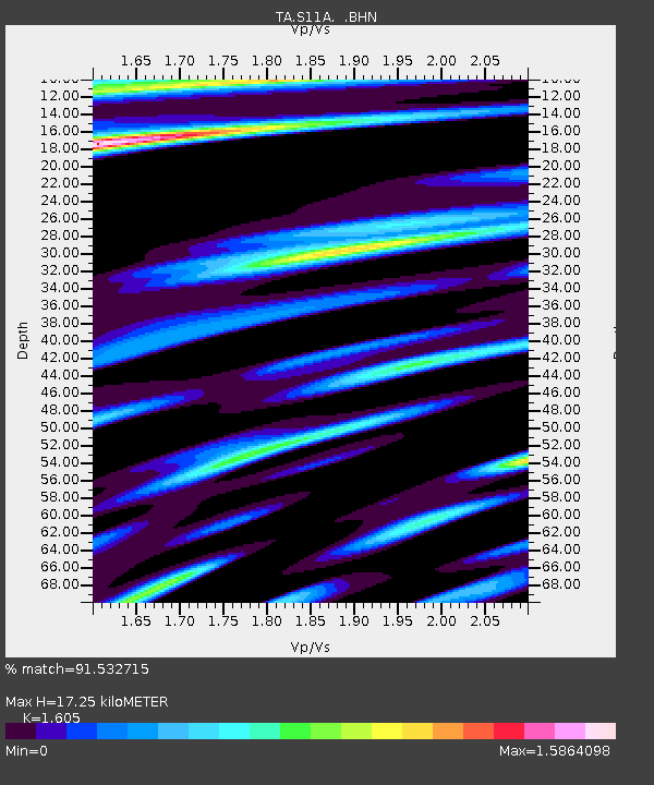
| Estimated Moho Depth: |
17.25 km |
| Estimated Crust Vp/Vs: |
1.61 |
| Assumed Crust Vp: |
6.276 km/s |
| Estimated Crust Vs: |
3.91 km/s |
| Estimated Crust Poisson's Ratio: |
0.18 |
|
| Radial Match: |
91.532715 % |
| Radial Bump: |
400 |
| Transverse Match: |
84.625206 % |
| Transverse Bump: |
400 |
| SOD ConfigId: |
2564 |
| Insert Time: |
2010-03-07 03:53:40.185 +0000 |
| GWidth: |
2.5 |
| Max Bumps: |
400 |
| Tol: |
0.001 |
|
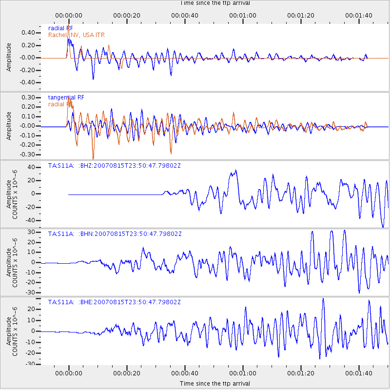
Signal To Noise
| Channel | StoN | STA | LTA |
| TA:S11A: :BHN:20070815T23:50:47.79802Z | 8.488581 | 1.0512033E-6 | 1.2383734E-7 |
| TA:S11A: :BHE:20070815T23:50:47.79802Z | 6.2949233 | 7.4982614E-7 | 1.1911602E-7 |
| TA:S11A: :BHZ:20070815T23:50:47.79802Z | 19.901962 | 2.4306994E-6 | 1.2213366E-7 |
| Arrivals |
| Ps | 1.7 SECOND |
| PpPs | 6.8 SECOND |
| PsPs/PpSs | 8.6 SECOND |


