You are here: Home > Network List > TA - USArray Transportable Network (new EarthScope stations) Stations List
> Station S11A Rachel, NV, USA > Earthquake Result Viewer
S11A Rachel, NV, USA - Earthquake Result Viewer
| Earthquake location: |
Sea Of Japan |
| Earthquake latitude/longitude: |
36.8/134.9 |
| Earthquake time(UTC): |
2007/07/16 (197) 14:17:37 GMT |
| Earthquake Depth: |
350 km |
| Earthquake Magnitude: |
6.2 MB, 6.8 MW, 6.8 MW |
| Earthquake Catalog/Contributor: |
WHDF/NEIC |
|
| Network: |
TA USArray Transportable Network (new EarthScope stations) |
| Station: |
S11A Rachel, NV, USA |
| Lat/Lon: |
37.64 N/115.75 W |
| Elevation: |
1456 m |
|
| Distance: |
81.3 deg |
| Az: |
49.237 deg |
| Baz: |
310.022 deg |
| Ray Param: |
0.046736367 |
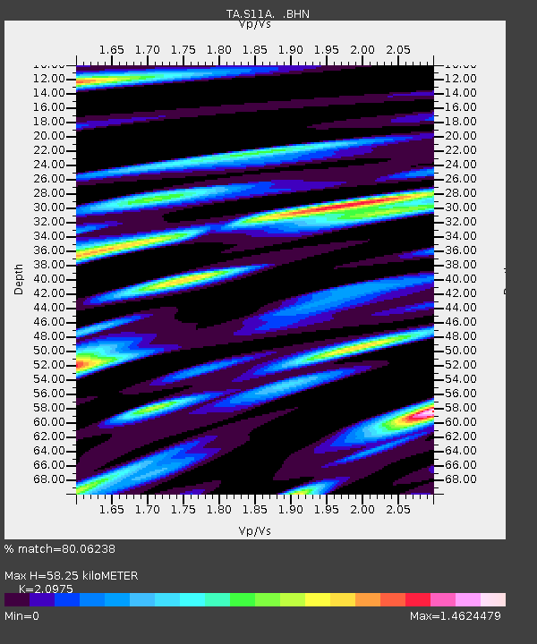
| Estimated Moho Depth: |
58.25 km |
| Estimated Crust Vp/Vs: |
2.10 |
| Assumed Crust Vp: |
6.276 km/s |
| Estimated Crust Vs: |
2.992 km/s |
| Estimated Crust Poisson's Ratio: |
0.35 |
|
| Radial Match: |
80.06238 % |
| Radial Bump: |
400 |
| Transverse Match: |
74.30527 % |
| Transverse Bump: |
400 |
| SOD ConfigId: |
2564 |
| Insert Time: |
2010-03-07 03:53:43.792 +0000 |
| GWidth: |
2.5 |
| Max Bumps: |
400 |
| Tol: |
0.001 |
|
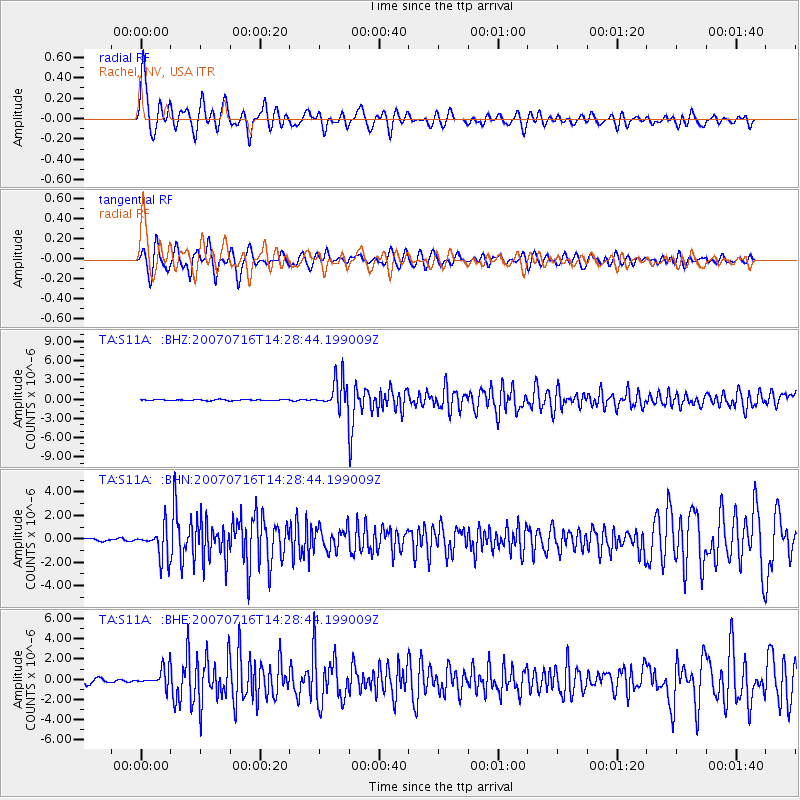
Signal To Noise
| Channel | StoN | STA | LTA |
| TA:S11A: :BHN:20070716T14:28:44.199009Z | 10.229806 | 1.3009894E-6 | 1.2717635E-7 |
| TA:S11A: :BHE:20070716T14:28:44.199009Z | 5.1684794 | 8.7935683E-7 | 1.701384E-7 |
| TA:S11A: :BHZ:20070716T14:28:44.199009Z | 26.24704 | 2.2084457E-6 | 8.414076E-8 |
| Arrivals |
| Ps | 10 SECOND |
| PpPs | 28 SECOND |
| PsPs/PpSs | 39 SECOND |


