You are here: Home > Network List > TA - USArray Transportable Network (new EarthScope stations) Stations List
> Station S11A Rachel, NV, USA > Earthquake Result Viewer
S11A Rachel, NV, USA - Earthquake Result Viewer
| Earthquake location: |
Near Coast Of Guatemala |
| Earthquake latitude/longitude: |
13.8/-90.8 |
| Earthquake time(UTC): |
2007/06/08 (159) 13:32:00 GMT |
| Earthquake Depth: |
48 km |
| Earthquake Magnitude: |
5.5 MB, 5.4 MS, 5.8 MW, 5.8 MW |
| Earthquake Catalog/Contributor: |
WHDF/NEIC |
|
| Network: |
TA USArray Transportable Network (new EarthScope stations) |
| Station: |
S11A Rachel, NV, USA |
| Lat/Lon: |
37.64 N/115.75 W |
| Elevation: |
1456 m |
|
| Distance: |
32.5 deg |
| Az: |
321.39 deg |
| Baz: |
130.217 deg |
| Ray Param: |
0.0785329 |
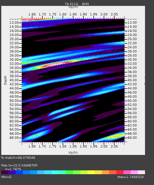
| Estimated Moho Depth: |
32.0 km |
| Estimated Crust Vp/Vs: |
1.77 |
| Assumed Crust Vp: |
6.276 km/s |
| Estimated Crust Vs: |
3.551 km/s |
| Estimated Crust Poisson's Ratio: |
0.26 |
|
| Radial Match: |
86.076546 % |
| Radial Bump: |
400 |
| Transverse Match: |
84.77813 % |
| Transverse Bump: |
400 |
| SOD ConfigId: |
2564 |
| Insert Time: |
2010-03-07 03:53:47.051 +0000 |
| GWidth: |
2.5 |
| Max Bumps: |
400 |
| Tol: |
0.001 |
|
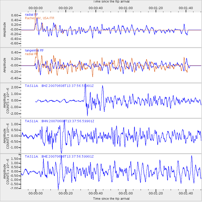
Signal To Noise
| Channel | StoN | STA | LTA |
| TA:S11A: :BHN:20070608T13:37:56.59901Z | 1.854138 | 2.7678843E-7 | 1.4928146E-7 |
| TA:S11A: :BHE:20070608T13:37:56.59901Z | 1.2078713 | 2.2352216E-7 | 1.8505462E-7 |
| TA:S11A: :BHZ:20070608T13:37:56.59901Z | 9.005377 | 1.0155549E-6 | 1.12772064E-7 |
| Arrivals |
| Ps | 4.2 SECOND |
| PpPs | 13 SECOND |
| PsPs/PpSs | 17 SECOND |


