You are here: Home > Network List > TA - USArray Transportable Network (new EarthScope stations) Stations List
> Station I11A Placerville, ID, USA > Earthquake Result Viewer
I11A Placerville, ID, USA - Earthquake Result Viewer
| Earthquake location: |
Guatemala |
| Earthquake latitude/longitude: |
14.1/-91.5 |
| Earthquake time(UTC): |
2008/01/05 (005) 01:56:45 GMT |
| Earthquake Depth: |
66 km |
| Earthquake Magnitude: |
5.6 MW, 5.4 MB, 5.6 MW |
| Earthquake Catalog/Contributor: |
WHDF/NEIC |
|
| Network: |
TA USArray Transportable Network (new EarthScope stations) |
| Station: |
I11A Placerville, ID, USA |
| Lat/Lon: |
43.91 N/115.96 W |
| Elevation: |
1288 m |
|
| Distance: |
36.3 deg |
| Az: |
329.625 deg |
| Baz: |
137.253 deg |
| Ray Param: |
0.07655838 |
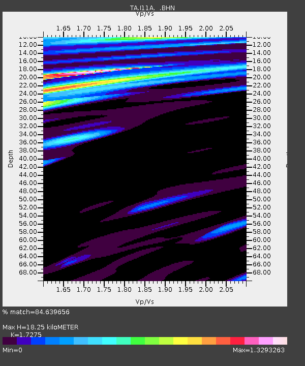
| Estimated Moho Depth: |
18.25 km |
| Estimated Crust Vp/Vs: |
1.73 |
| Assumed Crust Vp: |
6.291 km/s |
| Estimated Crust Vs: |
3.642 km/s |
| Estimated Crust Poisson's Ratio: |
0.25 |
|
| Radial Match: |
84.639656 % |
| Radial Bump: |
400 |
| Transverse Match: |
85.895226 % |
| Transverse Bump: |
400 |
| SOD ConfigId: |
2564 |
| Insert Time: |
2010-03-07 03:58:05.971 +0000 |
| GWidth: |
2.5 |
| Max Bumps: |
400 |
| Tol: |
0.001 |
|
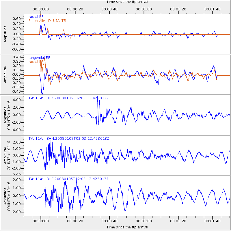
Signal To Noise
| Channel | StoN | STA | LTA |
| TA:I11A: :BHN:20080105T02:03:12.423013Z | 2.8920178 | 1.106024E-6 | 3.8244022E-7 |
| TA:I11A: :BHE:20080105T02:03:12.423013Z | 1.1735201 | 5.28872E-7 | 4.5067148E-7 |
| TA:I11A: :BHZ:20080105T02:03:12.423013Z | 2.7437851 | 1.7253186E-6 | 6.288097E-7 |
| Arrivals |
| Ps | 2.3 SECOND |
| PpPs | 7.4 SECOND |
| PsPs/PpSs | 9.6 SECOND |


