
Station TA I11A - Placerville, ID, USA
Network: TA - USArray Transportable Network (new EarthScope stations)
Nearby stations (2 deg radius)
| Station | Name | (Lat, Lon) | Start / End | Elevation |
| I11A | Placerville, ID, USA | (43.91, -115.96) | 2006-11-16 / 2499-01-01 | 1.3 km |
| Crust2 Type: | M9,thick extended crust, 0.5 km seds. |
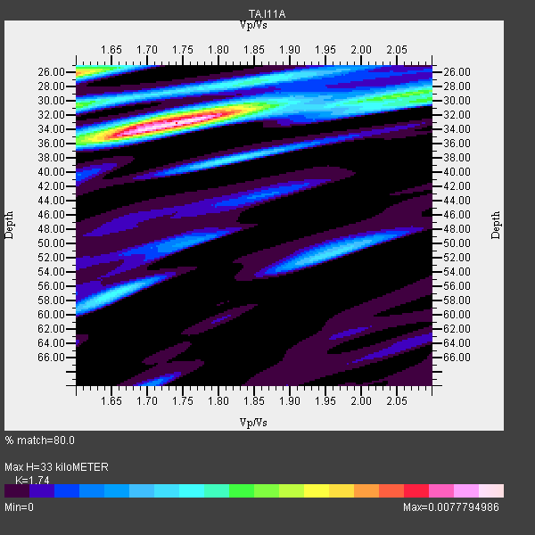
| Thickness Estimate: | 33 km |
| Thickness StdDev: | 3.2 km |
| Vp/Vs Estimate: | 1.74 |
| Vp/Vs StdDev: | 0.09 |
| Vs Estimate: | 3.616 km/s |
| Poisson's Ratio: | 0.25 |
| Peak Value: | 0.01 |
| Assumed Vp: | 6.291 km/s |
| Ps Weight: | 0.33333334 |
| PpPs Weight: | 0.33333334 |
| PsPs Weight: | 0.33333328 |
| Residual Complexity: | 0.579 |
| Nearby stations H: | +- |
| (2.0 deg) Vp/Vs: | +- |
16 with match > 90% ( 42.105263 %) and 38 with match > 80% ( 100.0 %) out of 38.
Download stack as xyz text file.
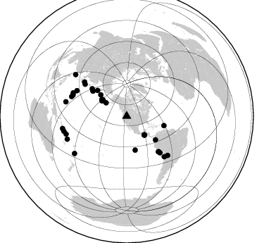
Azimuth Distribution of Events:
Prior Results for this Station
| Study | Thickness | Vp/Vs | Vp | Vs | Poissons Ratio | Extra |
| EARS | 33 km | 1.74 | 6.291 km/s | 3.616 km/s | 0.25 | |
| Crust2.0 | 40 km | 1.78 | 6.291 km/s | 3.539 km/s | 0.27 | M9,thick extended crust, 0.5 km seds. |
| Global Maxima | 33 km | 1.74 | 6.291 km/s | 3.616 km/s | 0.25 | amp=0.0077794986 |
| Local Maxima 1 | 26 km | 1.60 | 6.291 km/s | 3.932 km/s | 0.18 | amp=0.005796461 |
| Local Maxima 2 | 30 km | 1.60 | 6.291 km/s | 3.932 km/s | 0.18 | amp=0.0041098604 |
| Local Maxima 3 | 29 km | 2.08 | 6.291 km/s | 3.028 km/s | 0.35 | amp=0.0035303805 |
| Local Maxima 4 | 57 km | 1.65 | 6.291 km/s | 3.801 km/s | 0.21 | amp=0.0030784449 |
| Predicted Arrivals for vertical incidence (zero ray parameter) | |
| Ps | 3.88 SECOND |
| PpPs | 14.37 SECOND |
| PsPs/PpSs | 18.25 SECOND |
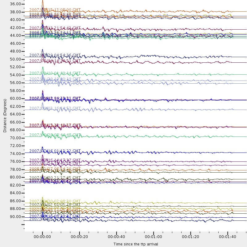
Events Processed for this Station
Download zip of receiver functions as SAC
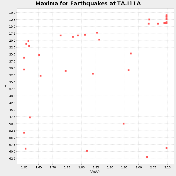
Plot maxima for each earthquake.
Events Used in the Stack
(38 events)| Radial Match | Distance | Baz | FERegion | Time | Lat/Lon | Depth | Magnitude |
| 98.36961 | 89.7 deg | 253.616 deg | Santa Cruz Islands | 2007/09/02 01:05:18 GMT | (-11.6, 165.8) | 35 km | 5.9 MB, 7.3 MS, 7.2 MW, 6.9 ME |
| 98.263695 | 59.9 deg | 306.647 deg | East Of Kuril Islands | 2007/01/13 04:23:21 GMT | (46.2, 154.5) | 10 km | 7.3 MB, 8.2 MS, 8.1 MW, 7.9 MW |
| 96.75458 | 52.8 deg | 129.494 deg | Near West Coast Of Colombia | 2007/09/10 01:49:14 GMT | (3.0, -78.0) | 31 km | 6.1 MB, 6.7 MS, 6.8 MW |
| 95.62617 | 78.2 deg | 137.033 deg | Northern Chile | 2007/11/14 15:40:50 GMT | (-22.2, -69.9) | 40 km | 6.7 MB, 7.4 MS, 7.7 MW, 7.4 ME |
| 95.539825 | 67.4 deg | 138.04 deg | Near Coast Of Peru | 2007/08/15 23:40:57 GMT | (-13.4, -76.6) | 39 km | 6.7 MB, 7.9 MS, 8.0 MW, 7.5 ME |
| 95.52346 | 55.3 deg | 311.529 deg | Kamchatka Peninsula, Russia | 2007/05/30 20:22:12 GMT | (52.1, 157.3) | 116 km | 6.4 MB, 6.4 MW, 6.4 MW |
| 94.72879 | 54.5 deg | 104.261 deg | Windward Islands | 2007/11/29 19:00:19 GMT | (15.0, -61.3) | 148 km | 6.9 MB, 7.4 MW, 7.4 MW |
| 94.61447 | 92.9 deg | 259.21 deg | Solomon Islands | 2007/08/16 08:39:27 GMT | (-9.8, 159.5) | 10 km | 6.1 MB, 6.7 MS, 6.4 MW |
| 94.47329 | 88.8 deg | 283.224 deg | South Of Mariana Islands | 2007/09/30 02:08:30 GMT | (10.5, 145.7) | 14 km | 6.4 MB, 7.1 MS, 6.9 MW, 6.9 MW |
| 94.35016 | 82.8 deg | 293.518 deg | Volcano Islands, Japan Region | 2007/09/28 13:38:59 GMT | (22.0, 142.7) | 276 km | 6.7 MB, 7.4 MW, 7.4 MW |
| 94.301186 | 42.3 deg | 303.399 deg | Andreanof Islands, Aleutian Is. | 2007/12/19 09:30:27 GMT | (51.4, -179.5) | 29 km | 6.4 MB, 7.1 MS, 7.1 MW, 7.0 MW |
| 92.48866 | 90.4 deg | 249.018 deg | Vanuatu Islands | 2007/07/15 09:27:34 GMT | (-15.4, 168.6) | 8.0 km | 6.0 MB, 5.8 MS, 6.1 MW, 6.0 MW |
| 91.852974 | 36.9 deg | 136.504 deg | Near Coast Of Guatemala | 2007/06/08 13:32:00 GMT | (13.8, -90.8) | 48 km | 5.5 MB, 5.4 MS, 5.8 MW, 5.8 MW |
| 91.2903 | 83.2 deg | 289.498 deg | Mariana Islands | 2007/10/31 03:30:17 GMT | (18.9, 145.4) | 223 km | 6.2 MB, 7.2 MW, 7.2 MW |
| 91.100334 | 42.5 deg | 303.434 deg | Andreanof Islands, Aleutian Is. | 2007/08/02 03:21:42 GMT | (51.3, -180.0) | 21 km | 6.3 MB, 6.6 MS, 6.7 MW, 6.6 MW |
| 90.06203 | 41.3 deg | 301.384 deg | Andreanof Islands, Aleutian Is. | 2007/08/15 20:22:11 GMT | (50.3, -177.5) | 9.0 km | 6.3 MB, 6.2 MS, 6.4 MW, 5.9 ML |
| 89.89108 | 40.2 deg | 303.328 deg | Andreanof Islands, Aleutian Is. | 2007/07/13 21:54:43 GMT | (51.8, -176.3) | 35 km | 5.7 MB, 5.6 MS, 6.0 MW, 5.9 MW |
| 89.776474 | 74.6 deg | 307.436 deg | Near West Coast Of Honshu, Japan | 2007/07/16 01:13:22 GMT | (37.5, 138.4) | 12 km | 6.5 MB, 6.4 MS, 6.6 MW, 6.5 MW |
| 88.534294 | 35.1 deg | 302.89 deg | Fox Islands, Aleutian Islands | 2007/07/15 13:08:00 GMT | (52.5, -168.0) | 10 km | 5.8 MB, 5.9 MS, 6.1 MW, 6.0 MW |
| 88.284996 | 49.4 deg | 166.095 deg | Central East Pacific Rise | 2007/08/04 14:24:51 GMT | (-4.8, -105.4) | 10 km | 5.7 MS, 5.4 MB, 6.0 MW, 5.9 MW |
| 87.61281 | 77.2 deg | 308.986 deg | Sea Of Japan | 2007/07/16 14:17:37 GMT | (36.8, 134.9) | 350 km | 6.2 MB, 6.8 MW, 6.8 MW |
| 87.356316 | 41.9 deg | 303.256 deg | Andreanof Islands, Aleutian Is. | 2007/12/21 07:24:34 GMT | (51.4, -179.0) | 30 km | 6.1 MB, 6.2 MW, 6.3 ML |
| 85.6561 | 36.6 deg | 136.985 deg | Near Coast Of Guatemala | 2006/12/03 20:52:15 GMT | (14.0, -91.2) | 61 km | 5.8 MB, 5.9 MW, 5.9 MW |
| 85.58466 | 80.2 deg | 133.733 deg | Jujuy Province, Argentina | 2007/07/21 15:34:52 GMT | (-22.2, -65.8) | 290 km | 5.8 MB, 6.4 MW, 6.3 MW |
| 84.97857 | 41.6 deg | 304.381 deg | Andreanof Islands, Aleutian Is. | 2008/03/22 21:24:11 GMT | (52.2, -178.7) | 132 km | 5.8 MB, 6.2 MW, 6.1 MW |
| 84.957344 | 93.7 deg | 309.046 deg | Taiwan Region | 2007/09/06 17:51:26 GMT | (24.3, 122.2) | 53 km | 6.1 MB, 6.2 MW, 6.1 ME |
| 84.90067 | 42.0 deg | 303.098 deg | Andreanof Islands, Aleutian Is. | 2007/12/21 07:23:35 GMT | (51.2, -179.0) | 30 km | 5.7 MB, 5.5 ML |
| 84.639656 | 36.3 deg | 137.253 deg | Guatemala | 2008/01/05 01:56:45 GMT | (14.1, -91.5) | 66 km | 5.6 MW, 5.4 MB, 5.6 MW |
| 84.28581 | 79.6 deg | 297.13 deg | Bonin Islands, Japan Region | 2008/02/27 06:54:20 GMT | (26.8, 142.4) | 15 km | 5.8 MB, 6.1 MS, 6.2 MW, 6.2 MW |
| 83.99185 | 62.7 deg | 308.275 deg | Kuril Islands | 2007/09/03 16:14:53 GMT | (45.8, 150.1) | 94 km | 6.3 MB, 6.2 MW, 6.2 ME |
| 82.73844 | 36.4 deg | 136.299 deg | Guatemala | 2007/07/23 22:30:08 GMT | (14.4, -91.0) | 113 km | 5.5 MW, 5.3 MB, 5.5 MW |
| 82.140686 | 91.7 deg | 256.572 deg | Solomon Islands | 2007/11/27 11:49:58 GMT | (-10.9, 162.1) | 16 km | 5.9 MB, 6.7 MS, 6.6 MW, 6.4 MW |
| 81.94274 | 82.2 deg | 291.445 deg | Mariana Islands | 2007/01/30 21:37:45 GMT | (21.0, 144.7) | 30 km | 6.3 MB, 6.5 MS, 6.6 MW, 6.5 MW |
| 81.91382 | 91.1 deg | 234.492 deg | South Of Fiji Islands | 2007/10/16 21:05:43 GMT | (-25.8, 179.5) | 509 km | 6.2 MB, 6.6 MW, 6.5 MW |
| 80.97858 | 60.0 deg | 306.621 deg | East Of Kuril Islands | 2006/12/07 19:10:21 GMT | (46.2, 154.4) | 16 km | 6.3 MB, 6.1 MS, 6.3 MW, 6.3 MW |
| 80.59706 | 70.2 deg | 137.727 deg | Near Coast Of Peru | 2007/06/28 08:44:48 GMT | (-15.7, -74.9) | 27 km | 5.5 MB, 5.3 MS, 5.8 MW, 5.8 MW |
| 80.51291 | 47.8 deg | 309.318 deg | Komandorskiye Ostrova Region | 2007/07/29 04:54:36 GMT | (53.6, 169.7) | 26 km | 6.0 MB, 5.5 MS, 5.9 MW, 5.8 MW |
| 80.35677 | 67.6 deg | 138.154 deg | Near Coast Of Peru | 2007/08/17 13:18:13 GMT | (-13.6, -76.6) | 48 km | 5.6 MB, 5.6 MS, 5.9 MW |
Losers
(0 events)| Radial Match | Distance | Baz | FERegion | Time | Lat/Lon | Depth | Magnitude | Reason |
