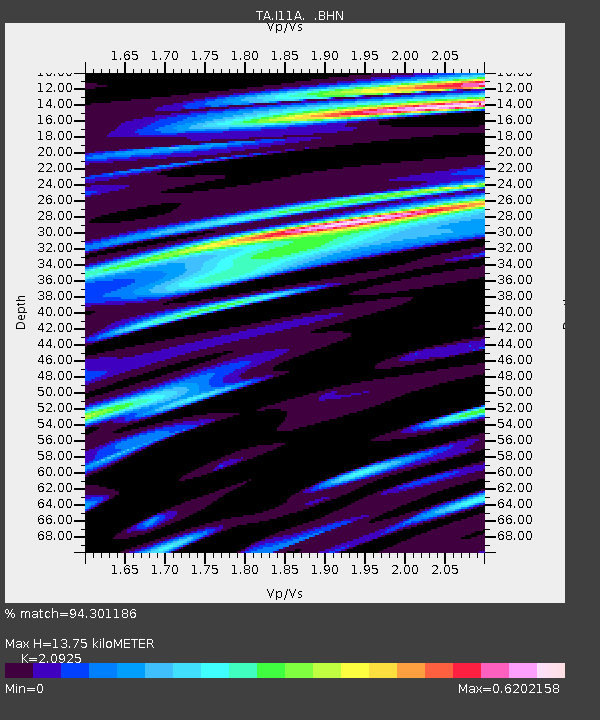
I11A Placerville, ID, USA - Earthquake Result Viewer
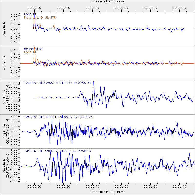
Earthquake location: Andreanof Islands, Aleutian Is.
Earthquake latitude/longitude: 51.4/-179.5
Earthquake time(UTC): 2007/12/19 (353) 09:30:27 GMT
Earthquake Depth: 29 km
Earthquake Magnitude: 6.4 MB, 7.1 MS, 7.1 MW, 7.0 MW
Earthquake Catalog/Contributor: WHDF/NEIC
Network: TA USArray Transportable Network (new EarthScope stations)
Station: I11A Placerville, ID, USA
Lat/Lon: 43.91 N/115.96 W
Elevation: 1288 m
Distance: 42.3 deg
Az: 74.241 deg
Baz: 303.399 deg
Ray Param: 0.07322899
Estimated Moho Depth: 13.75 km
Estimated Crust Vp/Vs: 2.09
Assumed Crust Vp: 6.291 km/s
Estimated Crust Vs: 3.007 km/s
Estimated Crust Poisson's Ratio: 0.35
Radial Match: 94.301186 %
Radial Bump: 400
Transverse Match: 77.07387 %
Transverse Bump: 400
SOD ConfigId: 2564
Insert Time: 2010-03-07 03:58:11.765 +0000
GWidth: 2.5
Max Bumps: 400
Tol: 0.001

Signal To Noise

ChannelStoNSTALTA
TA:I11A: :BHN:20071219T09:37:47.275015Z4.97548961.7679664E-63.5533515E-7
TA:I11A: :BHE:20071219T09:37:47.275015Z4.9130151.8947906E-63.8566756E-7
TA:I11A: :BHZ:20071219T09:37:47.275015Z5.82565643.4727104E-65.961063E-7
Arrivals
Ps2.5 SECOND
PpPs6.4 SECOND
PsPs/PpSs8.9 SECOND