You are here: Home > Network List > TA - USArray Transportable Network (new EarthScope stations) Stations List
> Station I11A Placerville, ID, USA > Earthquake Result Viewer
I11A Placerville, ID, USA - Earthquake Result Viewer
| Earthquake location: |
Northern Chile |
| Earthquake latitude/longitude: |
-22.2/-69.9 |
| Earthquake time(UTC): |
2007/11/14 (318) 15:40:50 GMT |
| Earthquake Depth: |
40 km |
| Earthquake Magnitude: |
6.7 MB, 7.4 MS, 7.7 MW, 7.4 ME |
| Earthquake Catalog/Contributor: |
WHDF/NEIC |
|
| Network: |
TA USArray Transportable Network (new EarthScope stations) |
| Station: |
I11A Placerville, ID, USA |
| Lat/Lon: |
43.91 N/115.96 W |
| Elevation: |
1288 m |
|
| Distance: |
78.2 deg |
| Az: |
327.879 deg |
| Baz: |
137.033 deg |
| Ray Param: |
0.04973568 |
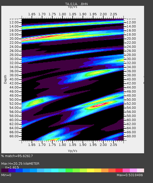
| Estimated Moho Depth: |
20.25 km |
| Estimated Crust Vp/Vs: |
1.62 |
| Assumed Crust Vp: |
6.291 km/s |
| Estimated Crust Vs: |
3.896 km/s |
| Estimated Crust Poisson's Ratio: |
0.19 |
|
| Radial Match: |
95.62617 % |
| Radial Bump: |
363 |
| Transverse Match: |
84.18466 % |
| Transverse Bump: |
400 |
| SOD ConfigId: |
2564 |
| Insert Time: |
2010-03-07 03:58:20.507 +0000 |
| GWidth: |
2.5 |
| Max Bumps: |
400 |
| Tol: |
0.001 |
|
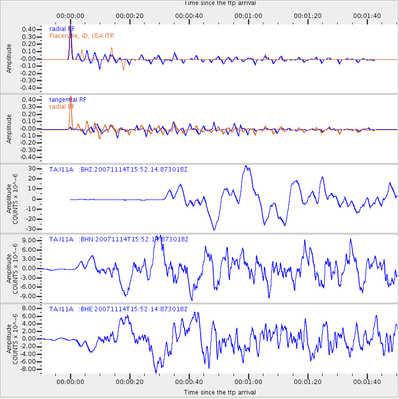
Signal To Noise
| Channel | StoN | STA | LTA |
| TA:I11A: :BHN:20071114T15:52:14.873018Z | 8.6392765 | 1.1340752E-6 | 1.312697E-7 |
| TA:I11A: :BHE:20071114T15:52:14.873018Z | 5.127937 | 8.396385E-7 | 1.6373808E-7 |
| TA:I11A: :BHZ:20071114T15:52:14.873018Z | 23.710718 | 4.2580677E-6 | 1.7958409E-7 |
| Arrivals |
| Ps | 2.0 SECOND |
| PpPs | 8.2 SECOND |
| PsPs/PpSs | 10 SECOND |


