You are here: Home > Network List > TA - USArray Transportable Network (new EarthScope stations) Stations List
> Station I11A Placerville, ID, USA > Earthquake Result Viewer
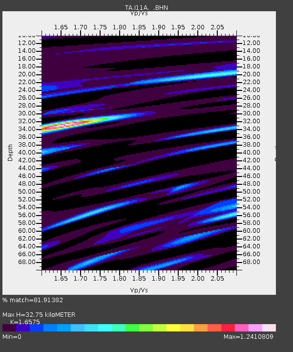
I11A Placerville, ID, USA - Earthquake Result Viewer
| Earthquake location: |
South Of Fiji Islands |
| Earthquake latitude/longitude: |
-25.8/179.5 |
| Earthquake time(UTC): |
2007/10/16 (289) 21:05:43 GMT |
| Earthquake Depth: |
509 km |
| Earthquake Magnitude: |
6.2 MB, 6.6 MW, 6.5 MW |
| Earthquake Catalog/Contributor: |
WHDF/NEIC |
|
| Network: |
TA USArray Transportable Network (new EarthScope stations) |
| Station: |
I11A Placerville, ID, USA |
| Lat/Lon: |
43.91 N/115.96 W |
| Elevation: |
1288 m |
|
| Distance: |
91.1 deg |
| Az: |
40.73 deg |
| Baz: |
234.492 deg |
| Ray Param: |
0.041362133 |
| Estimated Moho Depth: |
32.75 km |
| Estimated Crust Vp/Vs: |
1.66 |
| Assumed Crust Vp: |
6.291 km/s |
| Estimated Crust Vs: |
3.796 km/s |
| Estimated Crust Poisson's Ratio: |
0.21 |
|
| Radial Match: |
81.91382 % |
| Radial Bump: |
380 |
| Transverse Match: |
86.34681 % |
| Transverse Bump: |
400 |
| SOD ConfigId: |
2564 |
| Insert Time: |
2010-03-07 03:58:24.699 +0000 |
| GWidth: |
2.5 |
| Max Bumps: |
400 |
| Tol: |
0.001 |
|

Signal To Noise
| Channel | StoN | STA | LTA |
| TA:I11A: :BHN:20071016T21:17:21.574016Z | 3.309042 | 4.742585E-7 | 1.43322E-7 |
| TA:I11A: :BHE:20071016T21:17:21.574016Z | 6.1621165 | 7.226779E-7 | 1.17277544E-7 |
| TA:I11A: :BHZ:20071016T21:17:21.574016Z | 18.236998 | 2.886298E-6 | 1.5826608E-7 |
| Arrivals |
| Ps | 3.5 SECOND |
| PpPs | 14 SECOND |
| PsPs/PpSs | 17 SECOND |


