I11A Placerville, ID, USA - Earthquake Result Viewer
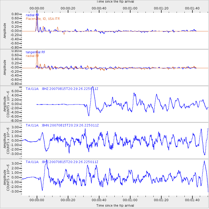
Earthquake location: Andreanof Islands, Aleutian Is.
Earthquake latitude/longitude: 50.3/-177.5
Earthquake time(UTC): 2007/08/15 (227) 20:22:11 GMT
Earthquake Depth: 9.0 km
Earthquake Magnitude: 6.3 MB, 6.2 MS, 6.4 MW, 5.9 ML
Earthquake Catalog/Contributor: WHDF/NEIC
Network: TA USArray Transportable Network (new EarthScope stations)
Station: I11A Placerville, ID, USA
Lat/Lon: 43.91 N/115.96 W
Elevation: 1288 m
Distance: 41.3 deg
Az: 74.265 deg
Baz: 301.384 deg
Ray Param: 0.07386065
Estimated Moho Depth: 47.75 km
Estimated Crust Vp/Vs: 1.62
Assumed Crust Vp: 6.291 km/s
Estimated Crust Vs: 3.883 km/s
Estimated Crust Poisson's Ratio: 0.19
Radial Match: 90.06203 %
Radial Bump: 330
Transverse Match: 64.78699 %
Transverse Bump: 400
SOD ConfigId: 2564
Insert Time: 2010-03-07 03:58:43.486 +0000
GWidth: 2.5
Max Bumps: 400
Tol: 0.001

Signal To Noise

ChannelStoNSTALTA
TA:I11A: :BHN:20070815T20:29:26.225011Z6.15936238.208093E-71.3326206E-7
TA:I11A: :BHE:20070815T20:29:26.225011Z8.1820219.721178E-71.18811464E-7
TA:I11A: :BHZ:20070815T20:29:26.225011Z33.226422.2705021E-66.833424E-8
Arrivals
Ps5.1 SECOND
PpPs18 SECOND
PsPs/PpSs24 SECOND