You are here: Home > Network List > TA - USArray Transportable Network (new EarthScope stations) Stations List
> Station I11A Placerville, ID, USA > Earthquake Result Viewer
I11A Placerville, ID, USA - Earthquake Result Viewer
| Earthquake location: |
Central East Pacific Rise |
| Earthquake latitude/longitude: |
-4.8/-105.4 |
| Earthquake time(UTC): |
2007/08/04 (216) 14:24:51 GMT |
| Earthquake Depth: |
10 km |
| Earthquake Magnitude: |
5.7 MS, 5.4 MB, 6.0 MW, 5.9 MW |
| Earthquake Catalog/Contributor: |
WHDF/NEIC |
|
| Network: |
TA USArray Transportable Network (new EarthScope stations) |
| Station: |
I11A Placerville, ID, USA |
| Lat/Lon: |
43.91 N/115.96 W |
| Elevation: |
1288 m |
|
| Distance: |
49.4 deg |
| Az: |
349.963 deg |
| Baz: |
166.095 deg |
| Ray Param: |
0.06871802 |
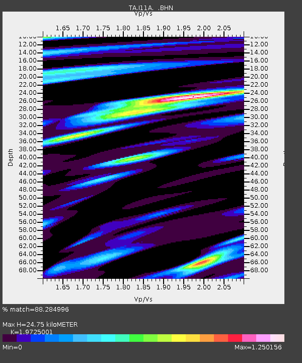
| Estimated Moho Depth: |
24.75 km |
| Estimated Crust Vp/Vs: |
1.97 |
| Assumed Crust Vp: |
6.291 km/s |
| Estimated Crust Vs: |
3.189 km/s |
| Estimated Crust Poisson's Ratio: |
0.33 |
|
| Radial Match: |
88.284996 % |
| Radial Bump: |
400 |
| Transverse Match: |
80.98229 % |
| Transverse Bump: |
400 |
| SOD ConfigId: |
2564 |
| Insert Time: |
2010-03-07 03:58:44.893 +0000 |
| GWidth: |
2.5 |
| Max Bumps: |
400 |
| Tol: |
0.001 |
|

Signal To Noise
| Channel | StoN | STA | LTA |
| TA:I11A: :BHN:20070804T14:33:10.574012Z | 1.6498364 | 1.0048087E-7 | 6.090353E-8 |
| TA:I11A: :BHE:20070804T14:33:10.574012Z | 0.7382916 | 5.1056386E-8 | 6.9154765E-8 |
| TA:I11A: :BHZ:20070804T14:33:10.574012Z | 1.3634628 | 1.2922972E-7 | 9.4780525E-8 |
| Arrivals |
| Ps | 4.0 SECOND |
| PpPs | 11 SECOND |
| PsPs/PpSs | 15 SECOND |


