I11A Placerville, ID, USA - Earthquake Result Viewer
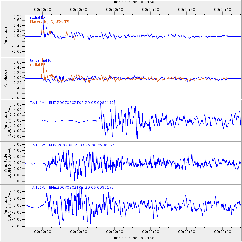
Earthquake location: Andreanof Islands, Aleutian Is.
Earthquake latitude/longitude: 51.3/-180.0
Earthquake time(UTC): 2007/08/02 (214) 03:21:42 GMT
Earthquake Depth: 21 km
Earthquake Magnitude: 6.3 MB, 6.6 MS, 6.7 MW, 6.6 MW
Earthquake Catalog/Contributor: WHDF/NEIC
Network: TA USArray Transportable Network (new EarthScope stations)
Station: I11A Placerville, ID, USA
Lat/Lon: 43.91 N/115.96 W
Elevation: 1288 m
Distance: 42.5 deg
Az: 73.916 deg
Baz: 303.434 deg
Ray Param: 0.073088236
Estimated Moho Depth: 53.25 km
Estimated Crust Vp/Vs: 1.60
Assumed Crust Vp: 6.291 km/s
Estimated Crust Vs: 3.932 km/s
Estimated Crust Poisson's Ratio: 0.18
Radial Match: 91.100334 %
Radial Bump: 383
Transverse Match: 77.95806 %
Transverse Bump: 400
SOD ConfigId: 2564
Insert Time: 2010-03-07 03:58:47.058 +0000
GWidth: 2.5
Max Bumps: 400
Tol: 0.001

Signal To Noise

ChannelStoNSTALTA
TA:I11A: :BHN:20070802T03:29:06.098015Z3.21612629.000109E-72.7984316E-7
TA:I11A: :BHE:20070802T03:29:06.098015Z8.3026611.5878624E-61.912474E-7
TA:I11A: :BHZ:20070802T03:29:06.098015Z10.4065682.5168417E-62.418513E-7
Arrivals
Ps5.5 SECOND
PpPs20 SECOND
PsPs/PpSs26 SECOND