You are here: Home > Network List > TA - USArray Transportable Network (new EarthScope stations) Stations List
> Station I11A Placerville, ID, USA > Earthquake Result Viewer
I11A Placerville, ID, USA - Earthquake Result Viewer
| Earthquake location: |
Komandorskiye Ostrova Region |
| Earthquake latitude/longitude: |
53.6/169.7 |
| Earthquake time(UTC): |
2007/07/29 (210) 04:54:36 GMT |
| Earthquake Depth: |
26 km |
| Earthquake Magnitude: |
6.0 MB, 5.5 MS, 5.9 MW, 5.8 MW |
| Earthquake Catalog/Contributor: |
WHDF/NEIC |
|
| Network: |
TA USArray Transportable Network (new EarthScope stations) |
| Station: |
I11A Placerville, ID, USA |
| Lat/Lon: |
43.91 N/115.96 W |
| Elevation: |
1288 m |
|
| Distance: |
47.8 deg |
| Az: |
69.891 deg |
| Baz: |
309.318 deg |
| Ray Param: |
0.069704905 |
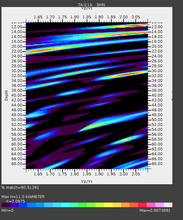
| Estimated Moho Depth: |
11.0 km |
| Estimated Crust Vp/Vs: |
2.10 |
| Assumed Crust Vp: |
6.291 km/s |
| Estimated Crust Vs: |
2.999 km/s |
| Estimated Crust Poisson's Ratio: |
0.35 |
|
| Radial Match: |
80.51291 % |
| Radial Bump: |
400 |
| Transverse Match: |
80.79255 % |
| Transverse Bump: |
400 |
| SOD ConfigId: |
2564 |
| Insert Time: |
2010-03-07 03:58:49.396 +0000 |
| GWidth: |
2.5 |
| Max Bumps: |
400 |
| Tol: |
0.001 |
|

Signal To Noise
| Channel | StoN | STA | LTA |
| TA:I11A: :BHN:20070729T05:02:41.275002Z | 2.3957162 | 1.9863894E-7 | 8.291422E-8 |
| TA:I11A: :BHE:20070729T05:02:41.275002Z | 1.7362771 | 1.6330868E-7 | 9.405681E-8 |
| TA:I11A: :BHZ:20070729T05:02:41.275002Z | 6.691185 | 3.4605844E-7 | 5.1718555E-8 |
| Arrivals |
| Ps | 2.0 SECOND |
| PpPs | 5.2 SECOND |
| PsPs/PpSs | 7.2 SECOND |


