You are here: Home > Network List > TA - USArray Transportable Network (new EarthScope stations) Stations List
> Station I11A Placerville, ID, USA > Earthquake Result Viewer
I11A Placerville, ID, USA - Earthquake Result Viewer
| Earthquake location: |
Near Coast Of Guatemala |
| Earthquake latitude/longitude: |
14.0/-91.2 |
| Earthquake time(UTC): |
2006/12/03 (337) 20:52:15 GMT |
| Earthquake Depth: |
61 km |
| Earthquake Magnitude: |
5.8 MB, 5.9 MW, 5.9 MW |
| Earthquake Catalog/Contributor: |
WHDF/NEIC |
|
| Network: |
TA USArray Transportable Network (new EarthScope stations) |
| Station: |
I11A Placerville, ID, USA |
| Lat/Lon: |
43.91 N/115.96 W |
| Elevation: |
1288 m |
|
| Distance: |
36.6 deg |
| Az: |
329.475 deg |
| Baz: |
136.985 deg |
| Ray Param: |
0.076442525 |
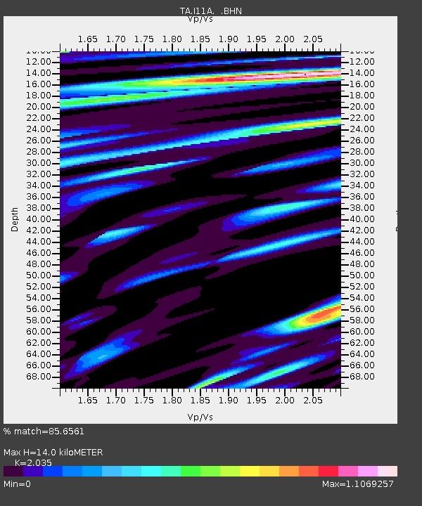
| Estimated Moho Depth: |
14.0 km |
| Estimated Crust Vp/Vs: |
2.04 |
| Assumed Crust Vp: |
6.291 km/s |
| Estimated Crust Vs: |
3.092 km/s |
| Estimated Crust Poisson's Ratio: |
0.34 |
|
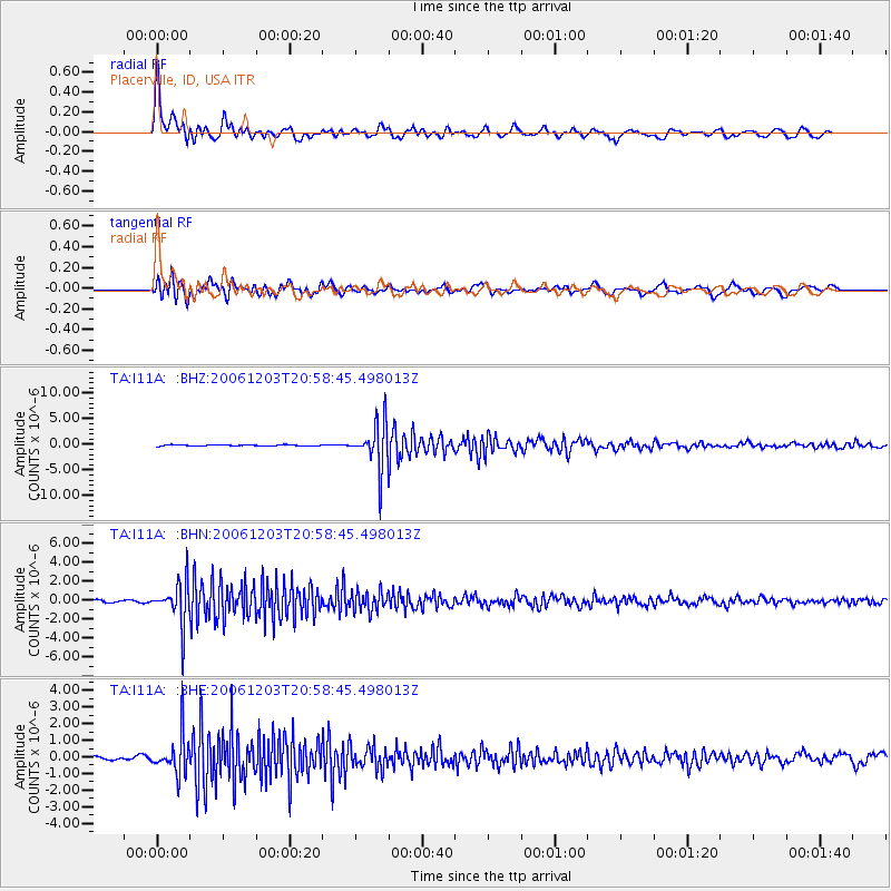
| Radial Match: |
85.6561 % |
| Radial Bump: |
400 |
| Transverse Match: |
82.103165 % |
| Transverse Bump: |
400 |
| SOD ConfigId: |
2564 |
| Insert Time: |
2010-03-07 03:59:16.658 +0000 |
| GWidth: |
2.5 |
| Max Bumps: |
400 |
| Tol: |
0.001 |
|
Signal To Noise
| Channel | StoN | STA | LTA |
| TA:I11A: :BHN:20061203T20:58:45.498013Z | 11.901125 | 2.2013837E-6 | 1.8497275E-7 |
| TA:I11A: :BHE:20061203T20:58:45.498013Z | 7.9124193 | 1.1620871E-6 | 1.4686874E-7 |
| TA:I11A: :BHZ:20061203T20:58:45.498013Z | 41.816837 | 4.4106E-6 | 1.05474264E-7 |
| Arrivals |
| Ps | 2.4 SECOND |
| PpPs | 6.4 SECOND |
| PsPs/PpSs | 8.8 SECOND |


