You are here: Home > Network List > TA - USArray Transportable Network (new EarthScope stations) Stations List
> Station L22K Petersville, AK, USA > Earthquake Result Viewer
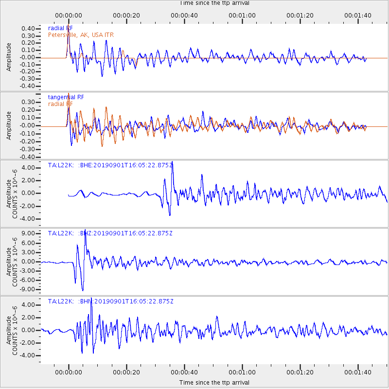
L22K Petersville, AK, USA - Earthquake Result Viewer
*The percent match for this event was below the threshold and hence no stack was calculated.
| Earthquake location: |
Fiji Islands Region |
| Earthquake latitude/longitude: |
-20.4/-178.4 |
| Earthquake time(UTC): |
2019/09/01 (244) 15:54:20 GMT |
| Earthquake Depth: |
617 km |
| Earthquake Magnitude: |
6.5 Mi |
| Earthquake Catalog/Contributor: |
NEIC PDE/at |
|
| Network: |
TA USArray Transportable Network (new EarthScope stations) |
| Station: |
L22K Petersville, AK, USA |
| Lat/Lon: |
62.53 N/150.77 W |
| Elevation: |
817 m |
|
| Distance: |
85.5 deg |
| Az: |
12.46 deg |
| Baz: |
205.872 deg |
| Ray Param: |
$rayparam |
*The percent match for this event was below the threshold and hence was not used in the summary stack. |
|
| Radial Match: |
88.426674 % |
| Radial Bump: |
400 |
| Transverse Match: |
83.66462 % |
| Transverse Bump: |
400 |
| SOD ConfigId: |
19053131 |
| Insert Time: |
2019-09-15 16:04:27.766 +0000 |
| GWidth: |
2.5 |
| Max Bumps: |
400 |
| Tol: |
0.001 |
|
Signal To Noise
| Channel | StoN | STA | LTA |
| TA:L22K: :BHZ:20190901T16:05:22.875Z | 19.840605 | 3.4290338E-6 | 1.728291E-7 |
| TA:L22K: :BHN:20190901T16:05:22.875Z | 4.404254 | 1.1024858E-6 | 2.5032296E-7 |
| TA:L22K: :BHE:20190901T16:05:22.875Z | 5.129532 | 1.1431448E-6 | 2.2285556E-7 |
| Arrivals |
| Ps | |
| PpPs | |
| PsPs/PpSs | |


