You are here: Home > Network List > TA - USArray Transportable Network (new EarthScope stations) Stations List
> Station I10A Payette, ID, USA > Earthquake Result Viewer
I10A Payette, ID, USA - Earthquake Result Viewer
| Earthquake location: |
South Of Fiji Islands |
| Earthquake latitude/longitude: |
-26.0/-177.5 |
| Earthquake time(UTC): |
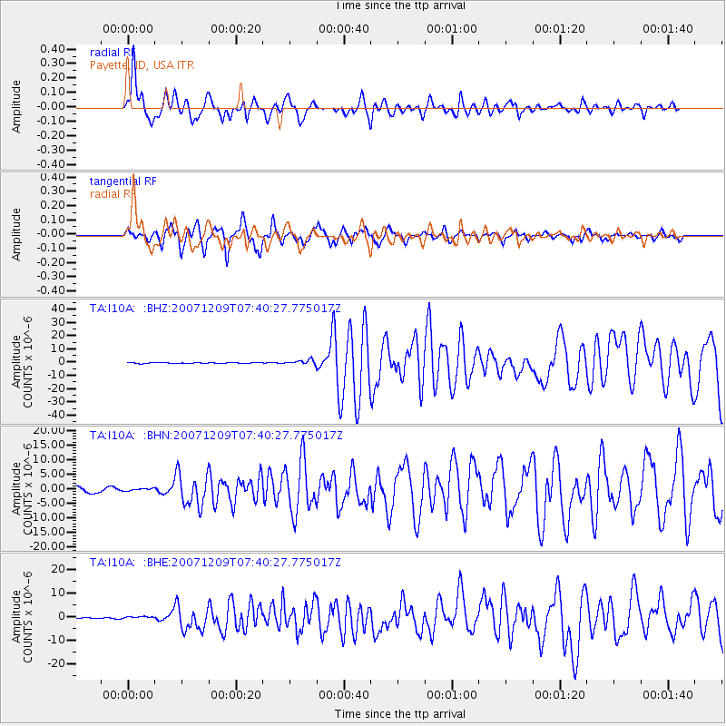
2007/12/09 (343) 07:28:20 GMT |
| Earthquake Depth: |
152 km |
| Earthquake Magnitude: |
7.0 MB, 7.8 MW, 7.7 MW |
| Earthquake Catalog/Contributor: |
WHDF/NEIC |
|
| Network: |
TA USArray Transportable Network (new EarthScope stations) |
| Station: |
I10A Payette, ID, USA |
| Lat/Lon: |
44.09 N/116.80 W |
| Elevation: |
782 m |
|
| Distance: |
89.1 deg |
| Az: |
38.945 deg |
| Baz: |
231.722 deg |
| Ray Param: |
0.041740026 |
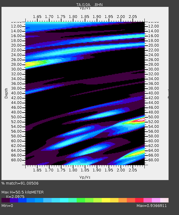
| Estimated Moho Depth: |
50.5 km |
| Estimated Crust Vp/Vs: |
2.10 |
| Assumed Crust Vp: |
6.571 km/s |
| Estimated Crust Vs: |
3.133 km/s |
| Estimated Crust Poisson's Ratio: |
0.35 |
|
| Radial Match: |
91.08506 % |
| Radial Bump: |
400 |
| Transverse Match: |
89.466064 % |
| Transverse Bump: |
400 |
| SOD ConfigId: |
2564 |
| Insert Time: |
2010-03-07 04:01:09.655 +0000 |
| GWidth: |
2.5 |
| Max Bumps: |
400 |
| Tol: |
0.001 |
|
Signal To Noise
| Channel | StoN | STA | LTA |
| TA:I10A: :BHN:20071209T07:40:27.775017Z | 0.37837723 | 4.1829728E-7 | 1.1055033E-6 |
| TA:I10A: :BHE:20071209T07:40:27.775017Z | 0.69675726 | 4.3020117E-7 | 6.1743333E-7 |
| TA:I10A: :BHZ:20071209T07:40:27.775017Z | 6.0537095 | 1.7281703E-6 | 2.8547296E-7 |
| Arrivals |
| Ps | 8.6 SECOND |
| PpPs | 23 SECOND |
| PsPs/PpSs | 32 SECOND |


