
Station TA I10A - Payette, ID, USA
Network: TA - USArray Transportable Network (new EarthScope stations)
Nearby stations (2 deg radius)
| Station | Name | (Lat, Lon) | Start / End | Elevation |
| I10A | Payette, ID, USA | (44.09, -116.80) | 2006-10-26 / 2499-01-01 | 0.8 km |
| Crust2 Type: | Q9,orogen/41km no ice, cordilleras, 0.25 km seds. |
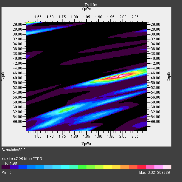
| Thickness Estimate: | 47 km |
| Thickness StdDev: | 8.4 km |
| Vp/Vs Estimate: | 1.98 |
| Vp/Vs StdDev: | 0.12 |
| Vs Estimate: | 3.319 km/s |
| Poisson's Ratio: | 0.33 |
| Peak Value: | 0.02 |
| Assumed Vp: | 6.571 km/s |
| Ps Weight: | 0.33333334 |
| PpPs Weight: | 0.33333334 |
| PsPs Weight: | 0.33333328 |
| Residual Complexity: | 0.595 |
| Nearby stations H: | +- |
| (2.0 deg) Vp/Vs: | +- |
7 with match > 90% ( 53.846153 %) and 12 with match > 80% ( 92.30769 %) out of 13.
Download stack as xyz text file.
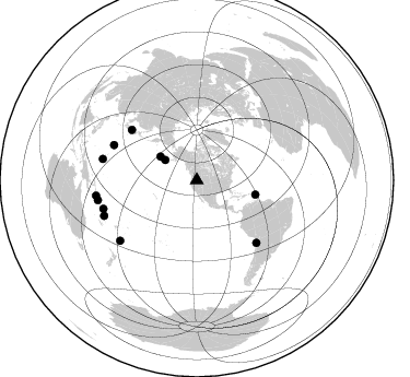
Azimuth Distribution of Events:
Prior Results for this Station
| Study | Thickness | Vp/Vs | Vp | Vs | Poissons Ratio | Extra |
| EARS | 47 km | 1.98 | 6.571 km/s | 3.319 km/s | 0.33 | |
| Crust2.0 | 41 km | 1.76 | 6.571 km/s | 3.735 km/s | 0.26 | Q9,orogen/41km no ice, cordilleras, 0.25 km seds. |
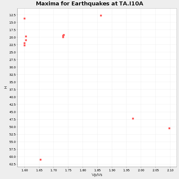
| Global Maxima | 47 km | 1.98 | 6.571 km/s | 3.319 km/s | 0.33 | amp=0.021363636 |
| Local Maxima 1 | 25 km | 1.61 | 6.571 km/s | 4.075 km/s | 0.19 | amp=0.013037137 |
| Local Maxima 2 | 67 km | 1.69 | 6.571 km/s | 3.894 km/s | 0.23 | amp=0.007725193 |
| Local Maxima 3 | 30 km | 1.60 | 6.571 km/s | 4.107 km/s | 0.18 | amp=0.007639549 |
| Local Maxima 4 | 70 km | 1.83 | 6.571 km/s | 3.586 km/s | 0.29 | amp=0.006920962 |
| Predicted Arrivals for vertical incidence (zero ray parameter) | |
| Ps | 7.05 SECOND |
| PpPs | 21.43 SECOND |
| PsPs/PpSs | 28.48 SECOND |
Events Processed for this Station
Download zip of receiver functions as SAC
Plot maxima for each earthquake.
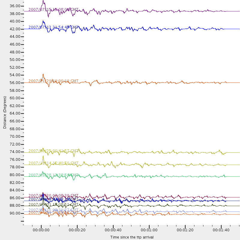
Events Used in the Stack
(12 events)| Radial Match | Distance | Baz | FERegion | Time | Lat/Lon | Depth | Magnitude |
| 95.09738 | 93.1 deg | 261.283 deg | Solomon Islands | 2007/04/01 20:39:56 GMT | (-8.5, 157.0) | 10 km | 6.8 MB, 7.9 MS, 8.1 MW, 7.7 ME |
| 93.95366 | 90.7 deg | 248.922 deg | Vanuatu Islands | 2007/08/01 17:08:51 GMT | (-15.6, 167.7) | 120 km | 6.2 MB, 7.2 MW, 7.2 MW |
| 92.06392 | 89.1 deg | 253.028 deg | Santa Cruz Islands | 2007/09/02 01:05:18 GMT | (-11.6, 165.8) | 35 km | 5.9 MB, 7.3 MS, 7.2 MW, 6.9 ME |
| 91.682396 | 78.8 deg | 136.382 deg | Northern Chile | 2007/11/14 15:40:50 GMT | (-22.2, -69.9) | 40 km | 6.7 MB, 7.4 MS, 7.7 MW, 7.4 ME |
| 91.08506 | 89.1 deg | 231.722 deg | South Of Fiji Islands | 2007/12/09 07:28:20 GMT | (-26.0, -177.5) | 152 km | 7.0 MB, 7.8 MW, 7.7 MW |
| 90.898994 | 82.2 deg | 292.943 deg | Volcano Islands, Japan Region | 2007/09/28 13:38:59 GMT | (22.0, 142.7) | 276 km | 6.7 MB, 7.4 MW, 7.4 MW |
| 90.17509 | 92.3 deg | 258.638 deg | Solomon Islands | 2007/08/16 08:39:27 GMT | (-9.8, 159.5) | 10 km | 6.1 MB, 6.7 MS, 6.4 MW |
| 89.672005 | 34.5 deg | 302.569 deg | Fox Islands, Aleutian Islands | 2007/07/15 13:08:00 GMT | (52.5, -168.0) | 10 km | 5.8 MB, 5.9 MS, 6.1 MW, 6.0 MW |
| 87.013504 | 55.1 deg | 103.691 deg | Windward Islands | 2007/11/29 19:00:19 GMT | (15.0, -61.3) | 148 km | 6.9 MB, 7.4 MW, 7.4 MW |
| 83.25757 | 88.1 deg | 282.638 deg | South Of Mariana Islands | 2007/09/30 02:08:30 GMT | (10.5, 145.7) | 14 km | 6.4 MB, 7.1 MS, 6.9 MW, 6.9 MW |
| 82.99588 | 39.6 deg | 302.968 deg | Andreanof Islands, Aleutian Is. | 2007/07/13 21:54:43 GMT | (51.8, -176.3) | 35 km | 5.7 MB, 5.6 MS, 6.0 MW, 5.9 MW |
| 80.4624 | 75.3 deg | 307.832 deg | Near West Coast Of Honshu, Japan | 2007/03/25 00:41:57 GMT | (37.3, 136.6) | 8.0 km | 6.1 MB, 6.8 MS, 6.7 MW, 6.6 MW |
Losers
(1 events)| Radial Match | Distance | Baz | FERegion | Time | Lat/Lon | Depth | Magnitude | Reason |
| 88.48906 | 54.7 deg | 311.135 deg | Kamchatka Peninsula, Russia | 2007/05/30 20:22:12 GMT | (52.1, 157.3) | 116 km | 6.4 MB, 6.4 MW, 6.4 MW |
