You are here: Home > Network List > TA - USArray Transportable Network (new EarthScope stations) Stations List
> Station I10A Payette, ID, USA > Earthquake Result Viewer
I10A Payette, ID, USA - Earthquake Result Viewer
| Earthquake location: |
Northern Chile |
| Earthquake latitude/longitude: |
-22.2/-69.9 |
| Earthquake time(UTC): |
2007/11/14 (318) 15:40:50 GMT |
| Earthquake Depth: |
40 km |
| Earthquake Magnitude: |
6.7 MB, 7.4 MS, 7.7 MW, 7.4 ME |
| Earthquake Catalog/Contributor: |
WHDF/NEIC |
|
| Network: |
TA USArray Transportable Network (new EarthScope stations) |
| Station: |
I10A Payette, ID, USA |
| Lat/Lon: |
44.09 N/116.80 W |
| Elevation: |
782 m |
|
| Distance: |
78.8 deg |
| Az: |
327.548 deg |
| Baz: |
136.382 deg |
| Ray Param: |
0.049366422 |
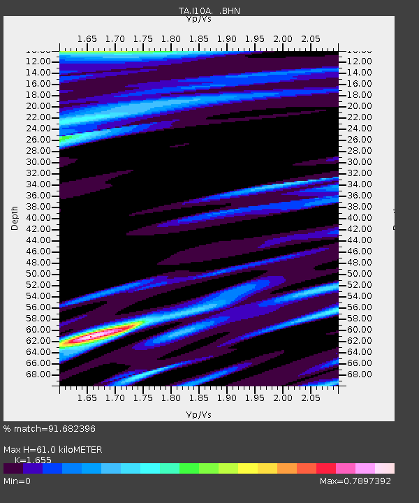
| Estimated Moho Depth: |
61.0 km |
| Estimated Crust Vp/Vs: |
1.65 |
| Assumed Crust Vp: |
6.571 km/s |
| Estimated Crust Vs: |
3.97 km/s |
| Estimated Crust Poisson's Ratio: |
0.21 |
|
| Radial Match: |
91.682396 % |
| Radial Bump: |
400 |
| Transverse Match: |
89.31827 % |
| Transverse Bump: |
400 |
| SOD ConfigId: |
2564 |
| Insert Time: |
2010-03-07 04:01:12.729 +0000 |
| GWidth: |
2.5 |
| Max Bumps: |
400 |
| Tol: |
0.001 |
|
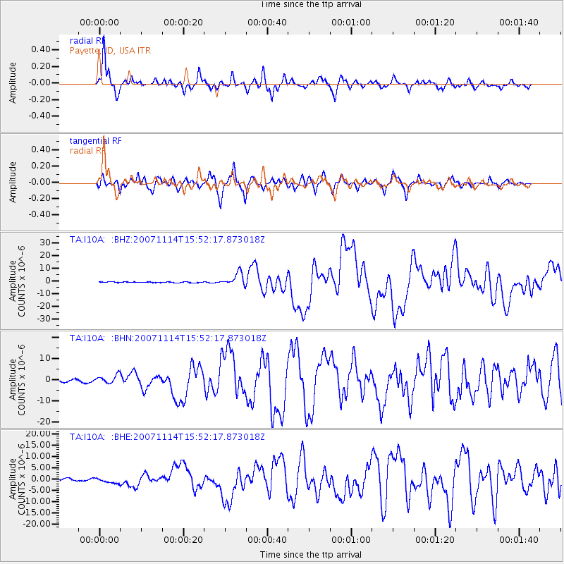
Signal To Noise
| Channel | StoN | STA | LTA |
| TA:I10A: :BHN:20071114T15:52:17.873018Z | 3.5770066 | 2.0537746E-6 | 5.7416014E-7 |
| TA:I10A: :BHE:20071114T15:52:17.873018Z | 1.7195544 | 1.1266858E-6 | 6.5521965E-7 |
| TA:I10A: :BHZ:20071114T15:52:17.873018Z | 15.543075 | 5.2741734E-6 | 3.3932628E-7 |
| Arrivals |
| Ps | 6.3 SECOND |
| PpPs | 24 SECOND |
| PsPs/PpSs | 30 SECOND |


