You are here: Home > Network List > TA - USArray Transportable Network (new EarthScope stations) Stations List
> Station I10A Payette, ID, USA > Earthquake Result Viewer
I10A Payette, ID, USA - Earthquake Result Viewer
| Earthquake location: |
Solomon Islands |
| Earthquake latitude/longitude: |
-9.8/159.5 |
| Earthquake time(UTC): |
2007/08/16 (228) 08:39:27 GMT |
| Earthquake Depth: |
10 km |
| Earthquake Magnitude: |
6.1 MB, 6.7 MS, 6.4 MW |
| Earthquake Catalog/Contributor: |
WHDF/NEIC |
|
| Network: |
TA USArray Transportable Network (new EarthScope stations) |
| Station: |
I10A Payette, ID, USA |
| Lat/Lon: |
44.09 N/116.80 W |
| Elevation: |
782 m |
|
| Distance: |
92.3 deg |
| Az: |
45.798 deg |
| Baz: |
258.638 deg |
| Ray Param: |
0.041479904 |
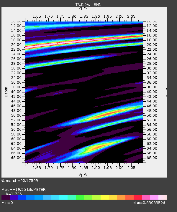
| Estimated Moho Depth: |
19.25 km |
| Estimated Crust Vp/Vs: |
1.74 |
| Assumed Crust Vp: |
6.571 km/s |
| Estimated Crust Vs: |
3.787 km/s |
| Estimated Crust Poisson's Ratio: |
0.25 |
|
| Radial Match: |
90.17509 % |
| Radial Bump: |
393 |
| Transverse Match: |
87.48315 % |
| Transverse Bump: |
384 |
| SOD ConfigId: |
2564 |
| Insert Time: |
2010-03-07 04:01:18.500 +0000 |
| GWidth: |
2.5 |
| Max Bumps: |
400 |
| Tol: |
0.001 |
|
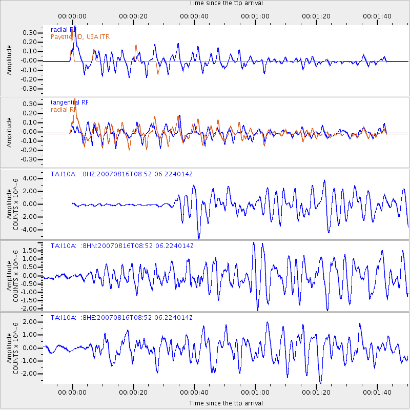
Signal To Noise
| Channel | StoN | STA | LTA |
| TA:I10A: :BHN:20070816T08:52:06.224014Z | 0.93743473 | 1.0520926E-7 | 1.1223103E-7 |
| TA:I10A: :BHE:20070816T08:52:06.224014Z | 0.76764035 | 1.2375504E-7 | 1.6121488E-7 |
| TA:I10A: :BHZ:20070816T08:52:06.224014Z | 4.2157383 | 4.4777485E-7 | 1.0621505E-7 |
| Arrivals |
| Ps | 2.2 SECOND |
| PpPs | 7.8 SECOND |
| PsPs/PpSs | 10 SECOND |


