You are here: Home > Network List > TA - USArray Transportable Network (new EarthScope stations) Stations List
> Station I10A Payette, ID, USA > Earthquake Result Viewer
I10A Payette, ID, USA - Earthquake Result Viewer
| Earthquake location: |
Vanuatu Islands |
| Earthquake latitude/longitude: |
-15.6/167.7 |
| Earthquake time(UTC): |
2007/08/01 (213) 17:08:51 GMT |
| Earthquake Depth: |
120 km |
| Earthquake Magnitude: |
6.2 MB, 7.2 MW, 7.2 MW |
| Earthquake Catalog/Contributor: |
WHDF/NEIC |
|
| Network: |
TA USArray Transportable Network (new EarthScope stations) |
| Station: |
I10A Payette, ID, USA |
| Lat/Lon: |
44.09 N/116.80 W |
| Elevation: |
782 m |
|
| Distance: |
90.7 deg |
| Az: |
44.249 deg |
| Baz: |
248.922 deg |
| Ray Param: |
0.041633144 |
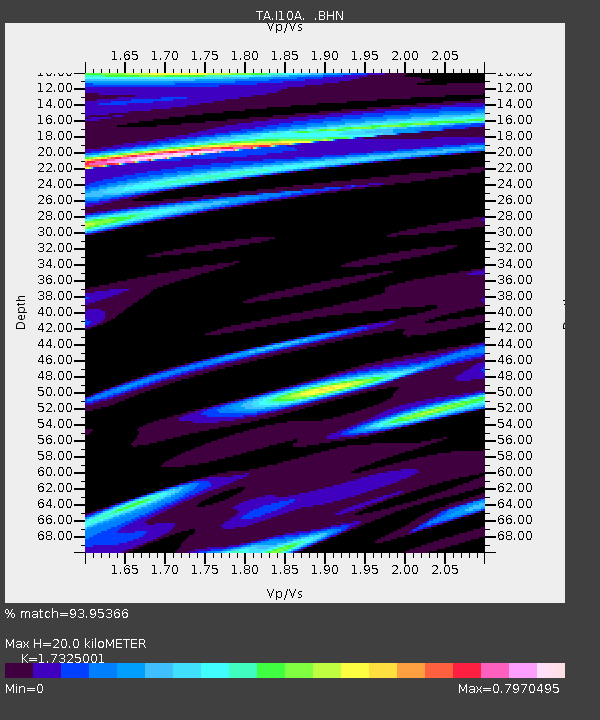
| Estimated Moho Depth: |
20.0 km |
| Estimated Crust Vp/Vs: |
1.73 |
| Assumed Crust Vp: |
6.571 km/s |
| Estimated Crust Vs: |
3.793 km/s |
| Estimated Crust Poisson's Ratio: |
0.25 |
|
| Radial Match: |
93.95366 % |
| Radial Bump: |
400 |
| Transverse Match: |
87.75771 % |
| Transverse Bump: |
400 |
| SOD ConfigId: |
2564 |
| Insert Time: |
2010-03-07 04:01:19.372 +0000 |
| GWidth: |
2.5 |
| Max Bumps: |
400 |
| Tol: |
0.001 |
|
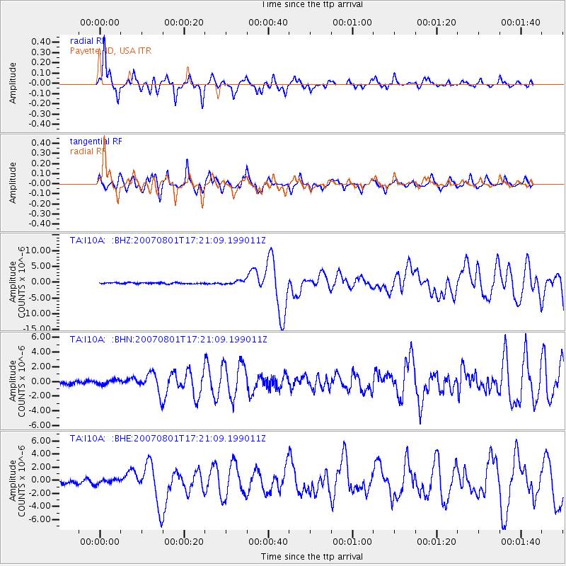
Signal To Noise
| Channel | StoN | STA | LTA |
| TA:I10A: :BHN:20070801T17:21:09.199011Z | 1.0548109 | 3.079805E-7 | 2.91977E-7 |
| TA:I10A: :BHE:20070801T17:21:09.199011Z | 1.6148884 | 3.246335E-7 | 2.0102534E-7 |
| TA:I10A: :BHZ:20070801T17:21:09.199011Z | 3.6320593 | 6.787061E-7 | 1.8686536E-7 |
| Arrivals |
| Ps | 2.3 SECOND |
| PpPs | 8.1 SECOND |
| PsPs/PpSs | 10 SECOND |


