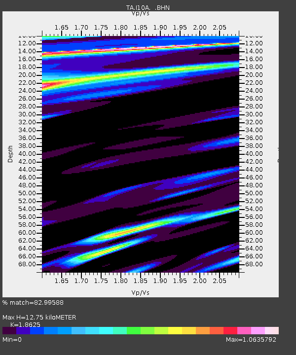
I10A Payette, ID, USA - Earthquake Result Viewer
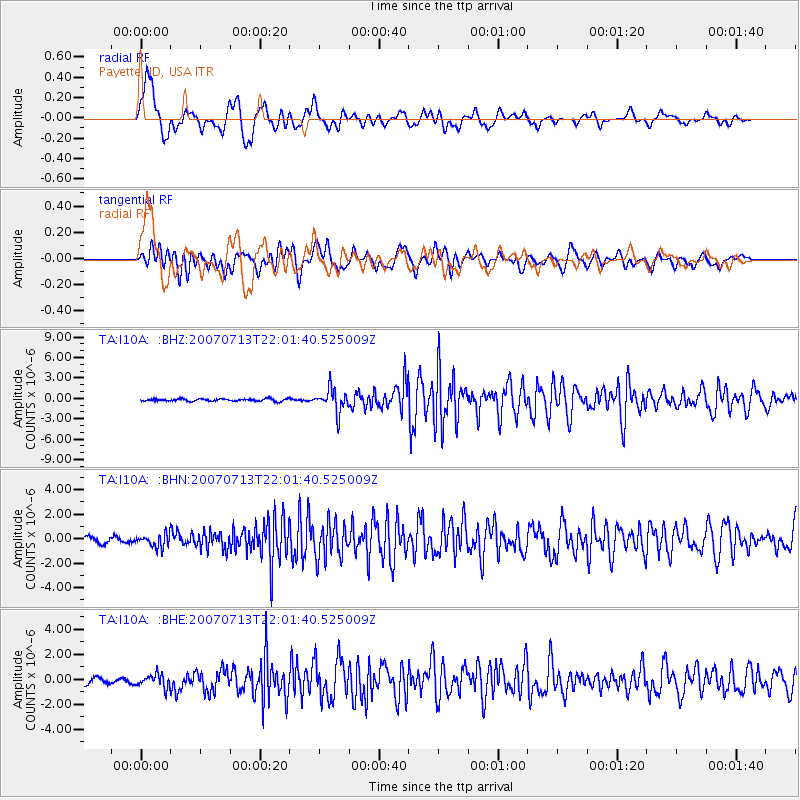
Earthquake location: Andreanof Islands, Aleutian Is.
Earthquake latitude/longitude: 51.8/-176.3
Earthquake time(UTC): 2007/07/13 (194) 21:54:43 GMT
Earthquake Depth: 35 km
Earthquake Magnitude: 5.7 MB, 5.6 MS, 6.0 MW, 5.9 MW
Earthquake Catalog/Contributor: WHDF/NEIC
Network: TA USArray Transportable Network (new EarthScope stations)
Station: I10A Payette, ID, USA
Lat/Lon: 44.09 N/116.80 W
Elevation: 782 m
Distance: 39.6 deg
Az: 77.015 deg
Baz: 302.968 deg
Ray Param: 0.07483803
Estimated Moho Depth: 12.75 km
Estimated Crust Vp/Vs: 1.86
Assumed Crust Vp: 6.571 km/s
Estimated Crust Vs: 3.528 km/s
Estimated Crust Poisson's Ratio: 0.30
Radial Match: 82.99588 %
Radial Bump: 400
Transverse Match: 77.92955 %
Transverse Bump: 400
SOD ConfigId: 2564
Insert Time: 2010-03-07 04:01:24.596 +0000
GWidth: 2.5
Max Bumps: 400
Tol: 0.001

Signal To Noise

ChannelStoNSTALTA
TA:I10A: :BHN:20070713T22:01:40.525009Z1.87926925.389988E-72.8681296E-7
TA:I10A: :BHE:20070713T22:01:40.525009Z1.5062215.144884E-73.4157563E-7
TA:I10A: :BHZ:20070713T22:01:40.525009Z9.915441.7168413E-61.7314828E-7
Arrivals
Ps1.8 SECOND
PpPs5.2 SECOND
PsPs/PpSs7.0 SECOND