You are here: Home > Network List > TA - USArray Transportable Network (new EarthScope stations) Stations List
> Station I10A Payette, ID, USA > Earthquake Result Viewer
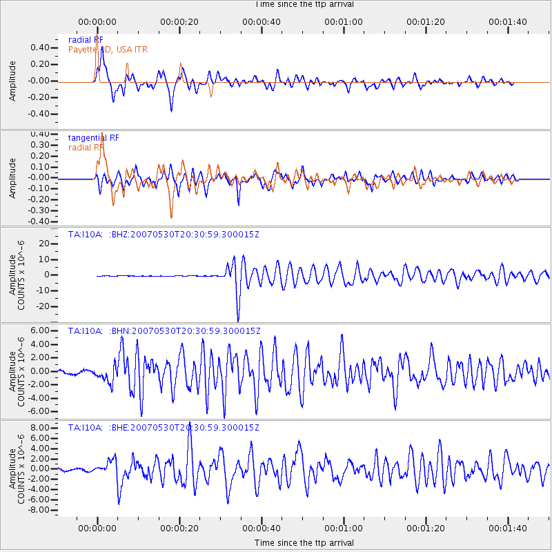
I10A Payette, ID, USA - Earthquake Result Viewer
*The percent match for this event was below the threshold and hence no stack was calculated.
| Earthquake location: |
Kamchatka Peninsula, Russia |
| Earthquake latitude/longitude: |
52.1/157.3 |
| Earthquake time(UTC): |
2007/05/30 (150) 20:22:12 GMT |
| Earthquake Depth: |
116 km |
| Earthquake Magnitude: |
6.4 MB, 6.4 MW, 6.4 MW |
| Earthquake Catalog/Contributor: |
WHDF/NEIC |
|
| Network: |
TA USArray Transportable Network (new EarthScope stations) |
| Station: |
I10A Payette, ID, USA |
| Lat/Lon: |
44.09 N/116.80 W |
| Elevation: |
782 m |
|
| Distance: |
54.7 deg |
| Az: |
61.714 deg |
| Baz: |
311.135 deg |
| Ray Param: |
$rayparam |
*The percent match for this event was below the threshold and hence was not used in the summary stack. |
|
| Radial Match: |
88.48906 % |
| Radial Bump: |
400 |
| Transverse Match: |
85.16906 % |
| Transverse Bump: |
400 |
| SOD ConfigId: |
2564 |
| Insert Time: |
2010-03-07 04:01:25.456 +0000 |
| GWidth: |
2.5 |
| Max Bumps: |
400 |
| Tol: |
0.001 |
|
Signal To Noise
| Channel | StoN | STA | LTA |
| TA:I10A: :BHN:20070530T20:30:59.300015Z | 4.603715 | 1.187675E-6 | 2.579819E-7 |
| TA:I10A: :BHE:20070530T20:30:59.300015Z | 4.6839614 | 1.3863615E-6 | 2.9598053E-7 |
| TA:I10A: :BHZ:20070530T20:30:59.300015Z | 85.93084 | 1.0361253E-5 | 1.2057666E-7 |
| Arrivals |
| Ps | |
| PpPs | |
| PsPs/PpSs | |


