You are here: Home > Network List > TA - USArray Transportable Network (new EarthScope stations) Stations List
> Station I10A Payette, ID, USA > Earthquake Result Viewer
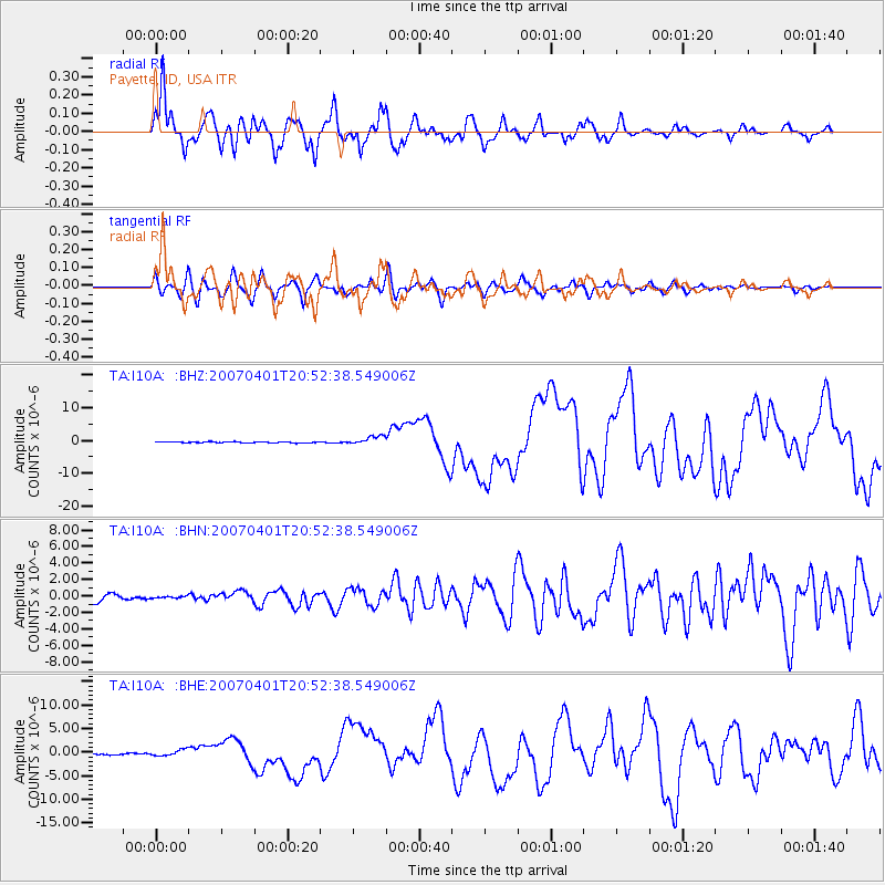
I10A Payette, ID, USA - Earthquake Result Viewer
| Earthquake location: |
Solomon Islands |
| Earthquake latitude/longitude: |
-8.5/157.0 |
| Earthquake time(UTC): |
2007/04/01 (091) 20:39:56 GMT |
| Earthquake Depth: |
10 km |
| Earthquake Magnitude: |
6.8 MB, 7.9 MS, 8.1 MW, 7.7 ME |
| Earthquake Catalog/Contributor: |
WHDF/NEIC |
|
| Network: |
TA USArray Transportable Network (new EarthScope stations) |
| Station: |
I10A Payette, ID, USA |
| Lat/Lon: |
44.09 N/116.80 W |
| Elevation: |
782 m |
|
| Distance: |
93.1 deg |
| Az: |
46.057 deg |
| Baz: |
261.283 deg |
| Ray Param: |
0.04133408 |
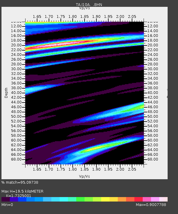
| Estimated Moho Depth: |
19.5 km |
| Estimated Crust Vp/Vs: |
1.73 |
| Assumed Crust Vp: |
6.571 km/s |
| Estimated Crust Vs: |
3.793 km/s |
| Estimated Crust Poisson's Ratio: |
0.25 |
|
| Radial Match: |
95.09738 % |
| Radial Bump: |
400 |
| Transverse Match: |
78.966194 % |
| Transverse Bump: |
400 |
| SOD ConfigId: |
2564 |
| Insert Time: |
2010-03-07 04:01:26.749 +0000 |
| GWidth: |
2.5 |
| Max Bumps: |
400 |
| Tol: |
0.001 |
|
Signal To Noise
| Channel | StoN | STA | LTA |
| TA:I10A: :BHN:20070401T20:52:38.549006Z | 0.26468015 | 1.2265747E-7 | 4.634177E-7 |
| TA:I10A: :BHE:20070401T20:52:38.549006Z | 2.3403938 | 6.1912414E-7 | 2.6453847E-7 |
| TA:I10A: :BHZ:20070401T20:52:38.549006Z | 7.609442 | 1.3160229E-6 | 1.7294605E-7 |
| Arrivals |
| Ps | 2.2 SECOND |
| PpPs | 7.9 SECOND |
| PsPs/PpSs | 10 SECOND |


