You are here: Home > Network List > TA - USArray Transportable Network (new EarthScope stations) Stations List
> Station A07A Ashnola River, Keremeos, BC, Canada > Earthquake Result Viewer
A07A Ashnola River, Keremeos, BC, Canada - Earthquake Result Viewer
| Earthquake location: |
South Of Mariana Islands |
| Earthquake latitude/longitude: |
10.5/145.7 |
| Earthquake time(UTC): |
2007/09/30 (273) 02:08:30 GMT |
| Earthquake Depth: |
14 km |
| Earthquake Magnitude: |
6.4 MB, 7.1 MS, 6.9 MW, 6.9 MW |
| Earthquake Catalog/Contributor: |
WHDF/NEIC |
|
| Network: |
TA USArray Transportable Network (new EarthScope stations) |
| Station: |
A07A Ashnola River, Keremeos, BC, Canada |
| Lat/Lon: |
49.05 N/120.38 W |
| Elevation: |
1842 m |
|
| Distance: |
84.7 deg |
| Az: |
41.238 deg |
| Baz: |
279.769 deg |
| Ray Param: |
0.045262493 |
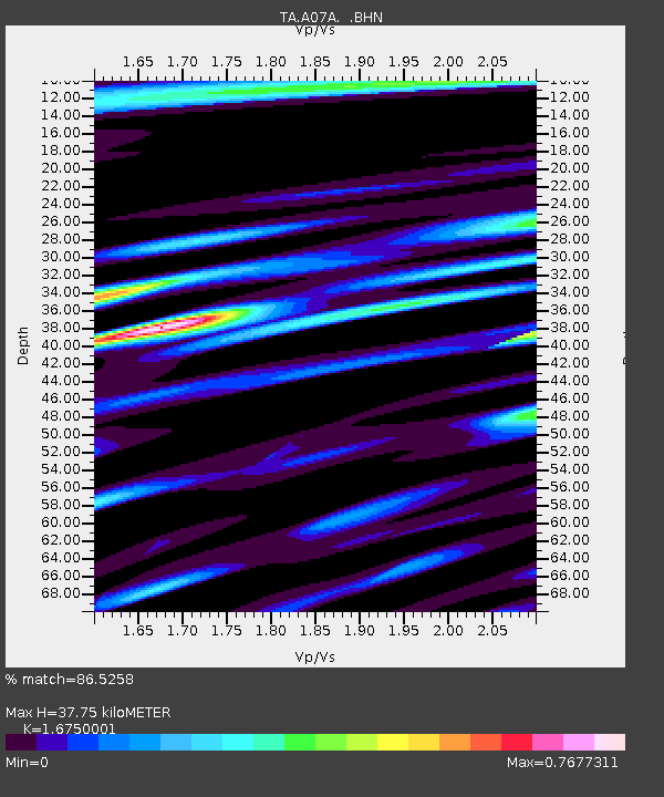
| Estimated Moho Depth: |
37.75 km |
| Estimated Crust Vp/Vs: |
1.68 |
| Assumed Crust Vp: |
6.566 km/s |
| Estimated Crust Vs: |
3.92 km/s |
| Estimated Crust Poisson's Ratio: |
0.22 |
|
| Radial Match: |
86.5258 % |
| Radial Bump: |
400 |
| Transverse Match: |
77.61377 % |
| Transverse Bump: |
400 |
| SOD ConfigId: |
2564 |
| Insert Time: |
2010-03-07 04:01:38.085 +0000 |
| GWidth: |
2.5 |
| Max Bumps: |
400 |
| Tol: |
0.001 |
|
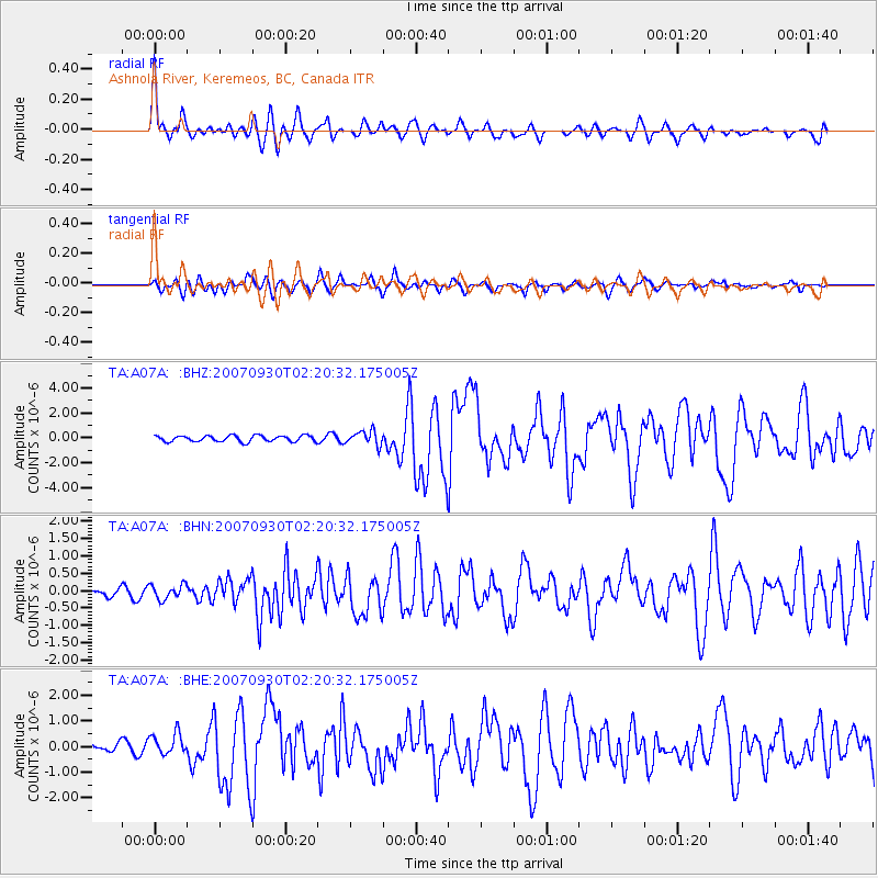
Signal To Noise
| Channel | StoN | STA | LTA |
| TA:A07A: :BHN:20070930T02:20:32.175005Z | 1.1393591 | 2.1460822E-7 | 1.8835873E-7 |
| TA:A07A: :BHE:20070930T02:20:32.175005Z | 2.4321473 | 4.145039E-7 | 1.7042713E-7 |
| TA:A07A: :BHZ:20070930T02:20:32.175005Z | 2.335658 | 5.6666255E-7 | 2.4261362E-7 |
| Arrivals |
| Ps | 4.0 SECOND |
| PpPs | 15 SECOND |
| PsPs/PpSs | 19 SECOND |


