
Station TA A07A - Ashnola River, Keremeos, BC, Canada
Network: TA - USArray Transportable Network (new EarthScope stations)
Nearby stations (2 deg radius)
| Station | Name | (Lat, Lon) | Start / End | Elevation |
| A07A | Ashnola River, Keremeos, BC, Canada | (49.05, -120.38) | 2006-10-14 / 2499-01-01 | 1.8 km |
| Crust2 Type: | L8,thin continental arc, Cordilleras, 0.5 km seds. |
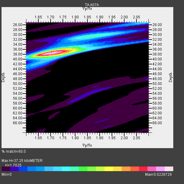
| Thickness Estimate: | 37 km |
| Thickness StdDev: | 1.1 km |
| Vp/Vs Estimate: | 1.70 |
| Vp/Vs StdDev: | 0.04 |
| Vs Estimate: | 3.857 km/s |
| Poisson's Ratio: | 0.24 |
| Peak Value: | 0.02 |
| Assumed Vp: | 6.566 km/s |
| Ps Weight: | 0.33333334 |
| PpPs Weight: | 0.33333334 |
| PsPs Weight: | 0.33333328 |
| Residual Complexity: | 0.437 |
| Nearby stations H: | +- |
| (2.0 deg) Vp/Vs: | +- |
9 with match > 90% ( 31.034483 %) and 29 with match > 80% ( 100.0 %) out of 29.
Download stack as xyz text file.
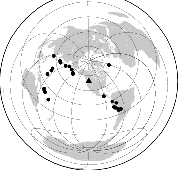
Azimuth Distribution of Events:
Prior Results for this Station
| Study | Thickness | Vp/Vs | Vp | Vs | Poissons Ratio | Extra |
| EARS | 37 km | 1.70 | 6.566 km/s | 3.857 km/s | 0.24 | |
| Crust2.0 | 34 km | 1.77 | 6.566 km/s | 3.707 km/s | 0.27 | L8,thin continental arc, Cordilleras, 0.5 km seds. |
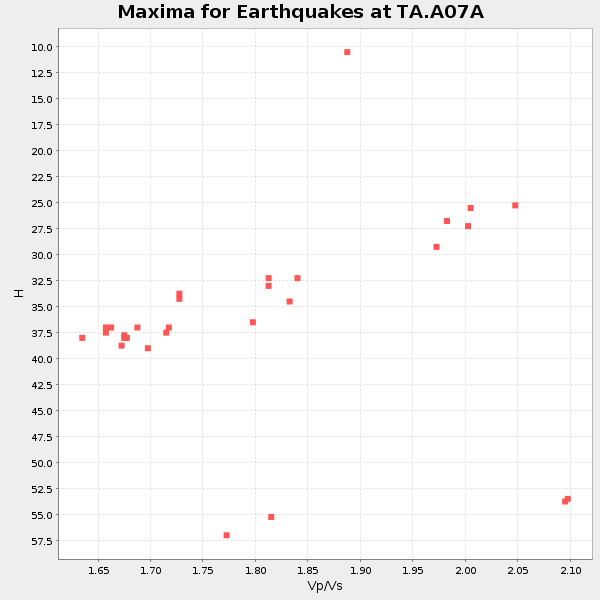
| Global Maxima | 37 km | 1.70 | 6.566 km/s | 3.857 km/s | 0.24 | amp=0.0228729 |
| Local Maxima 1 | 38 km | 1.75 | 6.566 km/s | 3.752 km/s | 0.26 | amp=0.010405409 |
| Local Maxima 2 | 30 km | 1.87 | 6.566 km/s | 3.511 km/s | 0.30 | amp=0.008749394 |
| Local Maxima 3 | 25 km | 2.09 | 6.566 km/s | 3.142 km/s | 0.35 | amp=0.00557694 |
| Local Maxima 4 | 53 km | 1.88 | 6.566 km/s | 3.502 km/s | 0.30 | amp=0.0022163573 |
| Predicted Arrivals for vertical incidence (zero ray parameter) | |
| Ps | 3.99 SECOND |
| PpPs | 15.33 SECOND |
| PsPs/PpSs | 19.32 SECOND |
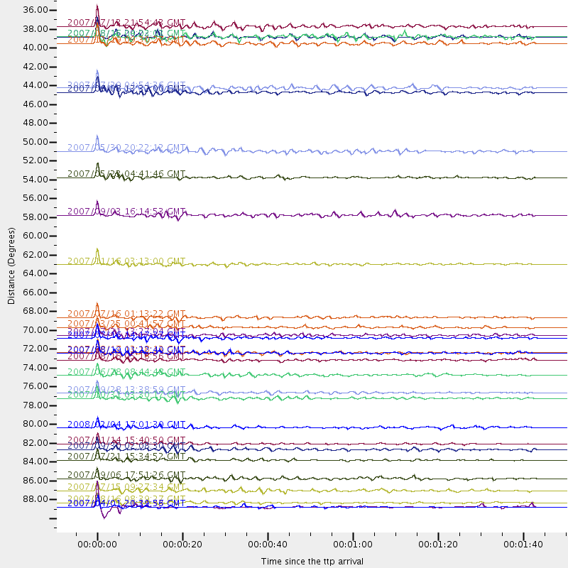
Events Processed for this Station
Download zip of receiver functions as SAC
Plot maxima for each earthquake.
Events Used in the Stack
(29 events)| Radial Match | Distance | Baz | FERegion | Time | Lat/Lon | Depth | Magnitude |
| 97.33495 | 91.5 deg | 258.899 deg | Solomon Islands | 2007/04/01 20:39:56 GMT | (-8.5, 157.0) | 10 km | 6.8 MB, 7.9 MS, 8.1 MW, 7.7 ME |
| 97.25304 | 84.0 deg | 134.051 deg | Northern Chile | 2007/11/14 15:40:50 GMT | (-22.2, -69.9) | 40 km | 6.7 MB, 7.4 MS, 7.7 MW, 7.4 ME |
| 93.77228 | 78.1 deg | 289.701 deg | Volcano Islands, Japan Region | 2007/09/28 13:38:59 GMT | (22.0, 142.7) | 276 km | 6.7 MB, 7.4 MW, 7.4 MW |
| 93.40487 | 36.2 deg | 294.304 deg | Andreanof Islands, Aleutian Is. | 2007/08/15 20:22:11 GMT | (50.3, -177.5) | 9.0 km | 6.3 MB, 6.2 MS, 6.4 MW, 5.9 ML |
| 92.77856 | 73.4 deg | 135.408 deg | Near Coast Of Peru | 2007/08/17 13:18:13 GMT | (-13.6, -76.6) | 48 km | 5.6 MB, 5.6 MS, 5.9 MW |
| 91.9621 | 85.9 deg | 130.742 deg | Jujuy Province, Argentina | 2007/07/21 15:34:52 GMT | (-22.2, -65.8) | 290 km | 5.8 MB, 6.4 MW, 6.3 MW |
| 90.72055 | 89.5 deg | 245.812 deg | Vanuatu Islands | 2007/07/15 09:27:34 GMT | (-15.4, 168.6) | 8.0 km | 6.0 MB, 5.8 MS, 6.1 MW, 6.0 MW |
| 90.55185 | 69.2 deg | 303.445 deg | Near West Coast Of Honshu, Japan | 2007/07/16 01:13:22 GMT | (37.5, 138.4) | 12 km | 6.5 MB, 6.4 MS, 6.6 MW, 6.5 MW |
| 90.423775 | 35.0 deg | 296.308 deg | Andreanof Islands, Aleutian Is. | 2007/07/13 21:54:43 GMT | (51.8, -176.3) | 35 km | 5.7 MB, 5.6 MS, 6.0 MW, 5.9 MW |
| 89.82655 | 91.0 deg | 256.196 deg | Solomon Islands | 2007/08/16 08:39:27 GMT | (-9.8, 159.5) | 10 km | 6.1 MB, 6.7 MS, 6.4 MW |
| 89.661736 | 78.7 deg | 285.66 deg | Mariana Islands | 2007/10/31 03:30:17 GMT | (18.9, 145.4) | 223 km | 6.2 MB, 7.2 MW, 7.2 MW |
| 89.0028 | 73.4 deg | 135.433 deg | Near Coast Of Peru | 2007/08/19 01:22:40 GMT | (-13.6, -76.6) | 26 km | 5.9 MB, 5.4 MS, 5.8 MW, 5.5 ML |
| 88.69968 | 63.0 deg | 130.68 deg | Peru-Ecuador Border Region | 2007/11/16 03:13:00 GMT | (-2.3, -77.8) | 123 km | 6.3 MB, 6.8 MW, 6.7 MW |
| 88.59164 | 71.7 deg | 305.155 deg | Sea Of Japan | 2007/07/16 14:17:37 GMT | (36.8, 134.9) | 350 km | 6.2 MB, 6.8 MW, 6.8 MW |
| 88.4913 | 37.0 deg | 296.676 deg | Andreanof Islands, Aleutian Is. | 2007/12/19 09:30:27 GMT | (51.4, -179.5) | 29 km | 6.4 MB, 7.1 MS, 7.1 MW, 7.0 MW |
| 87.0919 | 42.3 deg | 303.817 deg | Komandorskiye Ostrova Region | 2007/07/29 04:54:36 GMT | (53.6, 169.7) | 26 km | 6.0 MB, 5.5 MS, 5.9 MW, 5.8 MW |
| 86.5258 | 84.7 deg | 279.769 deg | South Of Mariana Islands | 2007/09/30 02:08:30 GMT | (10.5, 145.7) | 14 km | 6.4 MB, 7.1 MS, 6.9 MW, 6.9 MW |
| 86.411644 | 49.7 deg | 306.749 deg | Kamchatka Peninsula, Russia | 2007/05/30 20:22:12 GMT | (52.1, 157.3) | 116 km | 6.4 MB, 6.4 MW, 6.4 MW |
| 86.333176 | 82.2 deg | 133.104 deg | Near Coast Of Northern Chile | 2008/02/04 17:01:30 GMT | (-20.2, -70.0) | 44 km | 6.0 MB, 6.2 MS, 6.3 MW, 6.3 MW |
| 85.75591 | 70.3 deg | 304.447 deg | Near West Coast Of Honshu, Japan | 2007/03/25 00:41:57 GMT | (37.3, 136.6) | 8.0 km | 6.1 MB, 6.8 MS, 6.7 MW, 6.6 MW |
| 85.002754 | 76.0 deg | 134.93 deg | Near Coast Of Peru | 2007/06/28 08:44:48 GMT | (-15.7, -74.9) | 27 km | 5.5 MB, 5.3 MS, 5.8 MW, 5.8 MW |
| 84.86159 | 52.8 deg | 50.354 deg | Northern Mid-Atlantic Ridge | 2007/05/23 04:41:46 GMT | (52.4, -31.8) | 10 km | 5.6 MS, 5.4 MB, 5.7 MW, 5.6 MW |
| 84.80169 | 74.2 deg | 135.321 deg | Near Coast Of Peru | 2007/08/16 05:16:56 GMT | (-14.3, -76.1) | 23 km | 5.8 MB, 6.1 MS, 6.3 MW, 6.2 ML |
| 84.32581 | 91.5 deg | 260.626 deg | Solomon Islands | 2007/04/01 21:11:33 GMT | (-7.3, 155.7) | 10 km | 6.3 MB |
| 83.175186 | 36.3 deg | 294.187 deg | Andreanof Islands, Aleutian Is. | 2007/08/16 04:03:03 GMT | (50.2, -177.6) | 15 km | 5.8 MB |
| 82.952484 | 88.1 deg | 305.878 deg | Taiwan Region | 2007/09/06 17:51:26 GMT | (24.3, 122.2) | 53 km | 6.1 MB, 6.2 MW, 6.1 ME |
| 82.1172 | 42.7 deg | 134.972 deg | Near Coast Of Guatemala | 2007/06/08 13:32:00 GMT | (13.8, -90.8) | 48 km | 5.5 MB, 5.4 MS, 5.8 MW, 5.8 MW |
| 81.96971 | 57.2 deg | 303.706 deg | Kuril Islands | 2007/09/03 16:14:53 GMT | (45.8, 150.1) | 94 km | 6.3 MB, 6.2 MW, 6.2 ME |
| 81.786575 | 71.3 deg | 127.797 deg | Western Brazil | 2007/07/21 13:27:04 GMT | (-8.1, -71.3) | 645 km | 6.2 MB, 6.1 MW, 6.0 MW |
Losers
(0 events)| Radial Match | Distance | Baz | FERegion | Time | Lat/Lon | Depth | Magnitude | Reason |
