You are here: Home > Network List > TA - USArray Transportable Network (new EarthScope stations) Stations List
> Station A07A Ashnola River, Keremeos, BC, Canada > Earthquake Result Viewer
A07A Ashnola River, Keremeos, BC, Canada - Earthquake Result Viewer
| Earthquake location: |
Near Coast Of Peru |
| Earthquake latitude/longitude: |
-13.6/-76.6 |
| Earthquake time(UTC): |
2007/08/19 (231) 01:22:40 GMT |
| Earthquake Depth: |
26 km |
| Earthquake Magnitude: |
5.9 MB, 5.4 MS, 5.8 MW, 5.5 ML |
| Earthquake Catalog/Contributor: |
WHDF/NEIC |
|
| Network: |
TA USArray Transportable Network (new EarthScope stations) |
| Station: |
A07A Ashnola River, Keremeos, BC, Canada |
| Lat/Lon: |
49.05 N/120.38 W |
| Elevation: |
1842 m |
|
| Distance: |
73.4 deg |
| Az: |
331.647 deg |
| Baz: |
135.433 deg |
| Ray Param: |
0.052993283 |
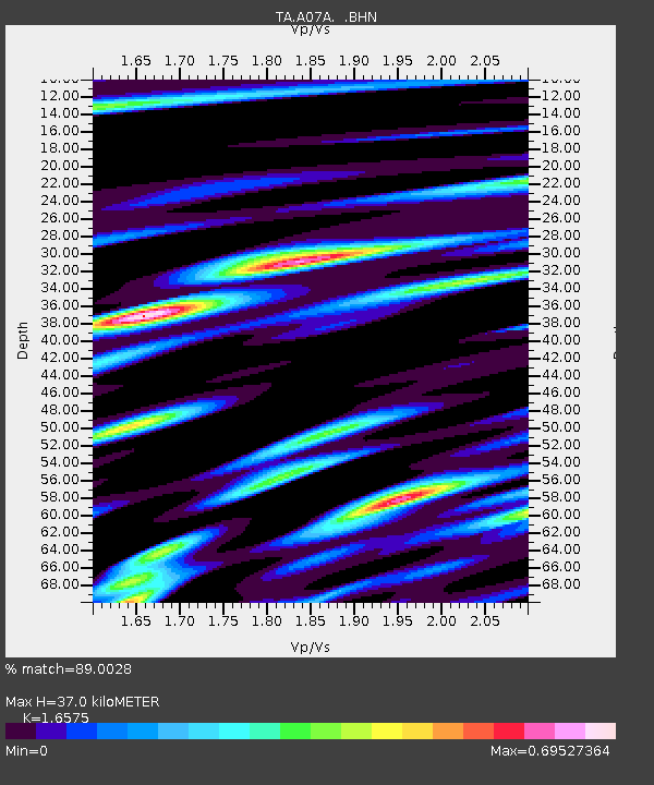
| Estimated Moho Depth: |
37.0 km |
| Estimated Crust Vp/Vs: |
1.66 |
| Assumed Crust Vp: |
6.566 km/s |
| Estimated Crust Vs: |
3.961 km/s |
| Estimated Crust Poisson's Ratio: |
0.21 |
|
| Radial Match: |
89.0028 % |
| Radial Bump: |
379 |
| Transverse Match: |
86.11822 % |
| Transverse Bump: |
395 |
| SOD ConfigId: |
2564 |
| Insert Time: |
2010-03-07 04:01:43.758 +0000 |
| GWidth: |
2.5 |
| Max Bumps: |
400 |
| Tol: |
0.001 |
|
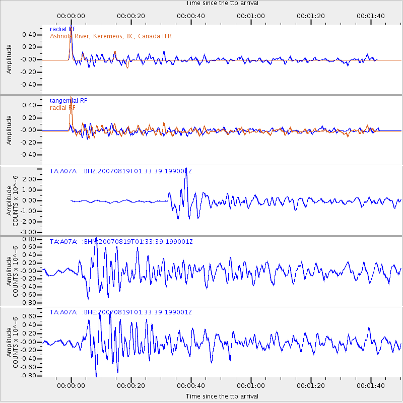
Signal To Noise
| Channel | StoN | STA | LTA |
| TA:A07A: :BHN:20070819T01:33:39.199001Z | 1.8961571 | 1.1403274E-7 | 6.013886E-8 |
| TA:A07A: :BHE:20070819T01:33:39.199001Z | 2.7736406 | 8.137547E-8 | 2.9338864E-8 |
| TA:A07A: :BHZ:20070819T01:33:39.199001Z | 5.5818653 | 3.8111222E-7 | 6.8276854E-8 |
| Arrivals |
| Ps | 3.8 SECOND |
| PpPs | 14 SECOND |
| PsPs/PpSs | 18 SECOND |


